Rain received across central Plains and Midwest
The active Atlantic hurricane season continued (with respect to number of named storms) as minimal Tropical Storm Fay formed off the Carolina coast, moved northward, and made landfall in New Jersey. Rainfall from Fay was beneficial for parts of the Northeast.
Elsewhere, a series of slow-moving fronts drifted across the lower 48 states, generating MCCs (Mesoscale Convective Complexes) with swaths of decent rain across parts of the central Plains, Midwest, and Southeast. Several fronts produced scattered but heavy thunderstorms across the upper Midwest.
Unfortunately, many areas received little or no precipitation this week, including much of the West (from the Rockies to the Pacific Coast), the southern Plains, lower and middle Mississippi River Valleys, and most of the Appalachians and Piedmont. Unfortunately, the dryness was accompanied by excessive heat (weekly temperatures averaged more than 4 degrees F above normal) in the southwestern and northeastern quarters of the Nation. For example, Borger, Texas, set an all-time record high of 116 degrees F on July 11.
The combination of heat and minimal rainfall was a concern for many agricultural areas as crops are at critical stages of growth and reproduction, and with high evapotranspiration rates during the summer heat, topsoil moisture can become rapidly depleted and stress the crops. In contrast, the Northwest recorded subnormal temperatures (2 to 6 degrees F below normal), along with some light precipitation in northernmost regions.
South
Similar to the Southeast, decent rainfall was generally lacking except for a few areas. Unexpected moderate to heavy (1 to 3 inches, locally to 6 inches) rains from a couple of MCCs fell on the south-central Great Plains (central Kansas and eastern half of Oklahoma), providing some relief from drying conditions. Tulsa, Oklahoma, measured only 0.11” of rain in June, but has 4.00” the first 13 days of July. The rains also ended excessive heat over the weekend when Borger, Texas, set its all-time highest reading at 116 degrees F on July 11, and numerous Oklahoma sites exceeded 115 degrees F for their heat index (two sites hit 120 degrees F).
In contrast, little or no rain combined with excessive heat (weekly temperatures averaging 4-10 degrees F above normal) exacerbated conditions in southwestern Texas, the Texas and Oklahoma Panhandles, and much of New Mexico. South Texas remained wet at 60-days and beyond, but continued lack of rain and heat should soon start taking a toll on the soil moisture and agriculture.
Midwest
Just like the Southeast and South regions, the Midwest also saw areas with heavy rains, and others with nothing. Unfortunately, a big concern was short-term (30-days) dryness combined with above-normal temperatures and evapotranspiration (creating high weekly EDDI values) during the critical time for crop growth and pollination. In addition, some states have vulnerable soil characteristics (e.g. sandy, high clay, or shallow rocky) to flash drought situations. With respect to rainfall, light to moderate totals (1-3 inches, locally to 6 inches) fell on portions of the upper Midwest (Minnesota and Wisconsin), and parts of the Ohio Valley (east-central Illinois, southwest Indiana, western Kentucky, eastern Ohio) where improvements were made if totals were significant (>2 inches).
However, little or no rain was measured in the southern half of Iowa, much of Missouri, western Illinois, and scattered locations in eastern Kentucky, central Indiana, central Ohio, and northern lower Michigan. Accordingly, D0 was expanded in parts of Ohio, Michigan, Missouri, and Iowa, with D1 developing in portions of Ohio, Indiana, and Illinois, and expanding in western Iowa. USDA/NASS crop conditions as of July 12 rated poor or very poor have reached or surpassed 10% for corn in Indiana and Ohio, and soy in Illinois, Indiana, and Ohio. Although some light scattered showers fell on lower Michigan and there is a wet signal at 60-days and beyond, recent excessive heat produced very high ET rates (and high QuickDri and EDDI values). This heat impacted Michigan’s corn and soybeans, with July 12 crop conditions rated poor or very poor at 17% and 13%, respectively, with pastures similarly rated at 28%.
High Plains
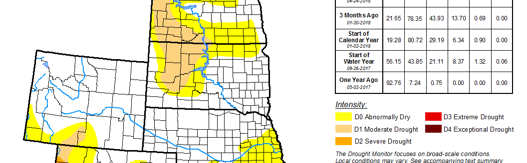
Northern and western states had seen an improvement trend the past several weeks as wetter and cooler conditions have gradually eased drought and dryness from Montana and the Dakotas. However, southern states have seen a gradual deterioration this summer, with some or most of Wyoming, Colorado, Nebraska, and Kansas in drought (D1 or drier).
Fortunately, several MCCs formed in the north-central and central Plains this week, bringing welcome rainfall (1 to 3 inches, locally 5 inches) to southern South Dakota, central Nebraska, and central Kansas. As a result, some D0 was removed from northern and eastern Montana, southwestern South Dakota, and parts of central Nebraska and Kansas. D1 was improved to D0 in northern and western North Dakota, southwestern South Dakota, northeastern Nebraska (but expanded into eastern Nebraska and western Iowa), and southeastern Kansas. Lighter amounts (an inch or less) also fell on northern and eastern Montana, most of the Dakotas and Nebraska, northeastern Colorado, and most of Kansas. However, high heat negated the effects of the rain in the southern and central High Plains, causing expansion of D0 and drought (D1-D3) in much of Colorado, southern Wyoming, western Nebraska, and western Kansas.
West
Dry weather prevailed across much of the West, with the southwest monsoon yet to arrive in the Southwest. While temperatures averaged near or below normal in the northern half of the region, above to much above normal readings baked parts of the Southwest, southern Rockies, and southern High Plains. With the late start to the summer monsoon and oppressive heat, deteriorations were made in New Mexico, Colorado, southern Nevada, southwest Utah, parts of central coastal California, and portions of Oregon. In New Mexico, the combination of extreme heat stress and high ET on what rain that had fallen over the past few weeks included coverage of D0 in southwestern sections, D1 expansion in central and southeastern portions, and some D3 increase in the northwest, northeast, and southeast.