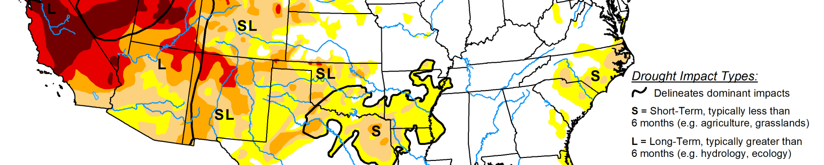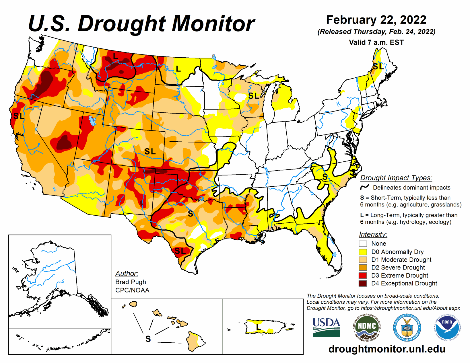
A low pressure system developed across the southern Great Plains by Feb. 17 and rapidly tracked northeastward to the Ohio Valley and Northeast a day later. To the northwest of the surface low track, snowfall amounts exceeded 6 inches across northeast Kansas, northern Missouri, and north-central Illinois. In the warm sector of this storm system, severe thunderstorms with locally heavy rainfall (more than 1 inch) affected the Tennessee Valley and parts of the Lower Mississippi Valley.
Another low pressure system developed by Feb. 21 with a similar northeastward track to the Ohio Valley. 7-day precipitation amounts, from Feb. 15 to 21, exceeded 2 inches across much of the Ohio and Tennessee Valleys, Ozarks region, southeast Oklahoma, and parts of northern Texas. Farther to the south and west, little to no rainfall occurred closer to the Gulf Coast along with the Rio Grande Valley and central to southern high Plains. This precipitation pattern during mid-February and the primary storm track across the Ohio Valley are typical during La Nina. Although there was accumulating snow across the northern to central Rockies and northern Cascades this past week, the drier-than-normal pattern persisted throughout most of the West. 7-day temperatures, for the week ending on Feb. 22, averaged above normal across the East, lower Mississippi Valley, and western Gulf Coast.
South
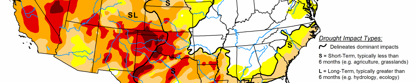
A sharp gradient in precipitation was observed from north to south across this region which is typical for La Nina during mid-February. Seven-day precipitation amounts, from Feb. 15 to 21, exceeded 2 inches across most of the northern half of Mississippi, northern two-thirds of Arkansas, southeastern Oklahoma, and northwestern Texas. A 1-category improvement was made to these areas that received the heavier rainfall. Conversely, farther to the south, a 1-category degradation was made to parts of the lower Mississippi Valley, western Gulf Coast, and central to southern Texas where little to no rainfall occurred this past week.
Although no changes were made this week to the southern high Plains, soil moisture continues to rank in the lowest 5th percentile consistent with much of this region being designated with D3 levels of drought. The lack of adequate soil moisture remains a major concern for the winter wheat crop across the southern Great Plains, while many counties of Oklahoma and Texas remain under a burn ban.
Midwest
A swath of moderate to heavy snow with 7-day liquid equivalent amounts of more than 1 inch resulted in a slight reduction in the abnormal dryness (D0) and moderate drought (D1) across north-central Illinois and southeast Iowa. A decrease in the D0 coverage was also made to parts of Missouri where recent rainfall has led to improving conditions including a favorable response in 28-day average streamflows. However, most ongoing D0 and D1+ areas of the Midwest Region received less than 0.5 inch, liquid equivalent, which supported going with status quo this week. Farther to the north, a deepening snowpack with snow water equivalent of 2.5 to 4 inches supported a 1-category improvement to much of northern Minnesota.
High Plains
Following two weeks of worsening conditions across the central Great Plains, additional degradations were made to parts of Kansas and southern Nebraska. These degradations were supported by 30- to 120-day SPI and soil moisture indicators. Snowfall of more than 6 inches during mid-February and favorable snow water equivalent values supported a one category improvement over the Bitterroots of western Montana. A small reduction in exceptional drought (D4) and extreme drought (D3) was made to western and south-central Montana, due to this past week’s snowfall (more than 0.5 inch, liquid equivalent) along with consideration of SWE for the season and long-term SPIs.
West
Following the wet December 2021 for much of the West, a dry pattern persisted since early January. 2022 year-to-date precipitation averages less than 25 percent of normal throughout much of California and the Great Basin. Snow water equivalent (SWE) continues to decline due to the dry pattern during January and February with SWE falling below 75 percent of normal for much of the southern Cascades, Sierra Nevada Mountains, and Great Basin. Due to the persistently dry pattern since early January, a 1-category degradation was made to parts of northern California and southwest Oregon which reflects the extreme (D3) levels of drought according to the 24-month and 2022 year-to-date SPI, soil moisture indicators, and 28-day average streamflows. Without a major pattern change during March, additional degradations may be needed for California and the Great Basin in the weeks ahead.
A slight expansion of D3 was made to northern Wyoming to be consistent with 12 to 24-month SPIs. Recent snowfall with SWE currently running near to above average prompted a 1-category improvement to the north of Denver, Colorado. Based on a favorable snowpack across the Clearwater and Salmon basins of central Idaho, severe (D2) was improved to moderate (D1) drought for that part of Idaho. Moderate drought (D1) was degraded to severe drought (D2) across the Upper Snake River basin of Idaho as SWE for the headwaters or this basin are nearing the 10th percentile. 7-day precipitation amounts of more than 1 inch, liquid equivalent, prompted a 1-category improvement from extreme (D3) to severe (D2) drought across parts of south-central Montana. Periods of above-normal temperatures coupled with enhanced surface winds support an expansion of severe (D2) to extreme (D3) drought across southern and eastern New Mexico. These worsening conditions are also consistent with SPEI at various time scales and the depiction for western Texas.