A strong low pressure system resulted in widespread precipitation (0.5 to 3 inches, liquid equivalent) from the central Rockies east to the northern and central Great Plains from Oct. 11 to 13. More than a foot of snow blanketed parts of Montana, Wyoming, and western South Dakota. Along a trailing cold front, heavy to excessive rainfall (1 to 3 inches, locally more) occurred across eastern Oklahoma and central to eastern Texas.
As this front progressed eastward, scattered thunderstorms with locally more than one inch of rainfall swept across the Ohio and Tennessee Valleys. Much of New York and northern New England received 1 to 2.5 inches of rainfall on October 16. Only light weekly precipitation amounts (generally less than 1 inch, liquid equivalent) were observed along the Cascades, coastal ranges of the Pacific Northwest, and northern Sierra Nevada Mountains from Oct. 12 to 18. Dry weather prevailed throughout much of the Southeast, Southwest, and northern Intermountain West during this 7-day time period. Southeastern Mainland Alaska and the Alaska Panhandle received near normal precipitation amounts during mid-October. Enhanced trade winds resulted in locally heavy rain across east-facing slopes of the Big Island of Hawaii recently. Locally heavy rainfall also occurred throughout Puerto Rico this past week. 7-day temperatures (Oct 12-18) remained above average across the eastern third of the U.S., while below average temperatures were observed over the West.
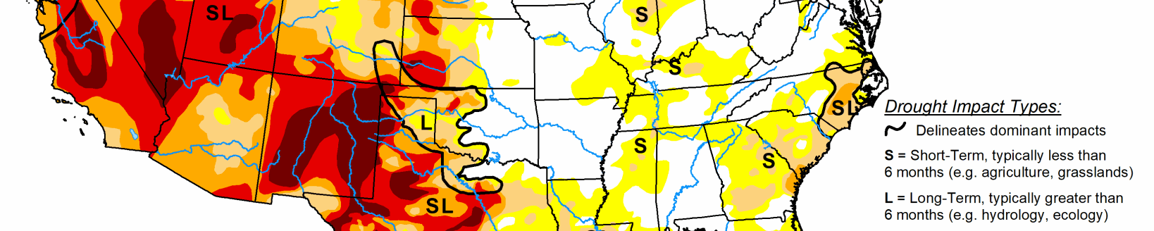
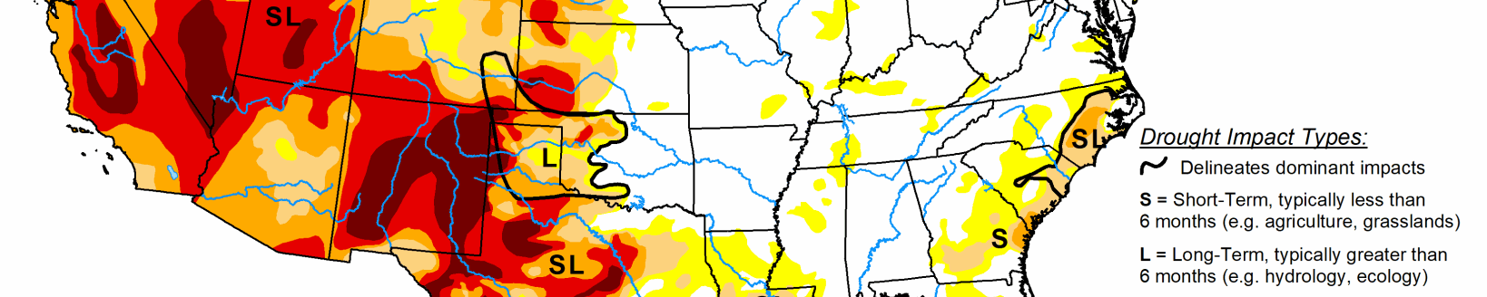
South
Following rapid expansion of D0 (abnormal dryness) and D1 (short-term moderate drought) during September across Oklahoma and northwest Arkansas, above normal precipitation during the first half of October resulted in a continued decrease in the coverage of D0 and D1. Month-to-date rainfall amounts totaled 2 to 6 inches throughout much of central and eastern Oklahoma along with northwest Arkansas. Farther south into central Texas, recent heavy rainfall also supported minor modification to the ongoing D0 and D1 areas. Abnormal dryness (D0) was maintained for parts of southeast Oklahoma due to ongoing 30 to 60-day indicators and lower rainfall amounts during the past two weeks. Abnormal dryness (D0) and short-term moderate drought (D1) was expanded slightly to include more of southwest Arkansas and northwest Louisiana which missed out on the heavier rainfall this past week and precipitation deficits have increased. Moderate (D1) to severe (D2) drought continues to expand across west Texas where 60-day precipitation deficits range from 2 to 5 inches and soil moisture indicators have worsened.
Midwest
Recent rainfall and improving stream flows resulted in a 1-category improvement to parts of western and northern Minnesota, while insufficient precipitation during the past 30 days prompted an expansion of abnormal dryness (D0) from southeast Minnesota into parts of Wisconsin. Rainfall during mid-October resulted in a slight decrease in the southern extent of D0 and D1 areas of northern Illinois. Also, the spatial extent of D0 was decreased in Missouri based on 30-day precipitation and improving streamflows. SPIs at various time scales, 28-day average streamflows, and soil moisture remain near or above normal throughout the eastern Corn Belt and Ohio Valley.
High Plains
Widespread precipitation (1 to 3 inches, liquid equivalent) since 12Z on Oct 12 prompted a large 1-category improvement across the Dakotas and an adjustment to only show long-term drought impacts for much of the northern Plains. Excluding the northwest corner of North Dakota, 14-day precipitation amounts have totaled 2 to 6 inches. Extreme drought (D3) remains across northwest North Dakota, based on long-term SPIs and soil moisture below the 5th percentile. Improvements were also made across parts of Nebraska and Kansas due to weekly precipitation amounts of greater than 1 inch and soil moisture recovery. Likewise, an increase in soil moisture indicators resulted in small improvements across parts of Wyoming.
West
Severe (D2) to exceptional (D4) drought continues throughout much of the Pacific Northwest, California, and the Great Basin. Nearly all of this region remained status-quo in terms of drought changes as the Monsoon season ended and the wet season just began. A robust Monsoon brought an end to short-term drought impacts across Arizona and southern Utah, but long-term drought impacts persist. Along and west of the Cascades, above normal precipitation was observed across western Oregon and Washington since mid-September. This favorable start to the wet season along with improving streamflows and SPI values support the removal of small D4 in Douglas and Linn counties of Oregon. Periods of beneficial precipitation and cooler temperatures led to an improvement from D4 to D3 along the mountain range front in Utah. However, D4 persists across the Sevier River Basin of southern Utah. The increase in precipitation, related to the onset of the wet season, along with much cooler temperatures resulted in a large decrease in the number of large wildfires throughout the West during mid-October. Extreme drought (D3) was expanded across northwest Montana based on 28-day streamflows near the 5th percentile along with 30 to 60-day SPIs. Conversely, last week’s major storm prompted slight reduction in drought intensity across parts of eastern Montana.