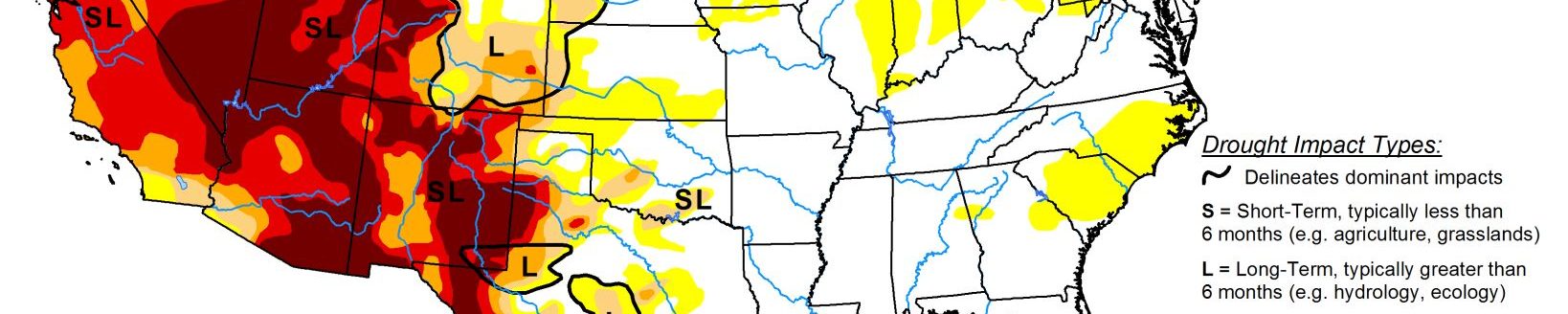
Drought intensifying quickly in southern High Plains; Midwest remains free of drought
Light precipitation at best covered most of the 48 states, so drought deterioration was more common than improvement this past week. Less than half an inch fell on most areas across the Southeast, Great Lakes Region, central and northern Plains, Mississippi Valley, Texas, and from the Rockies to the Pacific Coast. Widespread light to moderate precipitation covered the Northeast and the central Appalachians, and a fairly broad area centered along the Ohio Valley received from a few tenths to one-half inch.
Farther west, there were a few exceptions to the generally dry week. More than 2 inches of rain soaked parts of the south-central Great Plains and adjacent western Mississippi Valley, western Deep South Texas, and central Montana. The broadest area of heavy precipitation covered a solid swath from south-central Kansas through southern Missouri, where totals ranged from 2 to nearly 4 inches.
Similar amounts were more scattered in a stripe from southern Oklahoma and northeastern Texas through southern Louisiana, as well as in central Montana. Isolated sites in southwestern Texas were soaked by as much as 6 inches of rain, but closer to 2 inches fell on most locales there. Elsewhere, there were a few areas of moderate to precipitation from the northern High Plains into central Montana, and in orographically favored parts of the northern Cascades.
High Plains
Drought is intensifying quickly across the southern tier of this region from southern Colorado through western Kansas. Severe D2 drought is now extant throughout this area, and extreme D3 drought envelops much of southern Colorado and adjacent southwestern Kansas. Most of this region has recorded less than an inch of precipitation during the past 3 months, and at best a few tenths of an inch have fallen mid-March. Abnormally warm weather is exacerbating the acute dryness.
The past 3 months have averaged 2 to 4 degrees F above normal, and since late April, averages have been 7 to 9 degrees F above normal. Farther north and east, many areas fell into abnormal dryness this past week as precipitation deficits continued to slowly accumulate. Many areas have seen precipitation totals among the driest 5% of historical occurrences for the last 30 days, or 90 days, or both.
D0 was introduced where the dryness has been most acute for 1 to 3 months, specifically southeastern Nebraska, a swath from southwest to north-central Iowa, part of eastern South Dakota, southeastern Minnesota, and a large area across central and northern Minnesota. Precipitation has been sharply below normal for at least a few weeks, but impacts have been limited so far. Water supplies, agriculture, and soil moisture have been minimally affected, so the assessment is less intense than most precipitation statistics would imply. At some point, conditions could deteriorate rapidly if these trends continue, so this region must be monitored closely as we move into the growing season.
Farther west, northwest South Dakota and surrounds was one of very few areas to improve this past week, along with part of north-central North Dakota. Generally 2 to 4 inches of precipitations moistened up these regions in the last 2 weeks, eliminating D0 in northwestern South Dakota and adjacent areas.
Precipitation has not been as generous across northern Wyoming, with D0 stretching into northeastern parts of the state, and adjacent Montana. Precipitation among the driest 10% on record was observed in the new D0 areas over the last 4 months. On the other end of the state, abnormal dryness was also introduced in southwestern Wyoming adjacent to Utah.
South
Surplus rainfall has prevailed across the interior, but dryness and drought are entrenched along most of the Gulf Coast, and across southern Texas. Less extreme dryness covers part of central Texas, western Oklahoma and adjacent Texas, and the lower Big Bend. D0 prevails across these regions, with only scattered patches of moderate drought. In contrast, extreme D3 drought has developed in a few regions across southern Texas, primarily near the Gulf of Mexico and along the Rio Grande, while severe drought is impacting a large part of southeastern Texas and smaller areas near the Mexican Border. A small area of intense rainfall – up to 5 inches in spots – brought relief to western Deep South Texas, with the wettest areas improving from severe D2 drought to abnormal dryness (D0). Areas of severe to extreme drought recorded less than half of normal rainfall for the past 90 days, with rainfall deficits of 5 to 7 inches observed southeast of Victoria.
Midwest
This region remains free of drought, with persistently above-normal precipitation prevailing for over a year in some areas. Still, a few small areas of abnormal dryness have developed. One in east-central Michigan grew slightly this past week, and a small area of D0 pushed into west-central Wisconsin from the broader-scale dryness farther west.