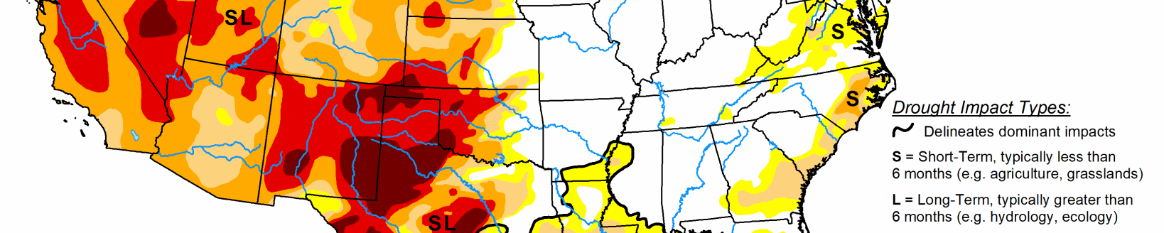
Parts of South Dakota, Nebraska and Kansas see widespread improvements after heavy rains

This U.S. Drought Monitor week was marked by ongoing active weather across areas of the conterminous U.S. including the Pacific Northwest, Northern Rockies, Plains, Lower Midwest, and isolated areas of the South and Southeast. The most severe weather was observed across the Central Plains and areas of the Midwest where numerous tornadoes touched down in areas including eastern Kansas, southeastern Nebraska, and northern Illinois.
Widespread heavy rainfall accumulations were also observed, ranging from 2 to 7 inches, with the heaviest accumulations in eastern Nebraska. The rainfall events provided much-needed moisture to the region, boosting soil moisture levels across parched areas from Kansas to South Dakota.
The windy, dry conditions exacerbated fire-weather conditions in Arizona and New Mexico where several large early-season wildfires are currently impacting the region. In northern New Mexico, the Hermits Peak Fire, situated east of Santa Fe in the Sangre de Cristo Mountains, has burned 147,909 acres and is only 20% contained (May 4), according to the National Interagency Coordination Center.
In terms of this week’s map, short-term precipitation led to targeted improvements in the Pacific Northwest, Central Plains, South, and the Southeast, while degradations were registered in the Southwest, Texas, Southeast, and the Mid-Atlantic.
South
In the South, conditions on the map were a mixed bag of improvements and degradations. In southern Louisiana, isolated areas of light-to-moderate rainfall (2 to 4 inches) improved areas of Moderate Drought (D1), Severe Drought (D2), and Extreme Drought (D3) as well as eliminated pockets of Moderate Drought (D1) in northern Louisiana and southern Arkansas.
In areas of Texas (Panhandle, north-central, west-central, Trans-Pecos), isolated bands of heavy rainfall (2 to 4 inches) helped to improve drought-affected areas. Conversely, the combination of above-normal temperatures, dry soils, and increased evaporative demand led to degradation in areas of the Panhandle, southeastern Texas, and the Trans-Pecos.
In the Panhandle of Oklahoma, small areas of Exceptional Drought (D4) expanded in response to short-term rainfall deficits. Reports in this area include very poor rangeland conditions and local ranchers having to rely on supplemental feed for cattle. According to the latest USDA Oklahoma Crop Progress and Conditions report (May 2), wheat crop conditions were rated 51% poor to very poor and soil moisture was 63% short to very short. For the week, average temperatures were mostly above normal (2 to 8+ deg F) with the greatest positive anomalies observed across Texas and western Oklahoma.
Midwest
On this week’s map, minor changes were made including reduction in areas of Abnormally Dry (D0) in Minnesota in response to storm activity which brought 2 to 3 inches of rain to isolated areas of southern Minnesota. Overall, the region has been drought-free with exception of a few dry pockets in western Iowa. Precipitation was generally restricted to the western half of the region with some heavy accumulations (2 to 5 inches) observed in association with severe storms that impacted the Central Plains and areas of the Midwest including Missouri, Iowa, southern Minnesota, and northern Illinois. Average temperatures were below normal (2 to 10+ deg F) across the region, with the largest departures observed in the Upper Midwest. Midwest stream flows (7-day average) were running at normal to above-normal levels with extremely high flows observed in northern Minnesota, according to the USGS.
High Plains
On this week’s map, widespread improvements were made in South Dakota, Nebraska, and Kansas in response to significant rainfall accumulations that helped to improve soil moisture levels and boosted streamflow levels. Rainfall totals for the week ranged from 2 to 8+ inches with the highest totals observed in central South Dakota, eastern and central Nebraska, and northern Kansas.
However, some drought-stricken areas of the region, including extreme southeastern South Dakota, northeastern Nebraska, and central Kansas, largely missed out on this week’s storms. In the eastern plains of Montana, improving conditions (precipitation, soil moisture) led to reduction in areas of Severe Drought (D2) and Extreme Drought (D3). However, it should be noted that recent improvements in eastern Montana are not uniform and many areas are still coping with the impacts (agricultural) of the longer-term drought situation. Average temperatures were below normal across the northern half of the region, with negative departures ranging from 2 to 10+ deg F below normal and the greatest departures observed in eastern portions of the Dakotas. In the southern half of the region, average temperatures were 2 to 8 deg F above normal.
West
Out West, several storm systems moved through the norther tier of the region bringing light to moderate snowfall accumulations to the higher elevations of the Cascades, northern Great Basin, and the Central and Northern Rockies as well as light rainfall to coastal areas and low-lying inland valleys of Idaho, Oregon, and Washington.
Improving conditions in northern Wyoming led to removal of areas of Extreme Drought (D3) in the Big Horn Mountains where current SWE is 108% of median. Elsewhere, conditions deteriorated on the map in northwestern Arizona and across much of New Mexico. Looking at snowpack data across the West at a regional scale (2-digit HUC), the NRCS SNOTEL network (May 3) reported the following median SWE levels: Pacific Northwest 111%, Missouri 99%, Souris-Red-Rainy 116%, California 60%, Great Basin 62%, Upper Colorado 76%, Arkansas-White-Red 50%, Lower Colorado 36%, and Rio Grande 33%. According to NRCS National Water and Climate Center’s reservoir summary report (April 1), statewide reservoir storage levels were below normal in all western states with exception of Washington state.
In California, the state’s two largest reservoirs are at critically low levels moving into the dry season with Shasta Lake currently at 40% of total capacity on May 3 and Lake Oroville at 55% of capacity. In Southern California, the Metropolitan Water District of Southern California announced (April 27) that one-third of its users will be subject to restrictions that limit outdoor watering to one day per week as a measure to reduce water usage. In the Colorado River Basin, Lake Powell was at 24% of capacity and Lake Mead 31% of capacity on May 3, according to the USBR. In the Rio Grande Basin, New Mexico’s Elephant Butte Reservoir was 13% full.