Rains widespread across Kansas and parts of Nebraska
High pressure dominated the southern half of the contiguous U.S. during this U.S. Drought Monitor week. Upper-level weather systems tracked across the U.S.-Canadian border, dragging surface lows and fronts along with them. The frontal systems tapped Gulf of Mexico moisture to drop locally heavy rain across parts of the Plains to Midwest, while convective thunderstorms peppered coastal areas of the Gulf.
The high-pressure ridge inhibited precipitation across much of the southern Plains to Southeast, and across most of the West. It also kept temperatures unusually hot, with daily maximums exceeding 90 degrees F across the South throughout the week and across much of the West for most of the week. The excessive heat spread into the northern Plains, Midwest, and into the Northeast as the week wore on. The persistent heat increased evapotranspiration, which dried soils and stressed crops and other vegetation. The locally heavy rains brought temporary relief from the heat and dryness, but only for those areas in the Plains and Midwest lucky enough to receive the rain.
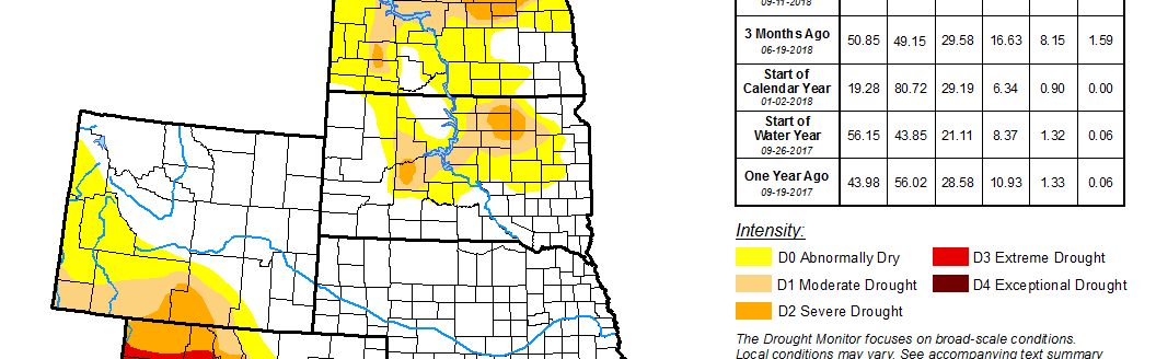
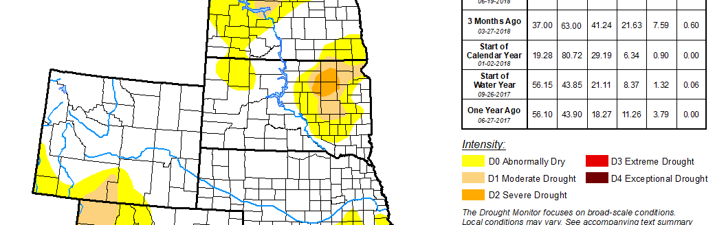
High Plains
Areas of 2+ inches of rain were widespread across Kansas, eastern North Dakota, and parts of Nebraska, with locally over 5 inches in northeast Kansas and southeast Nebraska. But the spigot remained off across most of Wyoming and western and northern parts of Colorado. Drought contracted where the beneficial rains fell, including southeast Colorado, western Kansas to parts of Nebraska, northeast Wyoming, and parts of North Dakota. But drought and abnormal dryness expanded where it continued dry, including eastern Kansas, northeastern Colorado to adjoining parts of Nebraska, northeastern Nebraska, parts of the Dakotas, and especially in Wyoming. Moderate to severe drought expanded in, and extreme drought was added to, Wyoming.
South
Two to locally over 5 inches of rain fell across parts of the Texas panhandle and northwest Oklahoma, and along parts of the Texas to Mississippi coast. But it was another dry week across much of Texas to eastern Oklahoma to northern Mississippi and Tennessee. Moderate to extreme drought contracted in the wet panhandles of Texas and Oklahoma, but moderate to severe drought expanded in other parts of Texas, with pockets of extreme drought added to southwestern Texas and southwestern Oklahoma. Abnormal dryness or moderate drought expanded further east across parts of Arkansas, Louisiana, and Tennessee.
Midwest
Two or more inches of rain spread across northern Missouri and southern Iowa, swathed Illinois into Indiana, and stretched across parts of Minnesota to Michigan. But other parts of Iowa, Minnesota, eastern Indiana, and especially Ohio missed out on the rain. Thunderstorms peppered Kentucky, except in the southeast. Drought and abnormal dryness contracted in northern Minnesota, northern Missouri to southern Iowa, and parts of Illinois, but expanded in northwestern Iowa, southern Missouri, central Illinois, southeastern Michigan, parts of Indiana, eastern Kentucky, and especially across Ohio.
West
Eastern Montana and parts of New Mexico received notable amounts of rain (half an inch or more), with scattered light showers over parts of Arizona, but most of the West was bone dry this week. Drought or abnormal dryness contracted in northeastern Montana and parts of eastern and southern New Mexico. But the weak Southwest Monsoon otherwise left the Four Corners States bereft of significant rainfall, so drought and abnormal dryness expanded in central, western, and southern New Mexico; across much of Arizona; and in parts of Nevada, Utah, and Oregon.