Drought conditions worsen across most of High Plains region
A dry pattern continued this past week over large portions of the continental United States, with a few exceptions being areas impacted by Hurricane Delta or its remnants, parts of the Upper Midwest and middle Missouri River Valley, and parts of the Northeast. In areas of the Northeast that received an inch or two of rain, some improvements were made in the ongoing drought areas there.
As a storm system and associated cold front brought showers and thunderstorms to parts of the Middle and Upper Missouri River Valley and to the Upper Midwest, some improvements were made to ongoing drought there. Degradations or persistence of ongoing drought was common in parts of the Midwest, Great Plains, and West that received little or no precipitation this week. Temperatures this week were warmer than normal across most of the Lower 48. The central Great Plains and middle Missouri River Valley were the warmest compared to normal, with temperatures from 9 to 12 degrees above normal common.
West
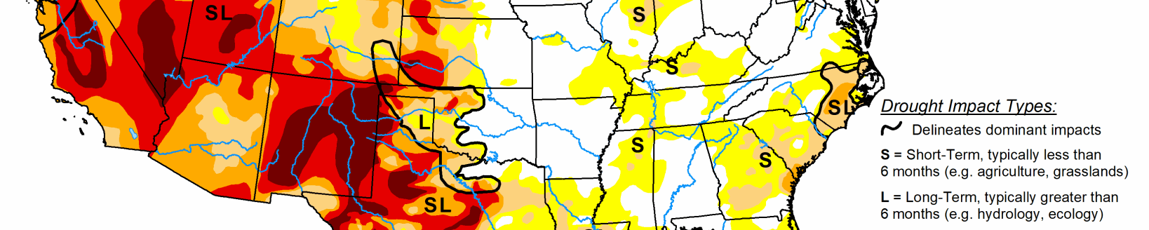
The West generally experienced warmer than normal temperatures again this week, with most areas coming in between 3 and 9 degrees above normal for the week. Generally, the southern half of the region stayed dry, while some precipitation occurred over the north, particularly in far northwest California, western Washington and Oregon, western Wyoming, and western portions of Montana and Idaho. Due to recent precipitation, extreme drought in western Oregon reduced in coverage. In southwest Oregon, where short- and long-term precipitation deficits were worsening, severe and extreme drought increased in coverage. Extreme drought also increased its foothold in west-central Nevada, where soil moisture profiles continued to worsen along with short- and long-term precipitation deficits.
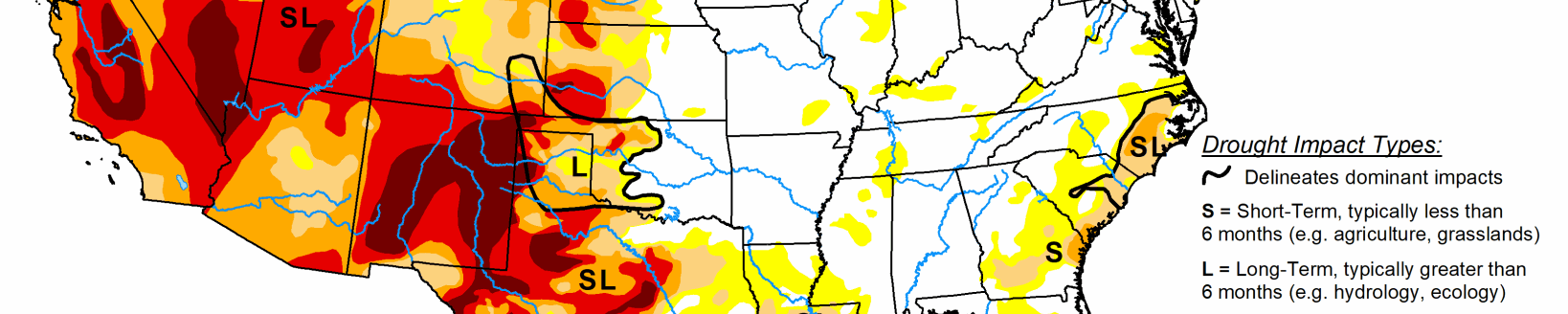
High Plains
Drier than normal conditions continued across much of the High Plains region, where temperatures were also generally 6 to 12 degrees warmer than normal. Consequently, as short- and long-term precipitation deficits grew amid warmer than normal weather, and near surface moisture and agricultural impacts worsened, widespread degradation in drought conditions occurred. Moderate, severe, and extreme drought coverage increased across most of the region, with the exception of northeast Nebraska and adjacent portions of Iowa and South Dakota, where a storm system brought locally high amounts of rain. In the areas with highest rainfall, short-term precipitation deficits improved enough such that extreme and severe drought decreased in coverage.
South
Category two Hurricane Delta and its remnants delivered above-normal rainfall from far east Texas through most of Mississippi, southeast Arkansas, and southern Tennessee, leading to the reduction of abnormally dry areas in Louisiana and Mississippi. Elsewhere, dry conditions occurred, and existing areas of drought expanded. Short-term drought continued to plague the southern high plains regions of Oklahoma and Texas, where moderate, severe, and extreme drought continued to spread amid worsening short-term precipitation deficits, decreasing soil moisture, and drying vegetation. Temperatures in the region were also mostly warmer than normal, with the warmest areas (compared to normal) being found in the Oklahoma and Texas panhandles, where temperatures were 9 to 12 degrees warmer than normal.