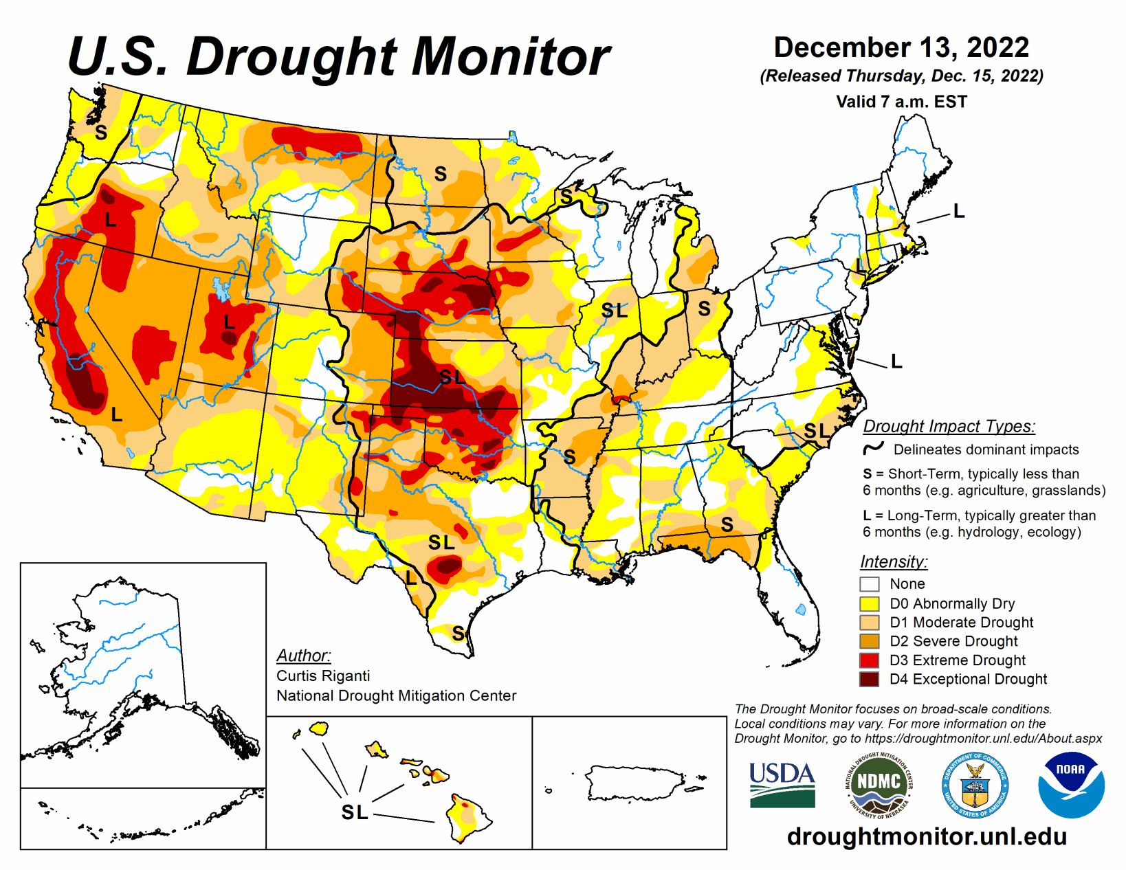
While much of the contiguous U.S. is still experiencing drought or abnormal dryness, several storm systems dropped large amounts of precipitation over the past week in the form of rain or snow, especially in California and from eastern Oklahoma through Tennessee. Since some of this precipitation fell near the Dec. 13 morning data cutoff, more analysis of the early week precipitation will be performed next week, when more data is available to analyze changes to ongoing drought conditions. In parts of the Great Lakes, Southeast, and northwest Kansas that missed out on recent precipitation, drought or abnormal dryness developed or worsened.
South
In northern parts of the region, from central and eastern Oklahoma eastward through Tennessee, widespread moderate to heavy rain fell, leading to widespread improvements to ongoing drought and abnormal dryness. In central Oklahoma and north Texas, given that some of this rain fell near the data cutoff, more changes may be made next week as more data becomes available.
Wetter recent weather led to improvements in surface conditions and precipitation deficits in central and west-central Texas, leading to some improvements in ongoing drought there. Due to recent heavy rainfall, severe drought areas in southwest Arkansas and near the Louisiana/Mississippi border were removed. A few localized spots in the eastern half of Texas saw conditions worsen after missing out on recent rains. Most of the region saw above-normal temperatures this week, with large portions of central and eastern Texas, Louisiana, and Mississippi seeing readings at least 15 degrees above normal.
Midwest
Conditions varied widely across the Midwest region this week. Short-term dryness continued in parts of Indiana, Ohio, and Illinois, where recent precipitation mostly missed to the south and west before Tuesday morning. Severe short-term drought developed in southeastern parts of the Michigan Lower Peninsula, where soil moisture and precipitation deficits mounted, and reports of groundwater problems emerged. Meanwhile, in the southern tier of the region, from southern Missouri eastward through Kentucky, widespread moderate to heavy rain led to widespread improvements to ongoing drought and abnormal dryness, with most of southwest Missouri and almost all of Kentucky seeing a one-category improvement to conditions.
An early-week storm system deposited both rain and frozen precipitation in Iowa and other parts of the Upper Midwest near the Tuesday morning data cutoff. A small reduction in extreme drought coverage was made just northeast of Sioux City, Iowa, where higher amounts of precipitation fell. Across the rest of the region that experienced significant precipitation on Monday night and Tuesday, further analysis will occur next week. More improvements may be made next week if the wider suite of data is supportive when it becomes available.
High Plains
Heavier rains accumulated Monday night into early Tuesday in parts of southeast Kansas, leading to some improvements in the drought situation there as precipitation deficits lessened. Dry weather continued in parts of northwest Kansas, where soil moisture deficits and long-term precipitation deficits continued to worsen. A few small changes (one improvement and one degradation) were made in southeast Colorado and adjacent northeast New Mexico, where surface conditions changed in tandem with recent precipitation or lack thereof. Elsewhere, conditions did not change much across the region.
Snow and rain that fell Monday night and Tuesday morning from northeast Colorado into Nebraska and southern South Dakota will be analyzed further next week for possible improvements to ongoing drought. Temperature anomalies for the week varied from north to south across the region, with below-normal temperatures occurring in most of North Dakota, while near- or slightly above-normal temperatures were more common in Colorado and Kansas.
West
Widespread improvements to ongoing drought occurred across parts of the West region this week, due to copious amounts of rain or snow. Hefty rainfall amounts in some of the coastal mountain ranges of California caused high streamflow, which lessened precipitation deficits and led to localized improvements. Widespread improvements occurred in parts of the central Sierra Nevada range, where heavy snow fell and added to a healthy early-season snowpack. Temperatures across the West region were generally near or a bit below normal, with the exceptions of New Mexico and eastern Montana, which had above- and below-normal temperatures, respectively.