Major Hurricane Ian made landfall in southwestern Florida on Sept. 28 and then reemerged offshore of the Atlantic coast, with another landfall near Georgetown, South Carolina, two days later. Excessive rainfall (more than 10 inches) caused widespread inland flooding throughout the central Florida Peninsula and heavy rainfall overspread the Carolinas, Mid-Atlantic, and central Appalachians.
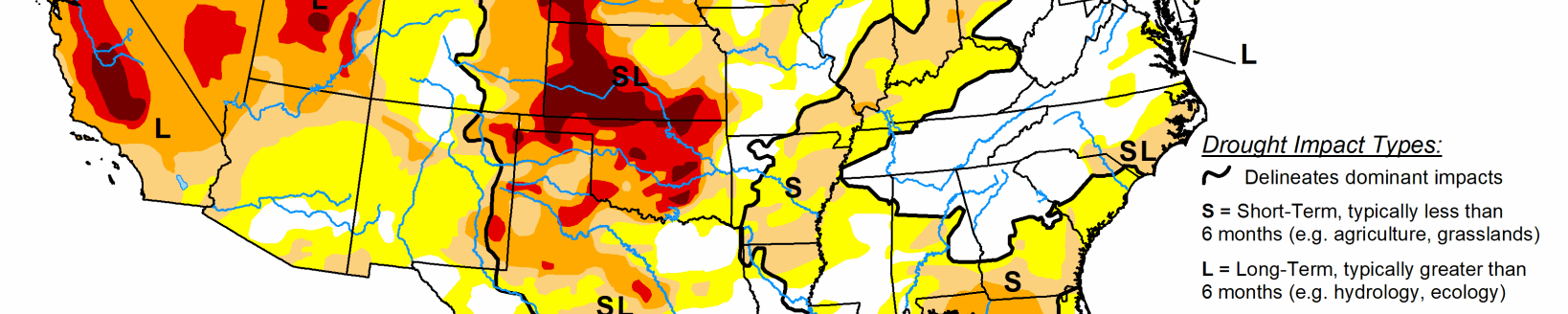
After a mid-level low pressure system tracked inland from the northeastern Pacific and became stationary over the interior West, heavy precipitation (1 to 3 inches) occurred across northern Idaho along with the north-central Rockies. Therefore, improvements were made across much of the East and north-central Rockies. Conversely, a dry week resulted in an expansion of abnormal dryness (D0) and moderate drought (D1) along with intensifying drought conditions across much of the Great Plains, Mississippi Valley, and Midwest. D1 was added to parts of the Pacific Northwest. A mix of improvements and degradations were made to Hawaii, while Alaska and Puerto Rico remain drought-free.
South
Due to a very dry pattern during the past month along with periods of above-normal temperatures, a 1-category degradation was necessary for parts of the Ozarks, lower Mississippi Valley, western Gulf Coast, and southern Great Plains. 30-day precipitation deficits exceed 4 inches in eastern Oklahoma and northwestern Arkansas. Much of these areas along with interior portions of southeastern Texas have received less than 0.10 inch of rainfall during the past 30 days. 30-day SPI/SPEI along with NLDAS and NASA SPoRT soil moisture were the primary indicators used in depicting these degradations along with recommendations from regional partners.
Low to dry ponds, poor pastures, and cattle selloffs continue to be major impacts for Arkansas and Oklahoma. Although moderate drought (D1) was added to southwestern Louisiana, a broader D1 coverage was not designated this week due to a strong wet signal at 60 days and lack of support from soil moisture indicators. A couple of small D1 areas were added to Tennessee (near Nashville and northeast of Chattanooga), based on SPI/SPEIs and declining soil moisture.
Midwest
Increasing short-term precipitation deficits, periods of above-normal temperatures, and rapidly declining soil moisture indicators support widespread 1-category degradations throughout a majority of Missouri and parts of Iowa. 30 to 60-day precipitation deficits resulted in an expansion of abnormal dryness (D0) across southwestern Wisconsin and moderate drought (D1) across northern Wisconsin. Based on 30 to 60-day SPIs and support from soil moisture indicators, a slight expansion of D0 and D1 was warranted for southern and eastern parts of Lower Michigan.
High Plains
Short and long-term NDMC blends, SPIs, soil moisture, and crop conditions support a 1-category degradation for southern South Dakota, southwestern Nebraska, and parts of Kansas. Pond levels are low in Kansas and limited soil moisture is available for winter wheat planting. Abundant recent precipitation (locally more than 2 inches) prompted improvements along the western slopes of the Colorado Rockies. Improvements were also made to northeastern Colorado due to relatively significant precipitation (more than 0.5 inch) this past week. Following heavy precipitation during early August, little to no rainfall for a six-week period resulted in an increase in D1 across southeastern Colorado. Beneficial precipitation during the past 30 to 60 days along with improving soil moisture conditions prompted improvements across parts of Wyoming.
West
Late summer heat and increasing 90-day precipitation deficits of more than 6 inches resulted in the addition of short-term moderate drought (D1) to parts of northwest Oregon and western Washington. This new D1 area is supported by 30 to 120-day SPI values, near record low 28-day streamflows for this time of year, and declining soil moisture. Conversely, heavy precipitation (1 to 4 inches) supported a broad 1-category improvement across parts of west-central Montana and the impact was changed from SL to L only. The 12- to 24-month SPI values continue to support D1+ throughout western Montana. Based in part on above-normal temperatures during August and September, 1-category degradations were made to parts of southern Idaho. Farther to the north, beneficial precipitation during the past week resulted in a 1-cateogry improvement to northern Idaho. Although Arizona and much of New Mexico were status quo this week, this region will be reevaluated next week as many areas received more than 0.5 inch of rainfall from Sept. 27 to Oct. 3 and it was a wet Monsoon for the Southwest.
Related Articles