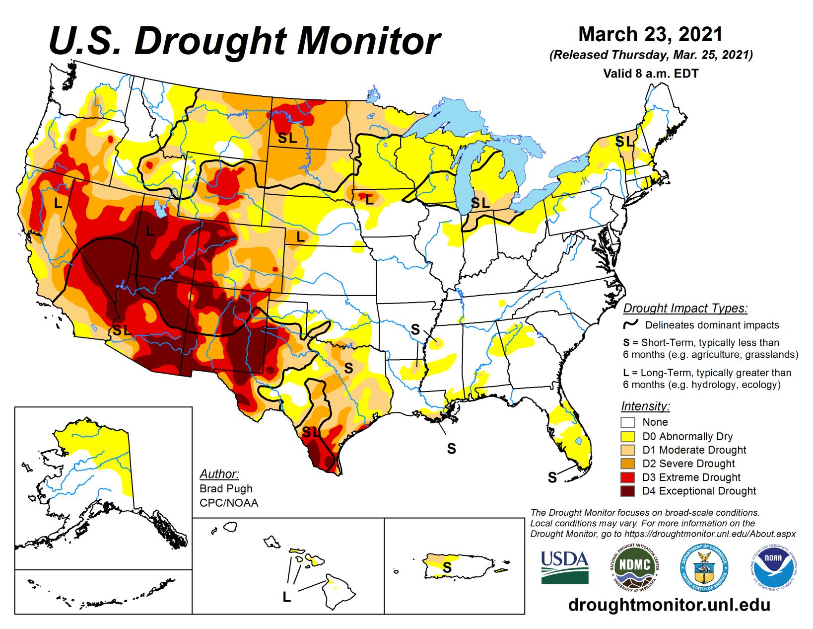
A couple of low pressure systems resulted in widespread precipitation (0.5 to 3 inches, locally more) across the central and southern Plains, Ohio and Tennessee Valleys, Southeast, and Mid-Atlantic from March 16 to 22. However, mostly dry weather persisted across southern Texas, the Florida Peninsula, northern New England, the Great Lakes, and northern Plains. Periods of rain and high-elevation snow occurred across the Pacific Northwest, northern California, and the central Rockies, but the Southwest remained mostly dry. As of March 23, 7-day maximum temperatures averaged above normal across the northern Plains and Upper Mississippi Valley.
Midwest
Widespread precipitation (0.5 to 2 inches) fell from Missouri east to Kentucky, Illinois, Indiana, and Ohio on March 17 and 18. This recent precipitation maintained saturated soils, high streamflows, and minor to moderate river flooding across the Middle Mississippi Valley and Lower Ohio Valley. In areas that were drier preceding this precipitation, extending from northeast Missouri east to Ohio, a large decrease in D0 (abnormal dryness) and D1 (moderate drought) coverage was warranted. However, this recent rainfall had to be balanced with longer term SPIs. There was a sharp northward cutoff to this precipitation and D0-D1 coverage was increased across lower Michigan, extreme northern Indiana, and southern Wisconsin based on soil moisture and SPI values at various time scales.
High Plains
Frequent precipitation during the past two weeks continues to result in additional improvements to parts of the central Plains and central Rockies. 7-day total amounts (March 16-22) ranged from 1 to 3 inches, locally more, across a broad region including south-central Nebraska and much of Kansas. As of March 22, Grand Island Nebraska has received 6.95” so far this month, which makes it the wettest March on record. The drought amelioration extends west to the central Rockies where numerous improvements were made including a two-category change from D3 to D1 in southwest El Paso County and southeast Teller County as SPIs are now D1 at all timescales. The removal of D3 in southeast Colorado and southwest Kansas was based on: SPIs are either neutral or positive dating back to 6 months and improving soil moisture conditions. In contrast to the major improvements across the central Rockies and central Plains during the past two weeks, persistent dryness continues to support additional expansion of D2 (severe) and D3 (extreme) drought across parts of North Dakota.
West
A slight expansion of severe drought (D2) was made to northeast Montana, based on 90-day SPI and soil moisture below the 10th percentile. These low soil moisture conditions are related to the lack of snowfall this winter. In contrast to the northern high Plains, snow water content is running close to average for late March and led to the elimination of abnormal dryness (D0) across south-central Montana. Since parts of western Arizona and southeast California have received little to no precipitation during the past two month, D3 (extreme) and D4 (exceptional) drought were slightly increased. This expansion of D3-D4 was supported by 9-month SPI values, which covers the failed 2020 monsoon and this past winter. An expansion of D2 (severe) and extreme (D3) drought across parts of southern California was based on large water year to date precipitation deficits and 6-month SPI values. No other changes were made at this time to the remainder of California as 6 to 12 month SPIs generally support the current depiction and snow water content is running near two-thirds of average for the Sierra Nevada Mountains. During subsequent weeks, the drought depiction will be reassessed across California. Although much of the precipitation this past week fell along the coast or over the Cascades, a reassessment of longer term SPIs dating back 6 to 12 months supported removal of the D2 (severe) drought in southwest Oregon. Due in part to recent high-elevation snow and rainfall during the past two weeks, a slight decrease in D3 (extreme) and D4 (exceptional) drought was made to northern and northeast New Mexico. However, widespread D4 persists across southeast New Mexico where dust storms have been quite frequent this month and soil moisture remains in the lowest one percentile.
South
The severe weather outbreak that affected the Southeast Region began across the Lower Mississippi Valley on March 17 and local rainfall amounts exceeded 2 inches across parts of Arkansas, Louisiana, and Mississippi where 1-category improvements were made. More widespread rainfall amounts of more than 1.5 inches increased soil moisture throughout nearly all of Tennessee. Based on this past week’s rainfall of 1 to 3 inches and improving soil moisture conditions, improvements were made to much of Oklahoma and parts of northern to central Texas. Small 2-category improvements were justified for the northeast Texas Panhandle and northwest Oklahoma where the heaviest rainfall occurred. Periods of above normal temperatures, enhanced surface winds, and below normal precipitation this month supported a continued worsening of drought conditions throughout southern Texas. Soil moisture declines rapidly from central to west Texas where indicators support D3 (extreme) to D4 (exceptional) drought categories.


