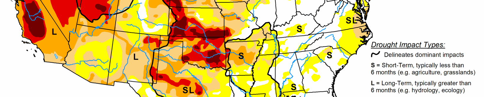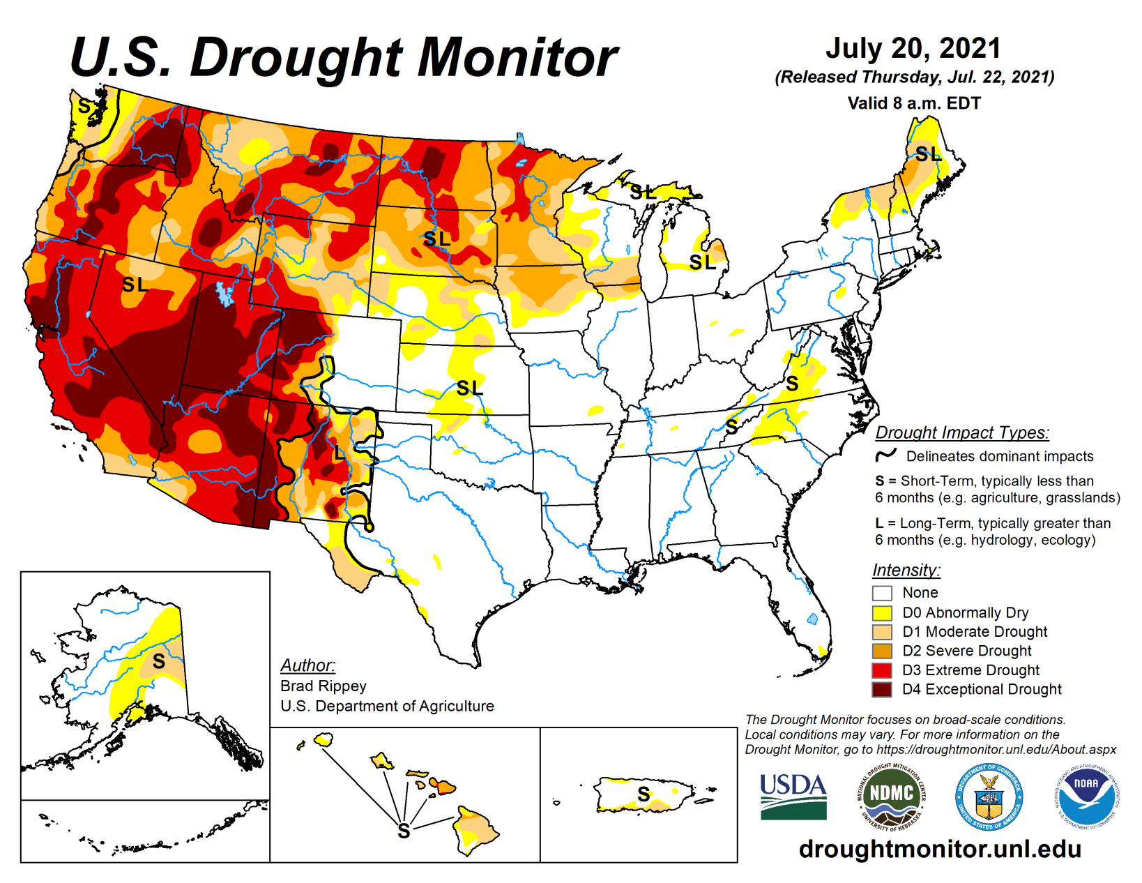
Active weather prevailed across much of the South, East, and Midwest, as well as parts of the Plains, into the middle of July, followed by a southward shift in widespread shower activity. Meanwhile, a robust monsoon circulation provided limited Southwestern drought relief, particularly in parts of Arizona, New Mexico, and southwestern Colorado.
In the driest areas of the northern and western United States, drought’s impact on water supplies, as well as rangeland, pastures, and a variety of crops, was further amplified by ongoing heat. Weekly temperatures averaged as much as 10°F above normal from the interior Northwest to the northern High Plains. On July 19, temperatures as high as 110°F were reported in eastern Montana. Another pocket of hot weather was centered over the middle Atlantic States. In contrast, near- or slightly below-normal temperatures dominated the Plains, Midwest, and South.
South
Patches of dryness (D0) and moderate drought (D1) have been relegated to a few areas in Oklahoma, Tennessee, and Texas. Broadly, there are few drought-related impacts in the South. Frequent summer rain events have maintained adequate to abundant soil moisture. On July 18, Mississippi led the region with topsoil moisture rated 33% surplus, according to the U.S. Department of Agriculture.
Midwest
An axis of heavy rain stretched from southern Missouri to northern Ohio. Secondary areas of locally heavy showers extended from Iowa and southeastern Minnesota to Michigan. The Midwestern rain intersected some existing areas of dryness (D0) and moderate to extreme drought (D1 to D3), resulting in some reductions in coverage. Some of the most dramatic improvements occurred across central Wisconsin and northern Lower Michigan. From July 13-15, more than 2 inches of rain soaked La Crosse, Wisconsin, and Traverse City, Michigan. Oshkosh, Wisconsin, received 3.34 inches.
In contrast, little or no rain fell during the drought-monitoring period around Lake Superior and in central and northern Minnesota, where coverage of severe to extreme drought (D2 to D3) was greatly expanded. A broad array of indicators and indices, including streamflow, soil moisture, the Vegetation Health Index, the Evaporative Demand Drought Index, and the Standardized Precipitation Index, have shown that very serious drought conditions exist at a variety of times scales across much of northern and central Minnesota. On July 18, Minnesota led the Midwest with 63% of its pastures rated in very poor to poor condition, along with 42% of its spring wheat, 34% of its oats, 33% of its barley, 18% of its corn, and 17% of its soybeans. Minnesota also led the Midwest on that date, according to the U.S. Department of Agriculture, with topsoil moisture rated 78% very short to short.
High Plains
Scattered showers largely ended early in the drought-monitoring period. Meanwhile, extreme heat returned across northern portions of the region. Agricultural drought impacts across the northern High Plains remained widespread and severe, despite spotty showers. According to the U.S. Department of Agriculture, topsoil moisture on July 18 was rated 86% very short to short in North Dakota, along with 84% in South Dakota and 74% in Wyoming. Rangeland and pastures were rated at least one-half very poor to poor in Wyoming and the Dakotas, led by South Dakota at 78%.
On July 18, North Dakota was the national leader in oats rated very poor to poor (50%; tied with South Dakota), along with soybeans (41%) and corn (32%). South Dakota led the nation, among major production states, in sorghum rated very poor to poor (29%). Nationally, the U.S. spring wheat crop was rated just 11% good to excellent and 63% very poor to poor on July 18, the lowest overall condition at this time of year since July 18, 1988, when the crop was categorized as 7% good to excellent and 73% very poor to poor. Initial estimates released by USDA on July 12 indicated that the 2021 U.S. spring wheat production will be down 41% from last year, while yield will be down 37%. If realized, the 2021 U.S. spring wheat yield of 30.7 bushels per acre would be the lowest since 2002.
West
Showers associated with the Southwestern monsoon circulation provided limited drought relief in Arizona, New Mexico, and southwestern Colorado, while drought generally worsened across the northern Rockies and interior Northwest. The Western drought continued to act on multiple time scales, ranging from a few weeks (mostly agricultural impacts) to two decades (ecological and hydrological effects).
Dozens of wildfires, primarily across northern California and the Northwest, continued to burn through hundreds of thousands of acres of timber, brush, and grass, aided by hot, dry conditions, dry soils, and ample fuels. Wildfire smoke continued to degrade air quality in many areas of the country, well outside the West. In southern Oregon, the nation’s largest active wildfire—the lightning-sparked Bootleg Fire—has consumed more than 394,000 acres of vegetation and has destroyed at least 184 structures. Meanwhile, Washington led the country in several drought-related agricultural categories, according to the U.S. Department of Agriculture.
Moving to longer-term impacts, some of the West’s largest reservoirs and lakes continued to exhibit startling declines. The surface elevation of Lake Mead, on the Colorado River behind Hoover Dam, fell 135 feet in the 21-year period from July 1, 2000, to July 1, 2021, from 1,204 to 1,069 feet above sea level. By July 20, Lake Mead’s elevation stood at 1067.79 feet. Prior to the 21st century, Lake Mead’s surface elevation briefly fell below 1,100 feet only during two drought periods: 1955-57 and 1964-65. Since March 2014, the lake’s end-of-month surface elevation has been continuously below 1,100 feet—and currently stands at a record low since impoundment occurred more than 80 years ago. Farther upstream, water is being released from Flaming Gorge Reservoir in Wyoming and Utah to boost the level of Lake Powell for the purpose of guarding hydropower generating capability. Elsewhere in Utah, the surface elevation of the Great Salt Lake fell to 4,191.4 feet on July 20, tying the previous record low set in 1963. In California, 154 primary intrastate reservoirs gained just 1.7 million acre-feet of water during the 2021 melt season, barely 20% of the historical recharge average of 7.9 million acre-feet. At the end of June, the 154 reservoirs held just 62% of their typical volume for this time of year—and had lost 16.6 million acre-feet of water (49% of the original volume) over the last 2 years. Current California storage (17.5 million acre-feet) is less than 5.8 million acre-feet above what those reservoirs held on June 30, 1977, which was the year when statewide storage ultimately fell to a record-low end-of-month volume of 7.5 million acre-feet at the end of October. Finally, the punishing Western drought has been accompanied by record-setting high temperatures. The most recent northward shift in heat occurred as monsoon-related showers intensified across the Southwest. By July 19, Glasgow, Montana, reported a maximum temperature of 110°F—the highest reading in that location since July 18, 1936. It was also Glasgow’s third-highest temperature (tied with June 17, 1933) on record, behind only 113°F on July 31, 1900, and 112°F on July 18, 1936.