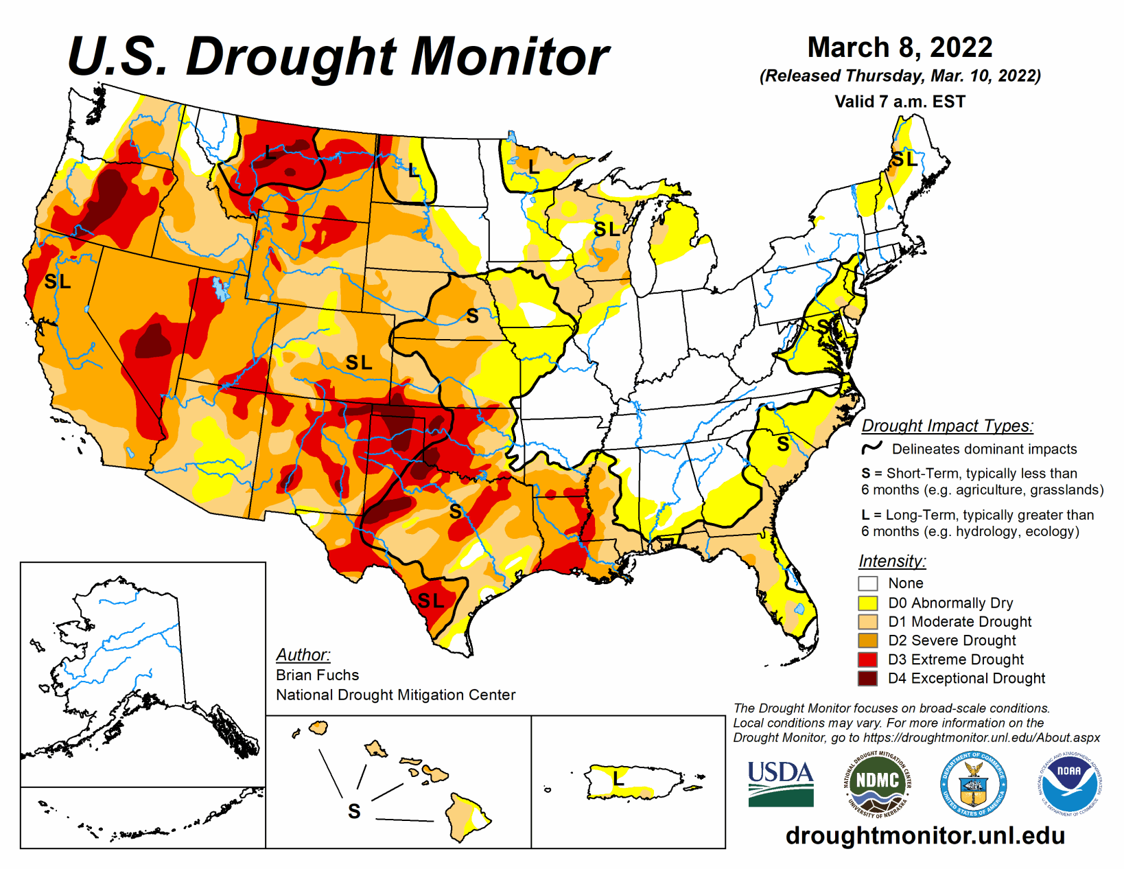
Several storm systems from the northern Rocky Mountains to the Midwest brought with them rain, snow, and even some severe weather this past week. Temperatures for the week were cooler than normal over the northern Plains and into the West. The coldest readings were in the northern Plains and upper Midwest, with departures of up to 9 degrees below normal.
Areas of the Midwest, central Plains and into the West did see above-normal precipitation this week with areas of Kentucky, Indiana, and Ohio receiving over 2 inches of precipitation during the period. The southern Plains and South continue to dry out. As spring approaches and dormancy is broken, impacts are already showing in these areas and drought intensification is widespread with quickly expanding extreme and exceptional drought areas.
South
Temperatures were warmer than normal over most of the region, with departures of 9-12 degrees above normal over Tennessee. Areas of northern Oklahoma and Arkansas experienced the only precipitation events in the region with above-normal amounts as most all of the region was quite dry. Degradation continued with drought status over the region. As dormancy breaks and green-up begins, water demand has increased along with warmer temperatures. Exceptional drought was expanded to cover more of the Oklahoma and Texas panhandles. Severe drought was expanded over western Oklahoma along with a new pocket of exceptional drought.
A full category worsening of drought conditions took place over west Texas and much of central and east Texas as severe and extreme drought expanded. Mississippi and Louisiana also had widespread degradation with extreme drought expanded over most of southern Louisiana and along the Mississippi River into Mississippi.
Moderate and severe drought were also expanded over much of central Mississippi and into southeast Louisiana. The overall pattern from the southern Plains into the South has been dry and warm conditions that will only lead to worsening conditions as spring arrives. The 4-month period from November to February was the second driest such period for Louisiana since 1895 with less than 10 inches of observed precipitation statewide. With some good rains in Louisiana after the data cutoff for consideration this week, there may be some opportunities for improvements next week where the greatest rains occur.
Midwest
Temperatures in the region were warmer than normal in the south, with departures of 9-12 degrees above normal, and cooler than normal in the north, with departures of 3-6 degrees below normal. Widespread precipitation over the region was recorded with many areas over 200% of normal for the week. With widespread precipitation, it was possible to show some improvements to drought conditions this week. Abnormally dry conditions were improved in south central and northeast Iowa, southwest Missouri, central Wisconsin and central Minnesota. Moderate drought was also eased in Minnesota and Wisconsin, but both states have some concerns with long-term drought.
High Plains
Precipitation was mixed in the region as portions of Wyoming, South Dakota, Nebraska, and Kansas recorded rain and snow during the week, with the winter season being quite dry overall. Temperatures were cooler than normal over the Dakotas and into western Nebraska and Wyoming with temperatures 2-4 degrees below normal.
Eastern Nebraska and most of Kansas were warmer than normal with departures of 5-7 degrees above normal. Most of the region did not have any changes this week due to the lingering dryness. Kansas did have some drought intensification with severe drought expanded over the north central part of the state and along the Oklahoma border. With long-term dryness over southwest Kansas, exceptional drought was expanded out of the southern Plains and into southwest Kansas. Extreme southeast Kansas did record enough precipitation for improvement to abnormally dry and moderate drought conditions.
West
Cooler than normal temperatures were common over the region with departures of 2-4 degrees below normal over much of the West. Some precipitation in the Rocky Mountains, central Utah and Nevada as well as the Pacific Northwest did help with seasonal snow values, reversing a dry trend that most areas have had. In California, there are many who fear that the snowpack has peaked for this season at 61% of normal, which will lead to further drought issues later on. Improvements were made to moderate drought and abnormally dry conditions in northern Idaho and western Montana. Northern Oregon had improvements to severe and extreme drought as well as to abnormally dry conditions. Extreme drought was expanded over portions of southern Oregon.
Extreme drought was improved over northwest Colorado as both short- and long-term conditions were improving. A small area of moderate drought was improved over eastern Wyoming while moderate and severe drought were expanded over portions of southern Idaho. The dryness in the southern Plains is also impacting portions of southern and eastern New Mexico, where drought intensified this week. A new pocket of exceptional drought was added in southwest New Mexico while moderate and severe drought expanded in southern New Mexico and extreme drought expanded over eastern New Mexico.