Portions of southwest Kansas had their driest October on record, expanding extreme and exceptional drought
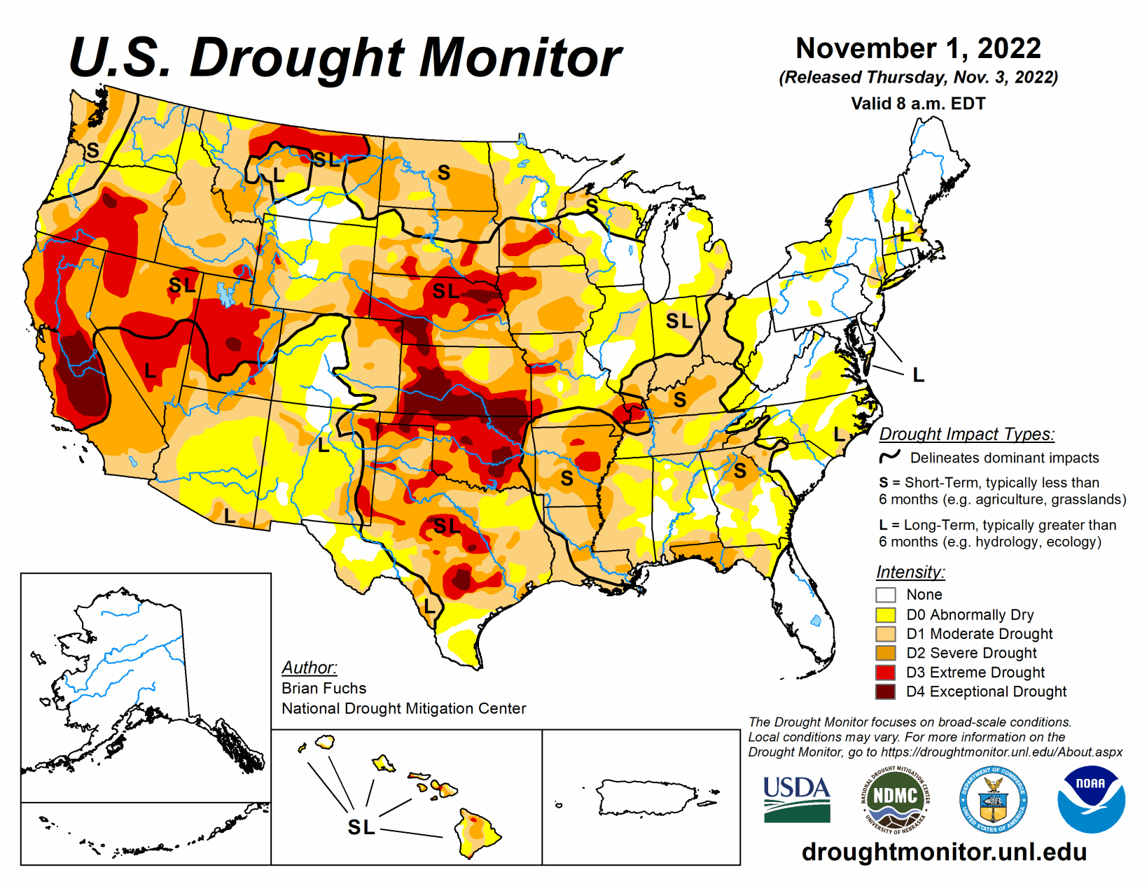
An active weather pattern over the Midwest to southern Plains brought the most precipitation to those areas this week. Warm and dry conditions dominated the northern Plains and the upper Midwest where some areas are experiencing “flash drought” conditions that are not as common this time of year.
South
Welcome rains over north and south Texas, Arkansas, northern Louisiana and into southern Oklahoma helped to build on recent precipitation events in some of these areas. Portions of north Texas and into southern Arkansas and northern Louisiana recorded 200% to 400% of normal precipitation for the week. Southern Louisiana as well as west Texas and the Oklahoma panhandle remained dry.
Cooler than normal temperatures through much of Texas and Oklahoma as well as western Arkansas and Louisiana helped to slow down further drought development for this week and even allowed for some improvements. A full category improvement to drought levels was made over northern Texas and into southeast Oklahoma. In Arkansas, extreme and severe drought were improved. Additional improvements were made to moderate and severe drought in east Texas and to abnormally dry conditions in south Texas.
Midwest
The Midwest had a stark contrast in precipitation for the week with the northern and western portions quite dry, the central areas quite wet, and the eastern areas dry. The greatest precipitation was recorded from central and eastern Missouri into Illinois and western Indiana where over 300% of normal precipitation was recorded. Temperatures remained mild in the region with almost all areas above normal for the week, outside of some areas of Missouri and Illinois where rains kept the temperatures below normal. Northern Minnesota had temperatures 6 to 8 degrees above normal while the eastern portions of the region were 2 to 4 degrees above normal.
Missouri had the most improvements as rains over the current period as well as the last few weeks allowed for a full category of improvement in central and eastern portions of the state. Degradations were made in Iowa and Minnesota where severe drought expanded over western Iowa and extreme drought expanded over southern Minnesota and northwest Iowa. Abnormally dry and moderate drought also expanded over portions of northern and eastern Minnesota as well as southeast Iowa.
High Plains
Temperatures were well above normal over the northern and eastern portion of the High Plains and below normal in the west. Temperatures were 8 to 10 degrees above normal in the Dakotas and 2 to 4 degrees above normal in Nebraska and northern Kansas. Portions of Wyoming, Colorado and western Nebraska were cooler than normal with temperatures 2 to 4 degrees below normal.
It was quite the dry week in the region as there were only a few pockets of rain in southeast South Dakota, northeast Nebraska and into north-central Kansas. Flash drought conditions are impacting the region, especially in the Dakotas where warm, dry and windy conditions have provide ideal harvest conditions but have started taking a toll on the region.
In the Dakotas, a broad expansion of severe drought conditions took place this week. Moderate drought also expanded in eastern South Dakota and into southern portions of the state. Continued dryness over Kansas, where portions of southwest Kansas had their driest October on record, allowed for the expansion of extreme and exceptional drought this week. On the plains of Colorado, moderate drought and abnormally dry conditions continue to expand.
West
Temperatures for the week were cooler than normal over most of the region, with departures of 4 to 6 degrees below normal over the southwest. Warmer than normal conditions were recorded in the Pacific Northwest as well as across the northern portion of the region where temperatures were 4 to 6 degrees above normal with some even greater departures in Montana. Wetter than normal conditions were recorded in the Pacific Northwest as well as in western Colorado, northern Oregon, and into northern Idaho.
The continued wet pattern allowed for some improvements in northeast New Mexico to the moderate, severe, and extreme drought conditions even as long-term issues remain. Western Colorado had improvements to moderate and severe drought as the ongoing wet pattern and early snows have allowed for improvements. Washington received enough rain to start showing improvements to the moderate and severe drought in the west while northern portions of the state had moderate drought expand.