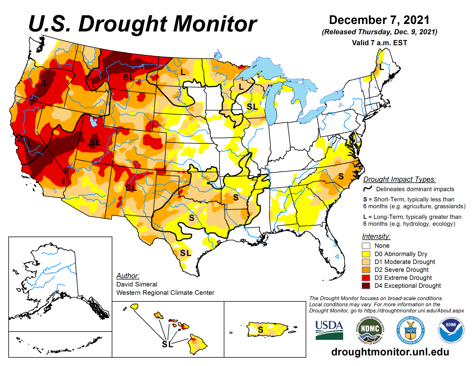
This U.S. Drought Monitor week saw continued deterioration in conditions across areas of the Mid-Atlantic (Virginia, North Carolina) and the Southeast (South Carolina, Georgia) in response to below-normal precipitation (past 30- to 90-day period), declining soil moisture and streamflow levels. Likewise, drought-affected areas expanded and intensified on the map in areas of the South including Louisiana, Arkansas, and Texas as well as in the Southern Plains of Oklahoma, where overall warm and dry conditions have prevailed during the past 30- to 120-day period.
Across areas of the Northern Plains, Upper Midwest, and the Northeast, light-to-heavy snowfall accumulations were observed during the past week. The heaviest accumulations (8 to 18 inches) were centered on northern portions of Minnesota, Wisconsin, and Michigan, while lake-effect snowfall (2 to 8 inches) impacted areas downwind of Lake Erie and Lake Ontario in New York, according to snowfall analysis from the National Weather Service National Operational Hydrologic Remote Sensing Center.
Out West, some areas including the North Cascades, Sierra Nevada, and the Northern and Central Rockies, received much-needed snowfall this past week. However, basin-level snowpack conditions remained below normal across the entire western United States. In terms of fall precipitation, the driest conditions were observed across parts of the Southwest, Texas, Montana, Wisconsin, and the Carolinas.
South
For the week, the region was mainly dry with average temperatures that were well above normal (6 to 15 deg F). Some light precipitation (1 to 2 inches) was observed in areas of central Louisiana, Mississippi, and western Tennessee. On the map, conditions degraded across much of the region including Texas, Oklahoma, Louisiana, and Arkansas where areas of Moderate Drought (D1) and Severe Drought (D2) expanded in response to persistent warm and dry conditions. In the western portions of Oklahoma and Texas, the NASA Crop-CASMA application is showing significant negative soil moisture anomalies this month. In the Rolling Plains of Texas, some drought-related impacts have been reported, including reports of winter wheat crops continuing to struggle due to the lack of moisture.
Midwest
On this week’s map, only minor changes were made on the map in Missouri where precipitation has been below normal during the past 90-day period. Light precipitation accumulations were observed this week in the greater Ohio River Basin (1 to 2 inches) as well as in the northern portions of the Midwest where locally heavy snowfall amounts were observed. According to NOAA NOHRSC, 67% of the Northern Great Lakes region was covered by snow with an average depth of 3.8 inches and a maximum depth of 19.5 inches on December 8. Average temperatures for the week were mainly above normal with the largest anomalies observed in the southern and western portions of the region, where temperatures were 6 to 12+ degrees above normal.
High Plains
On this week’s map, areas of the region—including the eastern plains of Colorado—saw widespread degradation in response to anomalously warm temperatures, short-term precipitation deficits, declining soil moisture levels, and elevated evaporative demand across the region. Moreover, impact reports from eastern Colorado are yielding concerns by producers about winter wheat stands as well as declining pasture and range conditions.
According to the latest USDA Colorado Crop Progress report, the percentage of topsoil rated short to very short was 84%, while pasture and range conditions were rated 40% very poor to poor. For the week, most of the region was unseasonably warm and dry with average temperatures ranging from 2 to 12 degrees above normal with the greatest departures observed in eastern portions of Colorado and Wyoming, Kansas, and Nebraska. In eastern Colorado, average maximum temperatures for the week ranged from 60 to 70 degrees.
West
In the West, the big story continues to be the poor snowpack conditions across the region and growing concern about water supplies after back-to-back dry winter seasons in California as well as in other basins including the Colorado River Basin. In California, the Department of Water Resources announced (December 1) that the State Water Project’s initial water allocation for 2022 will be at 0% in an unprecedented step to address the state’s water supply in anticipation of another dry winter season.
Other impacts of concern across the region include the delayed opening of ski areas across the region, which is impacting local economies in mountain communities across the West. However, some positive signs have emerged over the past week and looking ahead in the short-term with a change to a more active weather pattern for the region with heavy mountain snowfall expected in the Cascades, Sierra Nevada, Great Basin, and the Rockies. On the map this week, recent precipitation in the Pacific Northwest led to improvements in drought-affected areas of Washington as well as in northeastern Oregon, and west-central Idaho. Conversely, an area of Extreme Drought (D3) expanded in southwestern Montana due to poor snowpack conditions in the higher elevations.
Related Articles