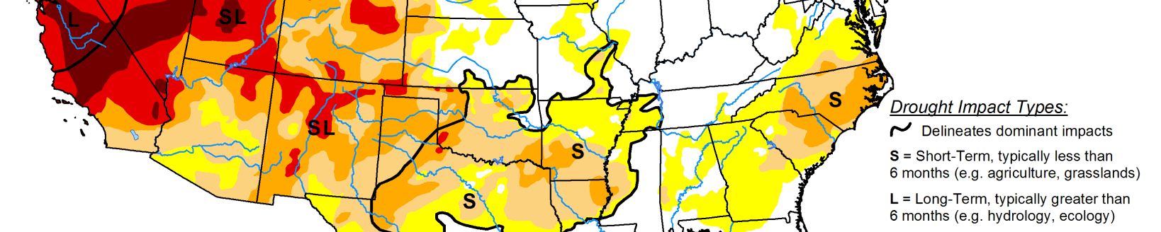
Some areas see modest improvements in drought conditions
This U.S. Drought Monitor week saw some modest improvements in drought conditions across portions of the Southwest, southern Great Plains, South, lower Midwest, and portions of the Northeast. Drought-related conditions deteriorated in southern California, the southern Great Basin, Texas, Minnesota, and parts of New England.
Elsewhere, above-normal precipitation during the past 30-to-60-day period and snowfall this week in northern portions of the Texas Panhandle and Oklahoma Panhandle led to removal of areas of drought. Further to the south in the Hill Country and South Texas Plains, drought intensified in response to persistent warm and dry conditions as well as mounting precipitation deficits ranging from 2-to-8+ inches during the past 90-day period. Conversely, areas along the coastal plains of northeastern Texas received 1-to-2+ inch accumulations during the past week leading to widespread improvements on the map. In the Midwest, wetter-than-normal conditions during the past 30-to-60-day period led to minor improvements on the map in central Illinois and northern Indiana.
High Plains
On this week’s map, areas of the region—including southwestern Kansas and northeastern Wyoming—saw modest improvements including reduction in areas of Severe Drought (D2) in Wyoming and areas of Moderate Drought (D1) in southwestern Kansas where recent snowfalls have helped to improve local conditions. Average temperatures for the week were near to slightly above normal across most of the region with eastern portions of the region observing the greatest positive temperature anomalies ranging from 3-to-12 deg F above normal. According to the NOAA NOHRSC, the Upper Midwest Region was only 16.4% covered in snow (a reduction from 30.3% last month) with an average depth of 0.2 inches and a maximum depth of 30.5 inches. Field reports from the USDA NASS North Dakota Crop Progress and Condition Report (Nov. 30) yielded winter wheat conditions rated as 4% very poor, 5% poor, 50% fair, 39% good, and 2% excellent.
West
During the past week, areas of the West received much needed rain and snow over the weekend with mountain snow observed in the Cascades, Sierra Nevada, ranges of central/eastern Nevada, the Uinta Mountains, and across areas of the Rockies from Montana to New Mexico. Snowfall accumulations ranged from 6-to-24+ inches in the higher elevations. In the California mountains, the current statewide soil water equivalent (SWE) for the date (Dec. 14) is 47% of normal—up 11% since last week. In northern New Mexico, some minor improvements were made on the map in the Sangre de Cristo Range near Taos where soil moisture levels improved (according to NASA SPoRT) and snowfall during the past week bumped a few SNOTEL stations (Gallegos Peak, Tolby) above normal levels for the date. In southeastern Idaho, areas of Moderate Drought (D1) were reduced in response to several SNOTEL sites (Prairie, Camas Creek Divide) reporting above-normal SWE.
South
On this week’s map, areas of drought intensified and expanded in the Hill Country and South Texas Plains where warm and dry conditions continued this week. In these areas, 90-day precipitation deficits ranged from 2-to-8 inches, and current soil moisture levels were below normal according to the NASA SPoRT soil moisture monitoring products. According to Water Data for Texas (Dec. 16), monitored water supply reservoirs are currently 79.9% full—with reservoirs in the eastern half of the state ~80–90% full while reservoirs in the western half of the state were generally <40% full. In the far northern portions of the Texas Panhandle and Oklahoma Panhandle, conditions improved on the map in response to short-term precipitation including snowfall observed during the past week with accumulations ranging from 1-to-8+, according to NOAA NOHRSC. In eastern portions of Texas, northwestern Louisiana, and southeastern Oklahoma, precipitation during the past week (1-to-3 inches) led to improvements in areas of Moderate Drought (D1). Average temperatures for the week were below normal (1-to-4 deg F) in the northern Texas Panhandle, Oklahoma Panhandle, and central Oklahoma while other areas in the region were 2-to-10+ deg F above normal.
Midwest
On this week’s map, some minor changes were made including expansion of areas of Moderate Drought (D1) in northwestern Minnesota where precipitation deficits (during the past 90-day period) ranged from 2-to-4 inches. In east-central Illinois and northern Indiana, areas of Abnormally Dry (D0) were reduced in response to light precipitation during the past week as well as overall improvement in conditions during the past 30-day period. Overall, the region was generally dry during the past week except in eastern Iowa, northern Illinois, and Michigan where snowfall was observed. In northern Michigan and portions of the Upper Peninsula Michigan, snowfall accumulations ranged from 2-to-12 inches. Average temperatures for the week were above normal (2-to-10+ deg F) across the region. According to the NOAA NOHRSC (Dec. 16), 47.2% of the Northern Great Lakes region was covered by snow with an average snow depth of 1.3 inches and a maximum depth of 14.2 inches.
Related Articles