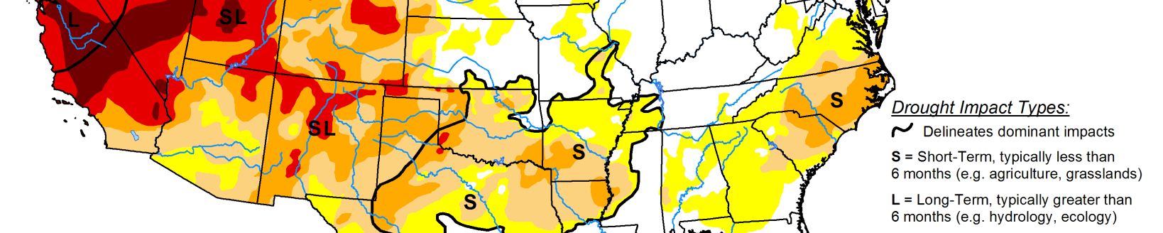
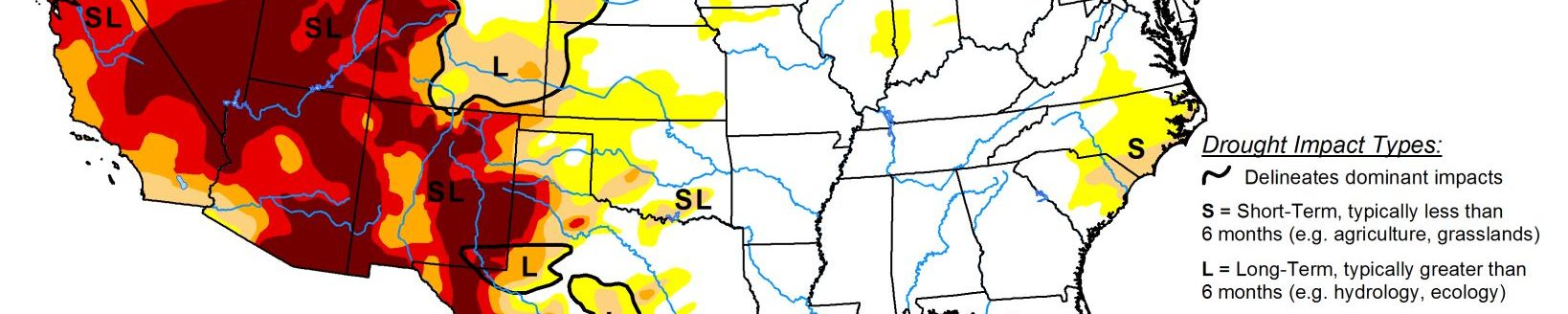
Drought intensifies across High Plains, western and southern US
This U.S. Drought Monitor week saw intensification of drought across parts of the western U.S. including California, Nevada, and Colorado where precipitation has been below normal since the beginning of the Water Year (Oct. 1). In California, statewide snow water content is currently at 36% of the historical average for the date (Dec. 7) and Water-Year-to-Date precipitation (statewide) is ranging from the bottom 10% to the bottom 33% with some areas in the Mojave Desert experiencing the driest on record for the period.
According to NOAA’s National Centers for Environmental Information, the 6-month period from June to November 2020 was the hottest and driest on record for both Arizona and California. Current snowpack conditions across the West are generally reflective of a La Niña-like precipitation pattern with the mountain ranges in the Pacific Northwest and some areas of the northern Rockies observing near-normal to above-normal snowpack conditions.
Further south in the Four Corners states, basin-wide (6-digit HUC) SWE is below normal in nearly all drainage basins in the region. Elsewhere on this week’s map, areas of Texas including the Panhandle and central Texas saw some minor deterioration in conditions where both long and short-term precipitation deficits exist.
High Plains
On this week’s map, areas of the region—including southwestern North Dakota and central Nebraska—saw modest expansion in areas of Severe Drought (D2) as well as expansion in areas of Moderate Drought (D1) in southwestern North Dakota in response to a combination of factors—short-term precipitation deficits, lack of seasonal snow cover, depleted soil moisture, and unseasonably warm temperatures (12 to 20 degrees F above normal)—during the past week. In the eastern Plains of Colorado, areas of Extreme Drought (D3) and Exceptional Drought (D4) expanded where long-term precipitation deficits continued to mount.
South
On this week’s map, areas of drought intensified and expanded in the Panhandle and central Texas where both long and short-term precipitation shortfalls exist. In these areas, 6-month precipitation deficits ranged from 4 to 8+ inches. Conversely, above-normal precipitation during the last 30-day period led to improvements on the map in areas of Moderate Drought (D1) and Abnormally Dry (D0) along the Coastal Plain region of Texas. According to the USDA for the week of November 29, 61% of topsoil moisture in Texas was rated short to very short and 34% of the winter wheat crop was reported to be in poor to very poor condition. Elsewhere in the region, short-term dryness during the past 30-day period led to expansion of areas of Abnormally Dry (D0) across portions of Louisiana, Arkansas, Mississippi, and Tennessee. Average temperatures for the week were well below normal (4 to 10+ degrees F) across the entire region.
Midwest
On this week’s map, some minor expansion of areas of Moderate Drought (D1) occurred in central Illinois in response to short-term precipitation deficits (60 day to 6 months), low streamflows, and areas of below-normal soil moisture. Overall, the region was generally dry during the past week with below-normal average temperatures in the southern half of the region and above-normal temperatures in the northern portion with the greatest positive anomalies (6 to 12+ degrees F) observed in western Minnesota. According to the NOAA NOHRSC, 13% of the Northern Great Lakes region was covered by snow with an average snow depth of 0.2 inches and a maximum depth of 5.4 inches.
West
During the past week, high pressure continued to dominate across much of the region with essentially no precipitation observed except for some light precipitation along coastal Oregon and Washington.
Across the mountain ranges of the Four Corners states, snowpack conditions are well below normal across with the Little Colorado, Salt, Upper Gila, Rio Grande-Mimbres, Rio-Grande Elephant Butte, Upper Canadian, and Upper Pecos basins—all below ~50% of normal. According to the NRCS (Dec 1), statewide reservoir storage was below normal in Colorado, Nevada, New Mexico, and Oregon while above-average levels were observed in Arizona, Idaho, Utah, Washington, and Wyoming (data not available for California and Montana). Looking at the last 6-month period, the Southwest (Arizona, Colorado, New Mexico, Utah) and West (California, Nevada) climate regions both experienced their hottest and driest June-November period on record, according to NOAA NCEI.