Showers and thunderstorms move across the Central Plains and Midwest while dry air mass covers Southern Plains
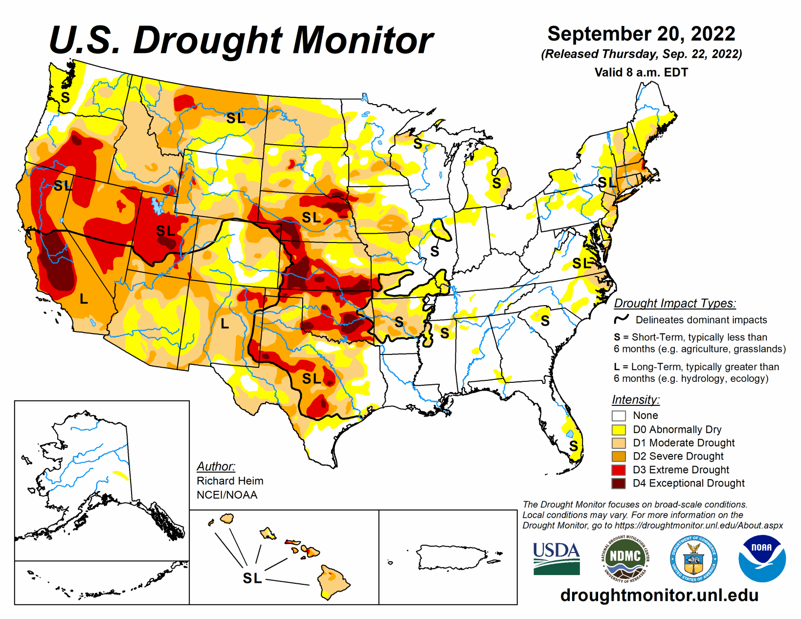
An upper-level ridge dominated the central contiguous U.S. during this U.S. Drought Monitor week (Sept. 14 to 20). It was bracketed by an upper-level trough that moved out of the Northeast early in the week, and a Pacific upper-level trough that moved into the West as the week progressed. Pacific weather systems moved across the northern states between the troughs. This pattern resulted in above-normal precipitation across much of the West and parts of the Northeast.
Fronts associated with the Pacific systems triggered showers and thunderstorms across parts of the central and northern Plains to Mid and Upper Mississippi Valley. For the rest of the CONUS, a large dry air mass covered much of the southern Plains and East throughout the week.
Temperatures averaged warmer than normal across the Plains to Great Lakes, and cooler than normal across much of the West, Southeast, and northern New England.
South
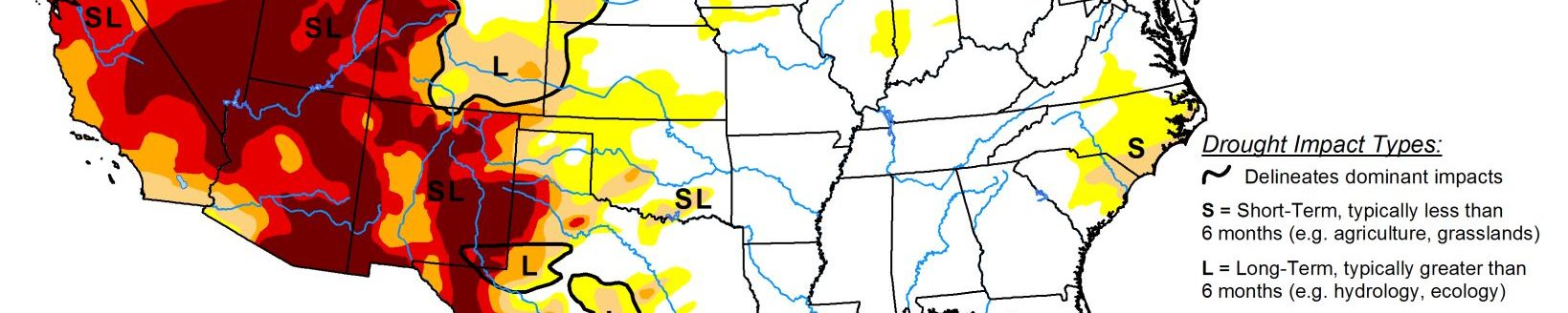
A few areas of the Gulf Coast and western Texas received up to half an inch of rain this week, but the South region was, for the most part, dry with no rain falling. Moderate and severe drought contracted slightly in a couple spots in southern Texas, and abnormal dryness and moderate drought expanded in a couple other areas of the Lone Star State and abnormal dryness expanded in Tennessee. But the biggest changes occurred in Oklahoma and Arkansas. D1-D4 expanded in Oklahoma and D0-D2 expanded in Arkansas. Soils continue to dry and groundwater and stream levels are low.
According to U.S. Department of Agriculture (USDA) statistics, 82% of Oklahoma’s topsoil moisture is short to very short of moisture (dry to very dry). The only drier years in mid-September in data going back to 2010 were 2011 and 2012, which were very bad drought years. All states in the region except Louisiana and Mississippi had half or more of the topsoil moisture short or very short of moisture. Almost 70% of the pasture and rangeland in Oklahoma was in poor to very poor condition. Ponds in Oklahoma are drying up and 63% of the cotton crop is in poor to very poor condition.
Midwest
Two inches or more of precipitation fell this week in a streak across southern Iowa to central Illinois, and over northern parts of the Midwest region. Other areas had up to half an inch of rain, while southern parts (southern Missouri to Kentucky) and parts of the Great Lakes had little to no rain. D2-D3 contracted in southeast Iowa to adjacent Illinois and northeast Missouri where the heaviest rains fell. D0-D1 contracted in Illinois and D0 shrank in parts of Indiana and Minnesota. But the bigger change was expansion of drought in several Midwestern states. D0-D3 grew in Missouri, D0-D2 expanded in Minnesota and Wisconsin, and D0-D1 expanded in parts of Michigan and Illinois.
High Plains
Parts of the High Plains region had rain while other parts were dry. Up to two inches fell locally in parts of several states. Especially dry areas occurred in parts of the Dakotas, Montana, Kansas, and Colorado. The lack of rain was accompanied by unusually hot temperatures regionwide, which increased evapotranspiration and accelerated the drying of soils. The drying soils and dry ponds and waterholes led to extensive expansion of D0-D2 in North Dakota and Montana, and D0-D4 in South Dakota and Kansas. Groundwater levels are low with wells in Wichita, Kansas, going dry.
According to media reports, a water emergency developed in Caney, a town in southeast Kansas, when water stopped flowing over the Little Caney River’s dam; there are 6 weeks of water supply left. D1 and D2 expanded in parts of Colorado, and D3 expanded in southeast Wyoming while other parts of the state saw contraction of D0 and D1. Nebraska also had some contraction of D2, but expansion of D1-D3 in other parts of the state. According to USDA statistics, all states in the region had half or more of the topsoil moisture short or very short of moisture. In Nebraska and Kansas, three-fourths of the pasture and rangeland was in poor to very poor condition, while the value was 50% for Colorado, 55% for South Dakota, and 58% for Montana.
West
Pacific weather systems dropped locally 2 or more inches of rain across parts of central and northern California, and over local areas of the Great Basin and southern New Mexico. Half an inch or more of precipitation occurred over large parts of the interior West. Other parts, especially much of Washington, Oregon, northern Idaho to northwestern Montana, and southern California to parts of New Mexico, were dry this week. Groundwater continues low and many reservoirs were still very low to near record low. The water levels in most reservoirs in New Mexico are well below average.
The August 2022 total combined end-of-month storage of 12 large reservoirs in the state ranked among the three smallest August totals since 1990. The precipitation that fell this week did little to make up deficits that have built up over the last 5 years, so little improvement was made on this week’s map over the areas that received precipitation. One exception was southern New Mexico and adjacent Arizona, where D1-D3 contracted in the wetter areas this week that have also benefited from a wet monsoon season.