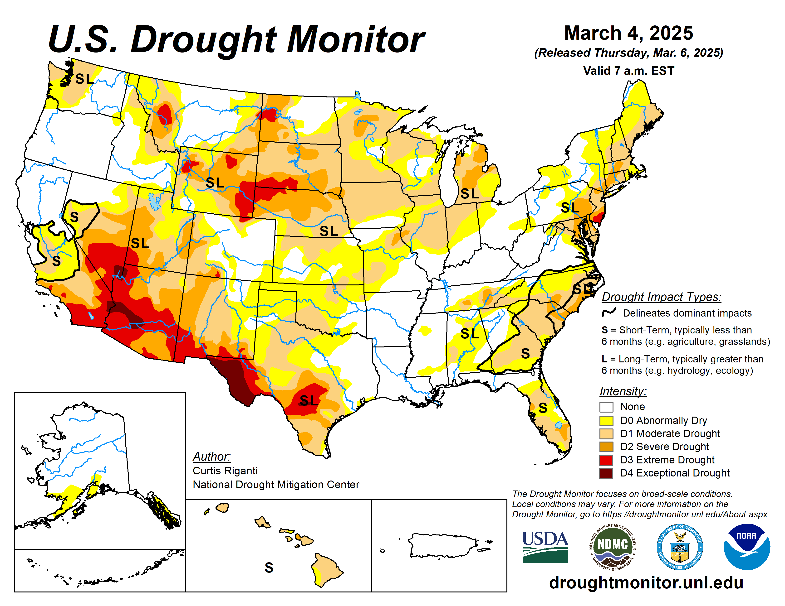
A few swaths of precipitation occurred across the country, including the Sierra Nevada, northwest California and western portions of Washington and Oregon, during the past week.
Some high elevation areas of the West received precipitation as well, mostly outside of the desert Southwest. Some areas of the Upper Midwest and Northeast received a quarter of an inch of precipitation to locally over an inch. At the end of the current drought monitoring period (Tuesday morning), a powerful storm system was emerging into the Great Plains, delivering thunderstorms, high winds and wind-driven snow to parts of the Great Plains and Midwest.
While some of this precipitation fell overnight Monday into early Tuesday morning, most of this precipitation will not be accounted for until the next U.S. Drought Monitor update. Temperatures generally ranged from 5 to 15 degrees Fahreheit warmer than normal in the Great Plains, with locally warmer readings in the Dakotas and eastern Montana. With some exceptions, temperatures were mostly within 5 degrees of normal across the rest of the contiguous United States.
Mostly dry weather in the lower Midwest and southern Great Plains led to expansion of ongoing abnormal dryness and drought. Improvements to snowpack in parts of Idaho, western Wyoming and southwest Montana led to some improvements to conditions there.
The U.S. Drought Monitor is jointly produced by the National Drought Mitigation Center at the University of Nebraska-Lincoln, the U.S. Department of Agriculture and the National Oceanic Atmospheric Administration. (Map courtesy of NDMC.)
South
Temperatures across the South were mostly warmer than normal, with much of Texas and Oklahoma finishing the week 6 to 10 degrees above normal.
A line of thunderstorms associated with this week’s powerful low-pressure systems produced widespread rain of 0.5-1 inches in central and western Oklahoma and central north Texas, though areas east of there did not receive precipitation from this storm system until after the Tuesday morning data cutoff.
Scattered drought degradations occurred in the western halves of Texas and Oklahoma, due to increasing precipitation deficits and locally decreasing streamflow and soil moisture.
Groundwater and reservoir levels continued to drop in central Texas in the San Antonio area amid very large precipitation deficits, leading to the development of a small area of exceptional drought. Similar conditions in southwest Texas led to the expansion of exceptional drought along the Rio Grande to the El Paso area.
Midwest
Temperatures in the eastern half of the Midwest region were generally near normal to 5 degrees above normal. In the western half of the region, temperatures from 5-15 degrees above normal were common.
Growing precipitation deficits, especially in the short-term, combined with low streamflow and soil moisture, led to the expansion and development of moderate and severe drought in northern Missouri. Elsewhere in the Midwest, no changes occurred to the USDM, though low seasonal snowfall totals in parts of Minnesota are of growing concern as the transition to spring occurs.
High Plains
Temperatures across most of the High Plains were above normal, with most locations east of the Rocky Mountains finishing the week between 9 and 15 degrees warmer than normal. Some precipitation fell in mountainous areas of Colorado and Wyoming, and snow occurred Monday night into Tuesday morning in parts of the northeast Colorado plains into western and central Nebraska.
Most of the High Plains region east of the Rocky Mountains did not see any changes to ongoing drought or abnormal dryness, except for southern Kansas, where abnormal dryness expanded in response to unusually dry weather in the last few months.
In western Colorado, moderate and severe drought expanded in coverage due to very low snowpack and growing precipitation deficits. Recent precipitation in west-central Wyoming led to localized improvements to drought conditions there.
West
Temperatures were warmer than normal in most of the West, with the warmest conditions of 9 to 15 degrees above normal occurring in the central and eastern plains of Montana. Recent improvements to snowpack in southwest Montana led to localized improvements to drought conditions.
Meanwhile, to the south across New Mexico, continued dry weather led to widespread drought degradation as short- and long-term precipitation deficits grew amid soil moisture, streamflow and groundwater deficits.
Looking ahead
Through the evening of March 10, the National Weather Service Weather Prediction Center is forecasting parts of coastal and high elevation California, along with portions of the high elevation West to receive 0.75 or more inches of precipitation, though this is mostly expected to miss New Mexico, Montana, northern Idaho, Washington and Oregon.
A few other corridors of at least a half inch of precipitation are forecast across northern Nebraska, from southeast Oklahoma to South Carolina and the Florida Panhandle, and in New England. Some areas of the Southeast may receive at least 1 inch of rainfall.
Looking ahead to March 11 to 15, the National Weather Service Climate Prediction Center forecast favors above-normal precipitation in the northern Contiguous U.S. and strongly favors above-normal precipitation in the western, and especially southwestern U.S.
Below-normal precipitation is favored in most of Texas, especially in far southern reaches of the state. Colder-than-normal temperatures are favored across the West, while warmer-than-normal weather is favored across most of the central and eastern contiguous U.S.
Curtis Riganti is with the National Drought Mitigation Center.


