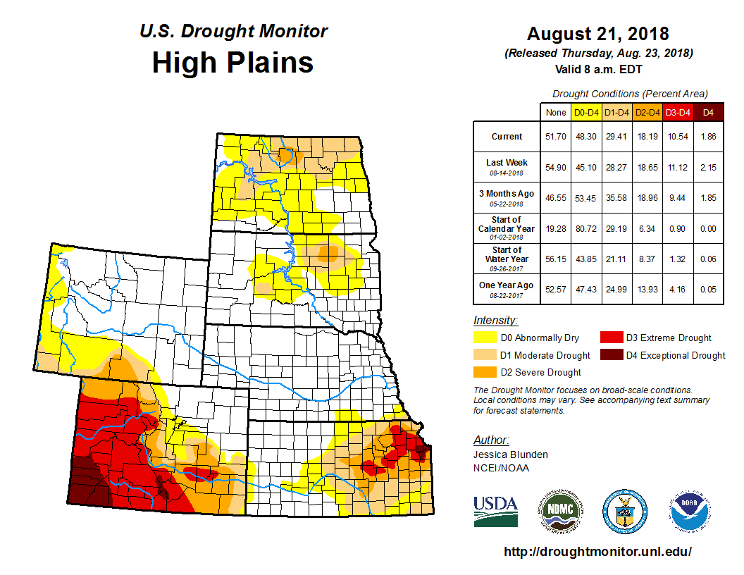
Areas of low pressure brought heavy to excessive rainfall to many parts of the U.S. during this past drought week (Aug. 14 to 21), according to the Aug. 21 U.S. Drought Monitor released Aug. 23. Some storms brought more rainfall to already inundated areas such as the Northeast, but some activity occurred over drought regions badly in need of moisture, including the Central and Southern Plains, the Midwest, and the South. Other areas, especially along the northern tier of the country, continued to dry out amid a combined lack of rainfall and anomalously high temperatures. Some areas of northern Michigan and Wisconsin averaged daily maximum temperatures 6 to 8 degrees F above their typical average for this time of year.
The northern tier of the High Plains saw conditions continue to dry out over this past week, exacerbated by high temperatures in some areas. Mercer County, North Dakota, for example, saw temperatures reach 104 degrees F on two days and 10 consecutive days of upper 90s. Crops have been impacted as soil moisture is depleted, with very dry topsoil and subsoil. There are reports of corn burning and severely stressed soybeans, among other impacts. As such, areas of abnormal dryness (D0), moderate drought (D1), and severe drought (D2) were expanded in various parts of the state. Eastern Montana saw an expansion of D0, including along the North Dakota border. Nebraska and Kansas, on the other hand, were the recipients of heavy rainfall events, which led to improvements across their drought regions. Although rainfall was 2 to 6 inches in places, long-term dryness persists across parts of the regions and thus was not adequate to erase all drought. However, two category improvements (D3 to D1) were made in southeastern Kansas, for example, as the rain did vastly improve conditions there. In Colorado, D1 was reduced in El Paso and Douglas counties, which received 1 to 4 inches of rain over the past few weeks, improving conditions there.
Some regions of the Midwest received excess rainfall this week from heavy downpours, while other areas mostly missed out on the events, leading to some improved drought areas and some degraded drought areas. Along the U.S./Canadian border of Minnesota, several areas reported precipitation accumulations among their lowest 20 percent (since April 1), leading to expanded abnormal dryness (D0) and moderate drought (D1). Likewise, Michigan’s northern lower peninsula has continued to experience below-average rainfall, leading to reported dying foliage (ferns). Here, an area of moderate drought (D1) expanded and severe drought (D2) was introduced. Rainfall was deficient in central to southern Iowa, where D0, D1, D2, and a bit of D3 (extreme drought) expanded. Parts of northern Illinois also remained dry over the past month or so, leading an expanded area of abnormal dryness (D0), while northern Indiana and northern Ohio saw some improvement. Missouri saw more than 5 inches of rain fall in places. Conditions in this state improved considerably in many areas, although rainfall, even more than an inch or two, wasn’t enough to overcome the lingering longer-term dryness in other areas.