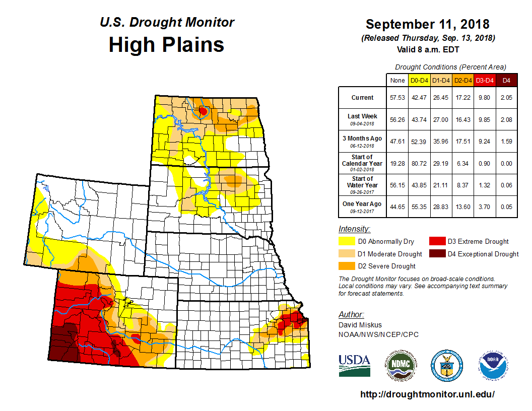
According to the Sept. 11 U.S. Drought Monitor released Sept. 13, a stalled cold front draped across the southern Plains, middle Mississippi and Ohio Valleys, and mid-Atlantic, plus ample Gulf moisture from Tropical Storm Gordon, was the focal point for moderate to heavy showers and thunderstorms. Widespread amounts of 2 to 4 inches, with locally 6 to 12 inches, were common in the southern and central Great Plains, along the Gulf Coast (Gordon), in the lower and middle Mississippi, Tennessee, and Ohio Valleys, western Great Lakes region, and the mid-Atlantic. Similar to last week, additional improvements were made in the Midwest, but this week, major modifications (improvements) were also done in the southern Plains (especially Texas) and lower Mississippi Valley. Elsewhere, little or no precipitation fell across the western third of the nation, although some light showers finally dampened western Washington. In addition, the northern Plains, parts of the Southeast (Georgia and Carolinas), and extreme northern New England saw little or no rain. Temperatures averaged below-normal across the middle third of the Nation and in New England, and above-normal in most of the West, Southeast, and mid-Atlantic.
Generally little or no precipitation fell across the western High Plains while light rains (0.5 to 1 inch) fell on parts of North Dakota, southeastern South Dakota, eastern Nebraska, most of Kansas, and central Colorado. Scattered locations in extreme southeastern South Dakota, northeastern Nebraska, and eastern Kansas received more (1.5 to 3 inches, locally to 7 inches in southeastern Kansas), but most of this rain fell on non-drought areas. An exception to this was north-central and southeastern Kansas where a 1-cat improvement was made, but unfortunately missed most of the core D2-D4 area in northeastern Kansas (again). Kansas pastures and ranges have also improved, with a NASS/USDA Aug. 12 value of 35 percent poor or very poor versus a Sep. 9 value of 20 percent. Subnormal weekly temperatures (anomalies of -2 to -6 degF) in the central Plains also eased evaporative demands. In contrast, drier and warmer weather in the Dakotas have steadily lowered moisture and growing conditions. Under half of normal 30- and 60-day precipitation has fallen on parts of North and South Dakota, and field reports are indicating declining farming, ranching (no forages to graze), and hydrologic (shallow wells and small ponds drying up) conditions. The NASS/USDA poor and very poor pasture conditions for the Dakotas have slowly climbed from 7 and 10 percent, respectively, on July 29, to both at 25 percent on Sep. 9. Accordingly, D0-D2 was expanded into the driest areas, and a D3 was added in McHenry County, North Dakota, where the field reports and drought tools lined up.


