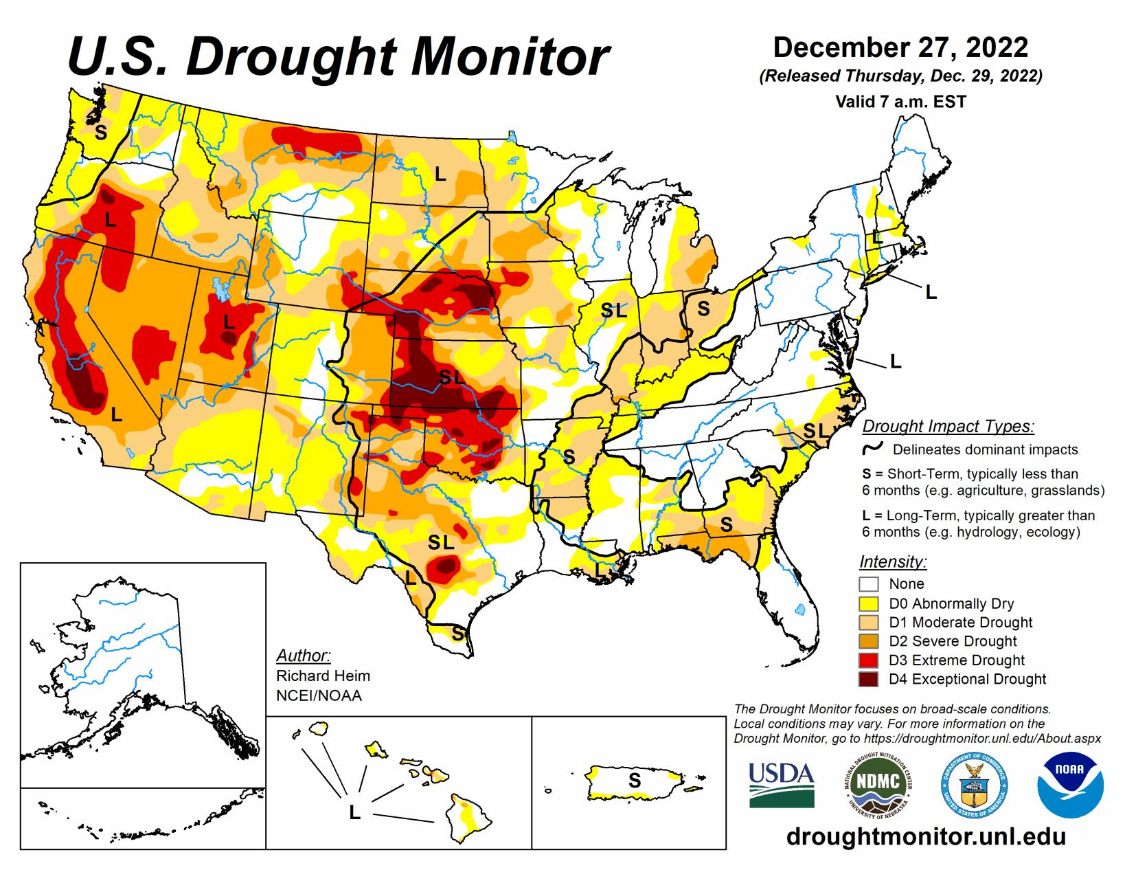
A powerful low-pressure trough developed in the upper levels of the atmosphere over the eastern contiguous U.S. during this U.S. Drought Monitor week (Dec. 21-27). At the surface, the trough was associated with a strong cold front that poured frigid arctic air into the U.S. east of the Rockies. Daytime maximum temperatures in the northern Plains were well below zero degrees Fahrenheit, with minimum temperatures colder than 20 below zero, at the peak of the cold wave.
Bismarck, North Dakota, registered minus 10 for a high and minus 20 for a low on Dec. 21 and 22; the high was below zero for four consecutive days and below freezing for at least two consecutive weeks. Williston, North Dakota, recorded minus 17 for a high and minus 29 for a low on Dec. 20. The freezing arctic air spread to the Gulf of Mexico and East coasts and even breached the Rocky Mountain chain to reach the Pacific Northwest. The high temperature at Tupelo, Mississippi, was only 18 degrees with a low of 4 on Dec. 23.
Rain, freezing rain, and snow accompanied the arctic front as it swept east and south. An inch or more of precipitation fell across parts of the Gulf Coast and from the Appalachians to East Coast when the front tapped Gulf and Atlantic moisture. Some parts of the Mid-Atlantic and Northeast states received over 2 inches of precipitation, while an inch or more occurred over the lee sides of the Great Lakes, largely in the form of heavy lake effect snow. Buffalo, New York, officially measured 50.3 inches of snow from Dec. 23-26, but much more snow fell in other favored leeside areas. Locally up to half an inch of precipitation occurred from the northern Plains to Upper Mississippi Valley. But the northwesterly flow was otherwise dry, so large parts of the Great Plains, Mississippi Valley, and Ohio Valley to Gulf Coast received less than half an inch of precipitation to no precipitation. The arctic blast froze soils across much of the Great Plains to Upper Mississippi Valley. Any precipitation that fell was not able to penetrate the frozen ground to increase soil moisture, so much of this region had no change in USDM status.
In reaction to the eastern trough, an upper-level ridge developed over the western CONUS. This kept weekly temperatures near to warmer than normal from California to the Four Corners states, but it also kept much of the West dry. The exception was northern California to the Pacific Northwest and parts of the central and northern Rockies, where Pacific fronts brought areas of rain and snow. Two inches or more of precipitation fell in coastal areas and in the northern Rockies, with up to ten inches in parts of western Washington. Meanwhile Hawaii and Puerto Rico had a mostly drier-than-normal week while drier- and colder-than-normal weather dominated Alaska. The deep freeze and dry weather resulted in status quo conditions for much of the country. Drought or abnormal dryness expanded in parts of the Midwest, Colorado, and Puerto Rico, while contraction occurred in a few areas in the Southeast, East Coast, Wisconsin, Colorado, and Washington.
South
This week was drier than normal across all of the South region. Around half an inch of rain fell over parts of southern Mississippi and southeast Louisiana. Otherwise, weekly precipitation totals were less than a tenth of an inch, with large parts of Texas and Oklahoma receiving no precipitation. Much of the region has been wet during the last 2 months, but dry conditions dominate at longer time scales. The cold and dry conditions this week locked moisture conditions in place, so no change was made to the USDM depiction in the South.
Midwest
Parts of Minnesota and Iowa received up to half an inch of precipitation this week, while an inch to more than 2 inches fell in favored snowbelt areas to the lee of the Great Lakes in Michigan. The rest of the Midwest received less than half an inch, with the driest areas over southwestern portions of the region. The precipitation amounts were above normal in parts of Minnesota, Iowa, Wisconsin and Michigan, while the rest of the region was drier than normal for the week.
Moisture surpluses eliminated the spot of D1 in northern Wisconsin, but the deep freeze locked conditions in place in Iowa and Minnesota where no changes were made. D0 and D1 were expanded in Indiana, Illinois, Ohio, and Lower Michigan, and D0 expanded in eastern Missouri, based on several indicators. These indicators include dry soils, low streamflow, and mounting precipitation deficits, especially as seen in the 1- to 12-month Standardized Precipitation Index.
High Plains
Most of the High Plains region received less than half an inch of precipitation. Pockets of half to 1 inch of precipitation were found over North Dakota and the mountains of Colorado and Wyoming. The precipitation was above normal in parts of all of the High Plains states, but late December is in the dry season for much of the region and normals are low. With the entire region experiencing a deep freeze this week, little change was made to the USDM depiction. The exception was Colorado, where D0 expanded in south central counties due to low snowpack and 1- to 4-month precipitation deficits, and D0-D1 contracted in north central counties based on precipitation surpluses at the 1-week to 3-month time scales.
West
Pacific frontal systems brought rain and snow to coastal areas of the West, from northern California to Washington, and to parts of the Rockies. Two to 5 inches of precipitation fell along the coastal and Cascade ranges, with up to 10 inches locally in Washington. Amounts ranged up to 2 inches or more in the northern Rockies. Pockets of up to 1 inch of precipitation were found over the central Rockies, but for the states further south, southern California, and the intermountain basin, little to no precipitation occurred.
Related Articles