According to the U.S. Drought Monitor for Oct. 9 released Oct. 11, the same strong system that soaked parts of Texas and Oklahoma dropped excessive rains on areas of entrenched D2-D4 drought in northwest Missouri and southern Iowa, and extending into northeastern Kansas. Almost the entire area received at least 4 inches of rain, with 7 to 12 inches recorded in a broad band across east-central Kansas and northwestern Missouri. The resulting improvement was dramatic, with most areas seeing a 2-category improvement in Drought Monitor classification.
Lesser amounts of rain fell on the existing dry areas farther south in Missouri and across both northern and southeastern Michigan. Amounts were substantial enough to eliminate almost all dryness and drought in Michigan, and create notable improvement to parts of central and southern Missouri.
Precipitation has been generally above normal in northern Minnesota for a few months (extending into the Dakotas), and 1.5 to 3.0 inches fell this past week on much of the region. As a result, D0 and D1 areas close to the Canadian border retracted somewhat.
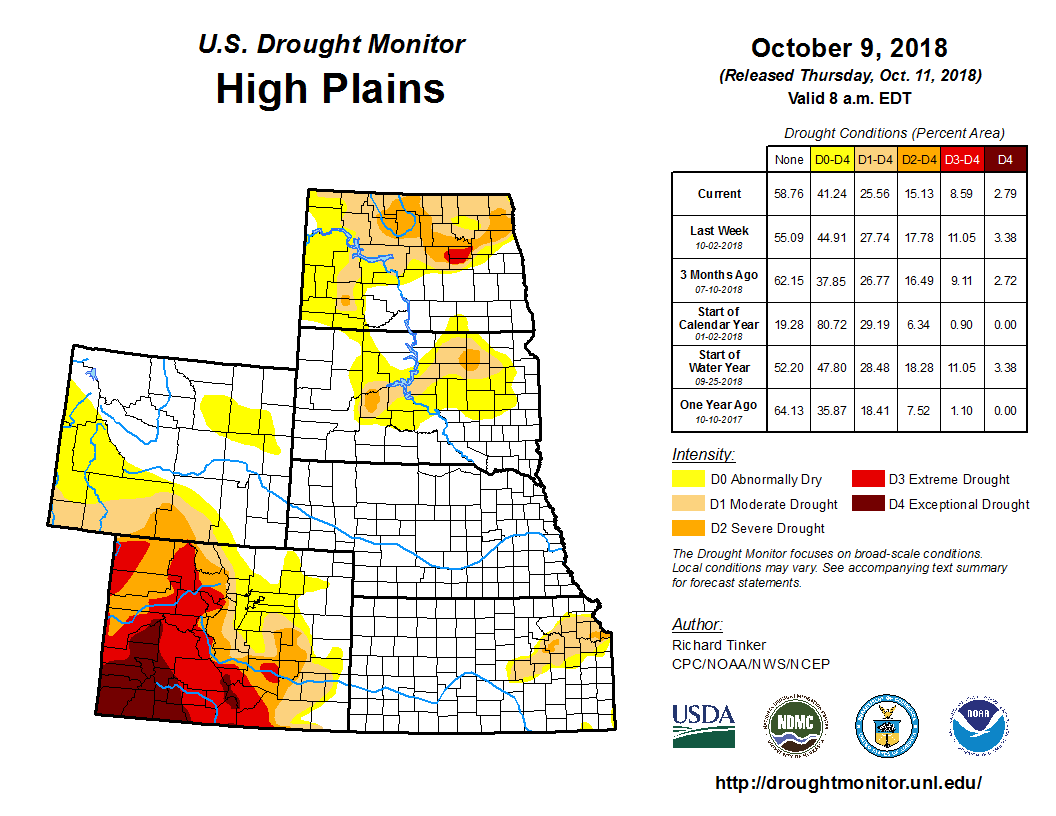
In the High Plains, precipitation has been generally above normal in the Dakotas for a few months (extending into Minnesota), and 1.5 to 3.0 inches fell this past week on central and eastern North Dakota, with light to moderate totals reported elsewhere. Much of these states are covered by dryness and drought of varying intensities. Precipitation was insufficient to bring any changes to South Dakota, but most of the dry areas in North Dakota, ranging from D0 to a small area of D3, all retracted a bit.
Farther south, existing areas of dryness and drought in east-central and northeastern Kansas were inundated by the heavy to excessive rainfall from the same system that impacted Missouri. And, also like Missouri, the areas of dryness and drought improved dramatically, with 2-category Drought Monitor improvements common.
Looking westward, areas of moderate precipitation were observed in Colorado and Wyoming, most notably in western Colorado (1.5 to locally 3.5 inches). A more broken pattern of moderate to heavy precipitation existed elsewhere; light precipitation was most prevalent in northern and eastern Wyoming.
The precipitation was beneficial in the Upper Colorado River Basin and in southeastern Colorado, where a good hydrologic response to the precipitation was observed. Dry soils were recharged somewhat, and streamflows notably increase. The large, intractable areas of extreme to exceptional drought remain entrenched, but a few areas showed mild improvement, and this is reflected in parts of the D3 to D4 areas in the Drought Monitor. Adjacent D0 to D2 areas, where dryness is less protracted and intense, showed a bit more recovery.


