Moderate and severe drought continue in south central and southwest Kansas
Warmer than normal temperatures were common this week over the eastern half of the continental U.S., while temperatures were primarily near normal over the western half, with a few exceptions. Moderate to heavy precipitation was common this week along and east of the Interstate 35 corridor, excepting parts of the Northeast and the Florida Peninsula.
In the West, moderate to heavy precipitation also fell in some of the higher elevation areas. The only exceptional drought occurring in the United States, on Maui, was removed this week after a major precipitation event in Hawaii, where other improvements were also made. Heavy rainfall in northern and eastern Puerto Rico also ended the moderate drought there. In the central and eastern continental U.S., drought conditions generally improved in areas that received heavier precipitation, while some degradation occurred in locations in Texas and Oklahoma that remained drier.
Across the southern portion of the region (roughly the southeastern halves of Iowa and Wisconsin to the southeast), widespread precipitation of at least a half inch fell this week. The heaviest amounts fell from central and southern Missouri through southern portions of Illinois and Indiana, where precipitation amounts ranging from 2 to locally as high as 5 inches were common. Warmer than normal temperatures covered most of the region, particularly in Ohio and Kentucky and southern Indiana, where some locations were at least 15 degrees warmer than normal for the week. In contrast, northern Minnesota was 5 to 10 degrees below normal. Abnormal dryness ceased in western Indiana, where over 2 inches of rain fell. Elsewhere across the region, freedom from drought and abnormally dry conditions persisted.
Most of the South had warmer than normal temperatures this week, though widespread rainfall led to reduction in drought conditions in parts of the region. Temperatures ranged from 10 to 15 degrees warmer than normal in Mississippi and Tennessee to generally 5 to 10 degrees above normal in Oklahoma and Texas. Excluding south Texas, moderate to heavy rain fell across the portion of the region to the east of the Interstate 35 corridor. The highest rain amounts, with some locations exceeding 3 inches, fell upon north-central Texas, southeast Oklahoma, Arkansas, far northeast Louisiana, and northern Mississippi. The heavy rain in east Texas and adjacent portions of Louisiana, Arkansas, and southeast Oklahoma led to improvement in drought and abnormally dry conditions in these areas, where short-term precipitation shortages were lessened, and streamflow improved. In areas west of the more widespread precipitation in Texas and Oklahoma, some of the drought and abnormally dry areas were expanded where short-term precipitation deficits grew.
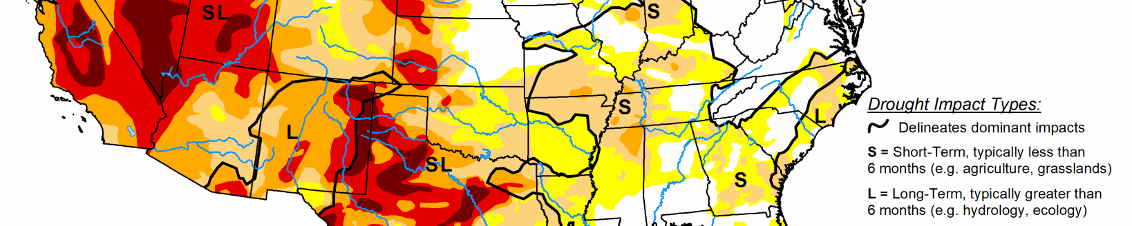
Across the High Plains region, primarily dry and near normal or cooler than normal conditions occurred, with the exceptions of south-central and eastern Kansas, where warmer than normal temperatures occurred and over a half inch of precipitation fell. Temperatures mostly ranged from 5 to 10 degrees cooler than normal in South Dakota and North Dakota this week. Moderate and severe drought continued in south-central and southwest Kansas, respectively, and no changes were made to the drought or dryness depiction in the region.
Temperatures varied across the West region over the past week. Eastern Utah and north-central Montana had temperatures 5 to 15 degrees cooler than normal, while western Utah was 5 to 10 degrees warmer than normal. Warmer temperatures continued in the eastern and southeastern plains of New Mexico, and abnormally dry conditions were expanded where high evaporative demand combined with lower recent precipitation amounts. Heavy mountain snow occurred in the Cascades, where abnormal dryness and moderate drought slightly improved as short-term precipitation deficits slightly lessened and snowpack grew. High elevation areas of Colorado, Wyoming, Idaho, Montana, northern Utah, and northern California received precipitation this week, while lower elevation locations generally stayed dry. Moderate drought and abnormally dry conditions shifted in Idaho in response to changing snowpack and precipitation deficits over the past week.