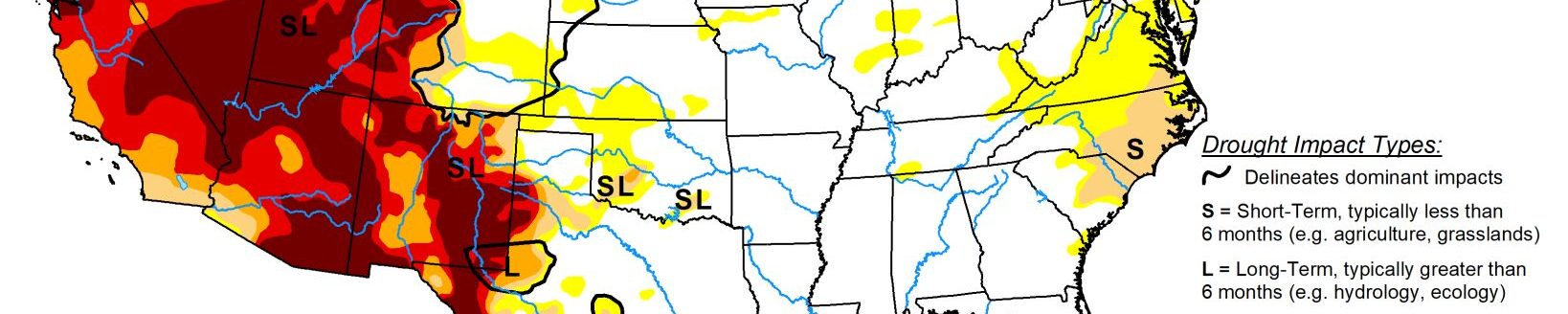
Severe and extreme drought remains in many parts of South and West; widespread precipitation received in other areas
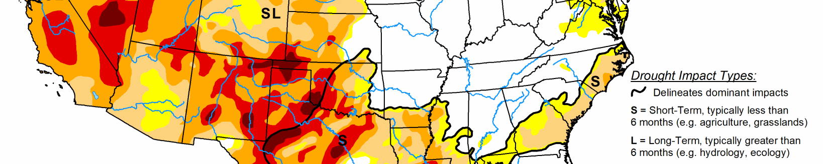
Precipitation fell across much of the northern tier states and the eastern half of the contiguous United States this week. Much of the eastern U.S. has experienced increased dryness over the past 30 to 60 days and above normal temperatures. The heaviest rains missed many of the D0 and adjacent areas, warranting D0 expansion for several locations in the eastern CONUS.
Areas just east of the Rockies missed out on some of the heavier precipitation this week, which fell over central Kansas, central Oklahoma, and northern Texas. This allowed for some improvement, mainly in areas that with D0 and D1 designations at the start of the week. However, severe (D2) and extreme (D3) drought designations remained for many locations in the Texas and Oklahoma Panhandles, eastern New Mexico and Colorado, and western Kansas. Mixed improvements and degradation in the northern Rockies and High Plains.
High Plains
Similar to the Southern and Central Plains, many areas in the High Plains Region have fallen victim to above-normal temperatures, high winds, and a lack of precipitation in recent weeks. Some reduction in drought coverage in areas receiving the heaviest precipitation throughout the region, most notably central Kansas where many areas received 2-6 inches of rainfall. However, elsewhere 30 and 60 day deficits continue to increase, corresponding with D2-D4 equivalent SPIs and 25-50 percent of normal precipitation over the past 30 days across most areas depicted in drought. Soil moisture also continues to suffer across western North Dakota, much of Wyoming, and all of Colorado (CPC showing soil moisture below the 5th percentile for much of Colorado). There have been reports of low reservoir levels in North Dakota. Colorado has reported several episodes of 100-degree days in the southeast portion of the state in recent weeks, as well as cattle being sold and failing winter wheat crops. As such, severe drought (D3) is status quo this week for southern and southeastern Colorado.
South
South-central Oklahoma and northern Texas saw very heavy precipitation this week (4-8 inches). However, accumulations were lacking a bit in areas with D2 and D3 designations. Above-normal temperatures, high wind events, and below-normal precipitation leading up to this week has led to high evapotranspiration rates and hardened soils, increasing runoff. So more rainfall over extended periods is needed for improvement in some of the driest areas in the Central and Southern Plains. Elsewhere in the Southern Region, 30-60 day deficits continue to be the headliner. Although much of the region saw precipitation, many D0 and adjacent areas saw near to below normal rainfall, warranting some D0 expansion in the Tennessee Valley and eastern Texas.
Midwest
The Midwest saw widespread precipitation this week, with the heaviest rain falling in eastern Iowa and across central Wisconsin. Some minor D0 removal in western Iowa, corresponding to areas receiving 1.5-3 inches of rainfall. Some trimming of D0 and D1 in central Minnesota was also warranted, with the area receiving more than 1.5 inches of rainfall. However, D0 was expanded in eastern Minnesota into Pine and southern Carlton Counties, which received little to no rainfall this week. SPIs continue to remain negative (below -1.6 at 30 and 60 days; i.e. D3 and D4) and USGS 7-day average streamflows have fallen below the 10th percentile for these counties. Across the Corn Belt, the heaviest rainfall avoided many D0 and adjacent areas. For locations that did see precipitation, it was near to below normal for the 7-day period. As such, 30-60 day deficits continue to mount, warranting some D0 expansion into some of the drier locations this week. USGS streamflows are also continuing to fall below normal (10th-20th percentile), especially across Indiana.
West
Much of the West remains status quo this week. Montana saw the most change, as 7-day rainfall accumulations over 1 inch were able to dig into some of the short-term departures, mainly in D0 areas. However, extreme eastern Montana missed out on rainfall this week. YTD SPIs are less than -2 in Richland County and USGS 7-day average streamflows are below normal (10th-24th percentile) near and just over the North Dakota/Montana state line, which warranted some D1 introduction there.