High Plains and northern Rockies receive beneficial rainfall
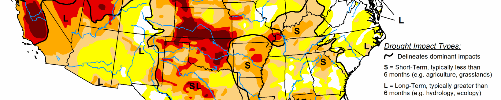
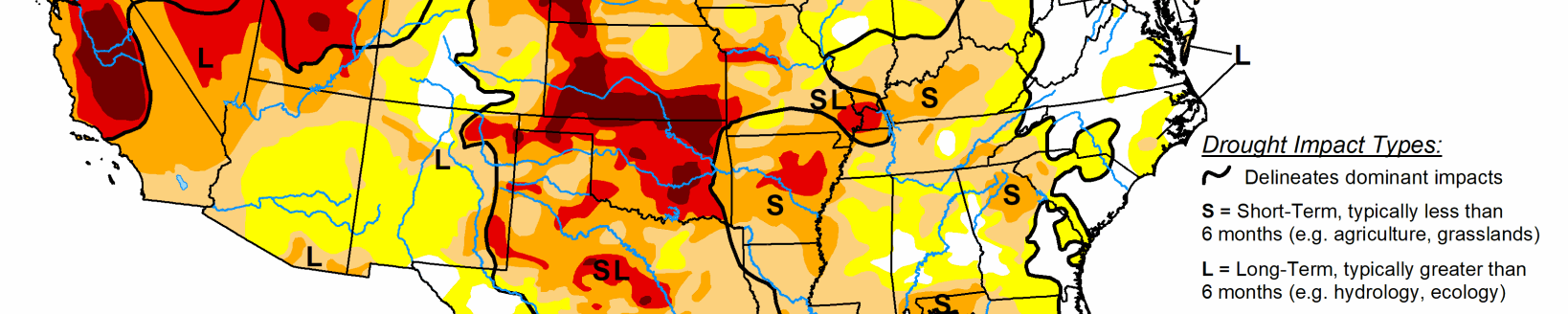
Precipitation was hit-or-miss this week for many locations east of the Great Plains. Much of the Midwest, South, and Southeast saw combinations of D0 additions and removals based on 7-day rainfall accumulations. Most areas with D0 removal observed at least 2 to 3 inches of rainfall.
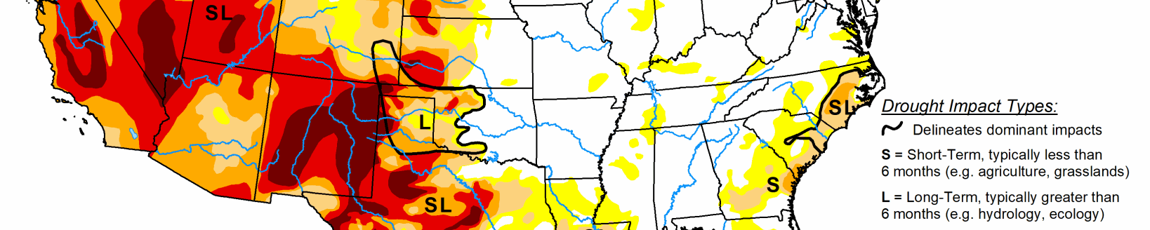
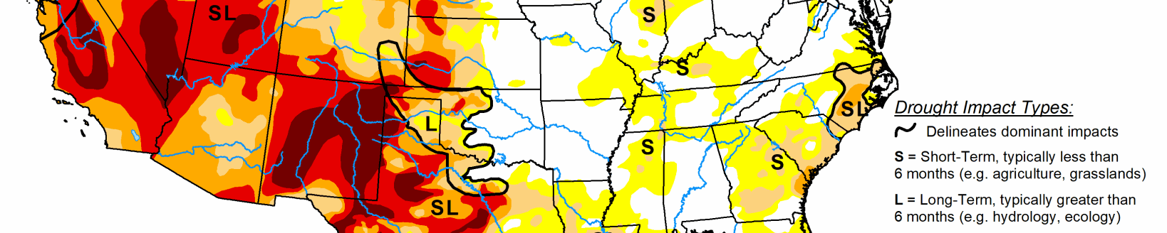
The High Plains and northern Rockies received some beneficial rainfall. Many locations in Idaho saw 1-category improvements (D1 to D0 and D0 removal), but much of the northern High Plains Region did not receive enough rainfall for much improvement. Some degradation from D3 to D4 occurred in southeastern Colorado and southwestern Kansas in areas where little or no precipitation fell and temperatures averaged above normal for the week. The wildfire risk remains high for many locations that remain in drought, particularly in the West.
South
In the Southern Region, the story remains the short-term (30-60 day) dryness. Western Tennessee has missed out in recent weeks on the heaviest precipitation, warranting some D0 expansion (2-3 inch deficits going back 90 days). Northwestern Arkansas and northeastern Oklahoma saw D0 and D1 expansion, as little to no rain fell and most of these areas have received only 10-25 percent of normal precipitation in the last 30 days. 7 inch rainfall deficits in the last 60 days have been observed near Tulsa and Creek Counties in Oklahoma, warranting the addition of a small area of D2. USGS 7-day stream flows are also below normal (10th-24th percentile) for areas around Tulsa County, OK. In western areas of Texas and Oklahoma, heat, low humidity, and lack of rainfall continue to exacerbate existing drought conditions, leading to some D1, D2 and D3 expansion. Widespread D2-D4 SPIs over several time periods for many of these locations.
Midwest
The Midwest saw widespread precipitation where some locations received 3-6 inches of rain. D0 removal from much of the lower Ohio River Valley. The Corn Belt saw both expansion and reduction of D0, depending on where 7-day totals were below and above normal, respectively, adding to 1.5-3 inch 30-day deficits. The Arrowhead of Minnesota and northern Wisconsin saw D0 and D1 expansion, in favor of 3-5 inch 60-day departures, D3-D4 SPIs over several time periods, and much below normal (below the 10th percentile) USGS average 7-day stream flows.
High Plains
Above normal temperatures, low humidity, high winds, and below normal precipitation in recent weeks has led to continued degradation in southeastern Colorado and southwestern Kansas. Although some isolated convection occurred in southeastern Colorado, in areas that did not see precipitation and that continued to see above normal temperatures this week, D4 was introduced, which expanded into southwestern Kansas. However, some D0 and D2 reduction was warranted in western Kansas, as 7-day rainfall accumulations of more than 1.5 inches eliminated 30-day departures for several locations. Some areas of Nebraska saw expansion of existing D0 coverage, where 30-day dryness continues. There are concerns of potential flash drought in eastern Nebraska, where 30-day SPIs of D2 or greater are being reported. The northern High Plains saw enough rainfall this week (1.5-3 inches) to warrant D1 reduction in northwestern South Dakota and southwestern North Dakota. The remainder of the region was generally status quo.
West
The Western Region is mainly status quo, except for the northern Rockies and Pacific Northwest, where an active storm track. Idaho benefitted the most, with several locations seeing 1-category improvements, particularly western Idaho, which received 0.5-1.5 inches of rainfall. Light showers in eastern Washington and northeastern Oregon led to slight reduction of D0 and D1 coverages. Soil moisture is below the 10th percentile in many areas across the Great Basin and northern California. USGS 7-day average stream flows also continue to be below to much below normal this week for much of the Four Corners Region, the Great Basin, and northern California.