Snow and mixed precipitation bring welcome moisture
A blast of frigid Arctic air invaded the North Central States, producing weekly temperatures averaging 15 to 25 degrees F below normal in Montana, the Dakotas, Wyoming, Minnesota, Iowa, and Nebraska. The chill was accompanied by a slow-moving storm system that produced light snow across most of the Rockies, Plains, and upper Midwest. Although outdoor conditions were harsh, the storm and cold were welcome as it brought a halt to the abnormal warmth and dryness that had expanded and deepened the drought in the region.
In the southern Plains, mixed precipitation (snow, sleet, freezing rain, and rain) glazed portions of New Mexico, western Texas, Oklahoma, and Kansas, while beneficial moderate to heavy rains fell from southwestern Oklahoma northeastward into the eastern Great Lakes region. Heavy rains also were measured in the western Great Lakes region and south Florida. Scattered, light precipitation was measured across most of the Pacific Northwest, Southeast, Midwest, and western portions of the Northeast. Much of the Southwest and Intermountain West was dry, with wild fires still burning across California. In addition, little or no precipitation fell on the southern Plains, parts of the Southeast, and eastern sections of the Northeast. Above normal temperatures enveloped the Southwest, southern Plains, and eastern third of the Nation. At the end of the period, all eyes were on Hurricane Zeta in the Gulf of Mexico as it tracked toward yet another Louisiana landfall.
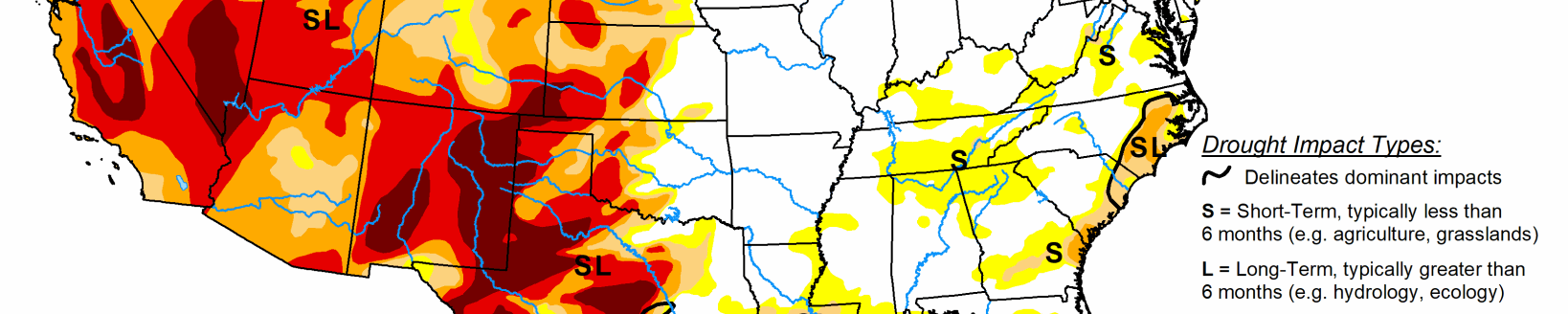
High Plains
A winter storm and frigid air dropped southeastward out of Canada and into the northern and central Rockies early in the period, bringing welcome snows to the mountains, and even at lower elevations of the northern and central Plains. Decent early mountain snows blanketed western and southern Montana, northwestern Wyoming, and parts of southeastern Wyoming, central Colorado, and northern New Mexico. Light to moderate precipitation (mostly snow) also fell on South Dakota and into Minnesota, and parts of western Nebraska. For the most part, the precipitation finally halted the downward deterioration (except for North Dakota) in the region, and actually provided some improvements to western and southern Montana, northwestern and northeastern Wyoming, western South Dakota, southeastern Kansas, and some small D3 to D2 areas in central Colorado where the snows were unusually heavy. In North Dakota, however, precipitation was very light (0-0.25 inches). With indices at 2-3 months and longer (6-months) at D2 or drier, plus field reports of shallow water holes dry, low levels in rivers and larger bodies of water, no regrowth of forages, and poor pastures, an expansion of D1 in the northeast and D2 in central sections was justified.
South
A stalled front and the winter storm in the southern Rockies brought beneficial precipitation to portions of the south-central Plains and lower Missouri Valley. With temperatures dropping as the week progressed, light frozen precipitation (freezing rain, sleet, snow) coated parts of western Texas and Oklahoma and southern Kansas, with heavier rains (1.5-4 inches, locally higher) reported from southwestern Oklahoma northeastward into Missouri. Unfortunately, southern and eastern sections of Texas missed out on the rain, and short-term dryness (2-3 months) increased, with an expansion of D0 and D1 in southern and eastern sections, and D2 in south-central Texas. With the ongoing storm in the southern Rockies on Day7 and more precipitation expected, a wait and see approach was made, thus it was status-quo for western Texas and Oklahoma this week. In contrast, welcome rains fell from extreme northern Texas across central Oklahoma and into northwestern Arkansas, providing a 1-category improvement to most areas, and even some small 2-cat improvements in northwestern Arkansas and southwestern Missouri where the rains were the greatest (3.5-5 inches). Elsewhere, the small D0 in southeastern Louisiana was expanded northeastward as the past 2-3 months have brought 25-50% of normal rainfall, creating 4-8 inch deficits. However, Hurricane Zeta is expected to inundate this area as it makes landfall near here, so the D0 should be a memory next week.
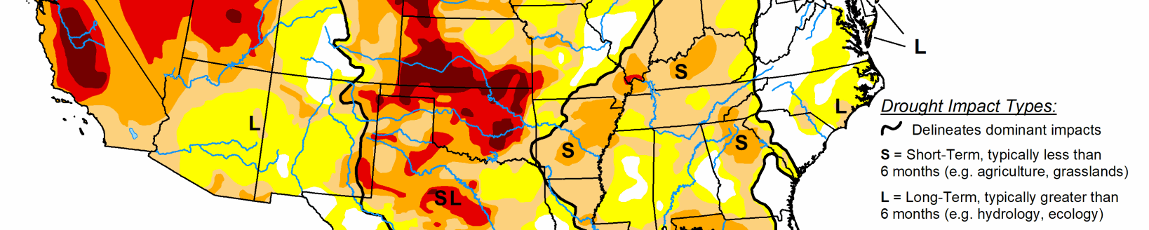
Midwest
In addition to the heavy rains in southern Missouri, the Rockies storm and a stalled cold front produced moderate to heavy rains (1-3 inches, locally to 5) in the middle Mississippi and Ohio Valleys, and in the western Great Lakes region (eastern Iowa into Wisconsin and Michigan). Light precipitation, some of it in the form of snow in northern locales, fell across the remainder of the Midwest. With the widespread precipitation and low temperatures, there was no deterioration in the region; instead, status-quo or improvements. The 1-category improvements included: southern Missouri; southern, central, and northeastern Illinois; southern and central Indiana; western Ohio; southern and central lower Michigan; east-central Wisconsin; southeastern Minnesota; and the eastern half of Iowa. The lower temperatures, lack of evapotranspiration, and widespread precipitation were ideal for soil moisture recharge where the soils were not frozen. However, there were still some large 6-month deficits (e.g. 8-12 inches in western Iowa) that required plentiful precipitation, and this week’s totals were not impressive (0.25-1 inch), thus D2 and D3 persisted there.
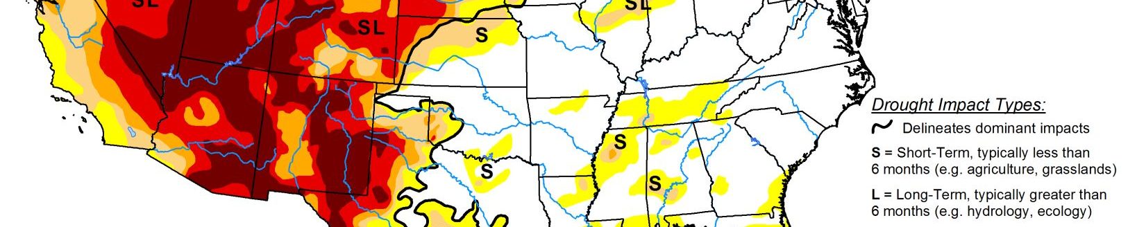
West
With precipitation limited to western Washington, northern Cascades, northern Idaho, and the Rockies (the Southwest and Intermountain West were dry), only some slight improvements were made. This included central Washington (very slight reduction of D0-D2 on west side), while some D0 was removed in northern Idaho and western Montana as underlying soils were moist, and impressive mountain snows have started the Water Year. No other improvements were done, except for some small D3 to D2 changes in central Colorado due to beneficial storm totals in Huerfano and Costilla counties, and near Ft. Collins and Boulder areas. In the Southwest, California, and Intermountain West, since October is normally dry, temperatures had dropped, and extensive deteriorations had already been made during the past several months, no degradations were made this week. Unfortunately, large wild fires continued to spread and expand in California thanks to gusty Santa Ana winds. As the southern Rockies storm continued past Day7, any additional precipitation and possible improvements after the Tuesday 12 UTC cutoff will have to wait until next week in New Mexico and Colorado.