In some areas of the country, storms chipped away at dryness and drought. Notably, on the 10th, Nicole became the first November hurricane to make landfall on the U.S. mainland since 1985, when Kate struck near Mexico Beach, Florida, on Nov. 21. Nicole, a Category 1 hurricane with sustained winds near 75 mph, moved ashore just south of Vero Beach, Florida, around 3 a.m. EST.
Farther west, a storm system produced heavy snow and local blizzard conditions in the north-central U.S., while parts of the West received drought-easing precipitation. However, many other areas of the country remained mostly dry. Frigid conditions developed in conjunction with the Western storminess and expanded eastward, while much of the lingering warmth in the South and East was swept away, shortly after Nicole’s departure.
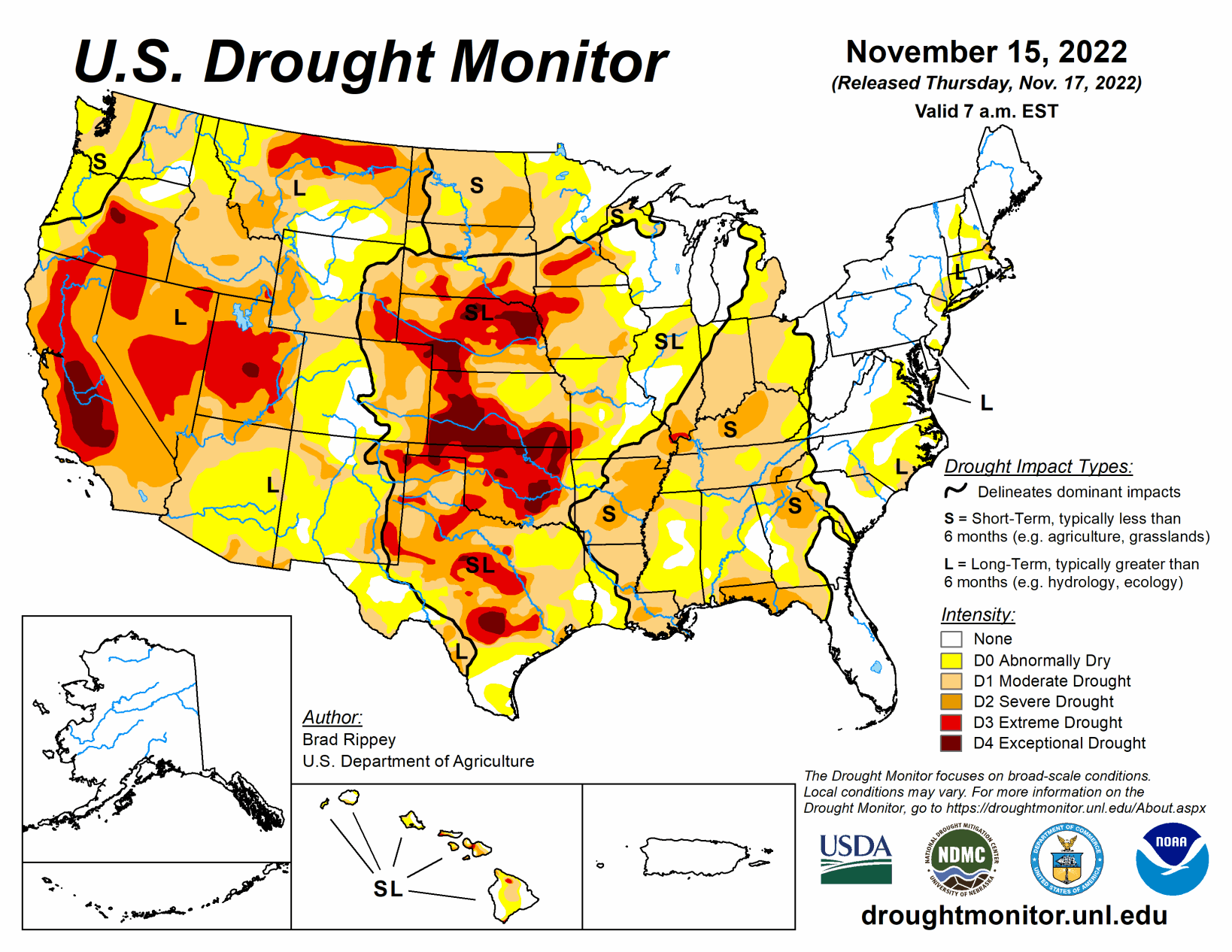
South
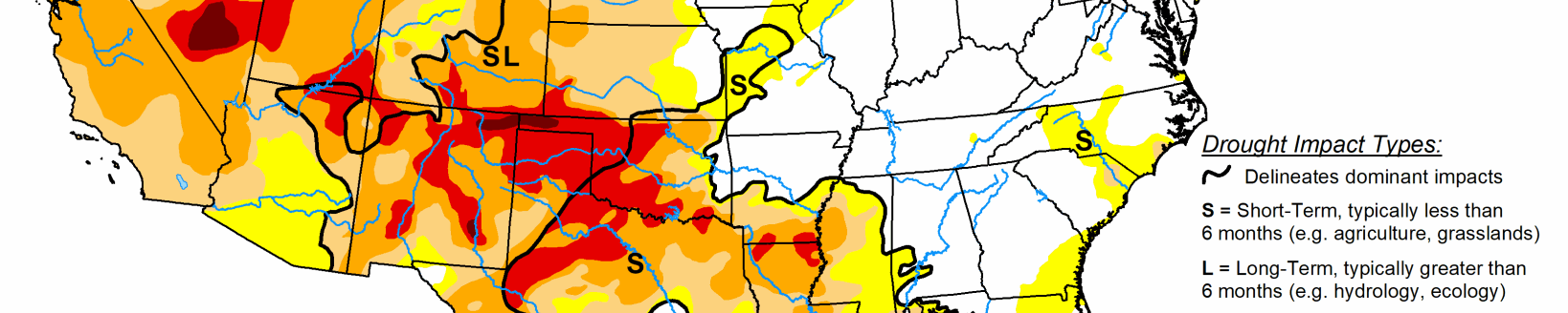
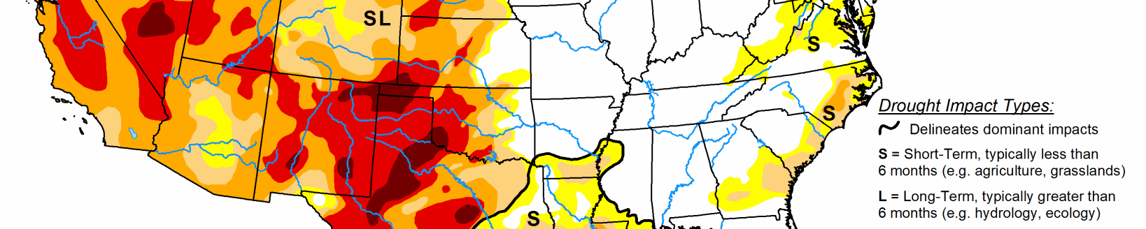
Late in the drought-monitoring period, precipitation developed across eastern sections of Oklahoma and Texas before spreading into the lower Mississippi Valley. Targeted reductions in drought coverage up to one category were made where the heaviest rain fell. However, much of the region received little or no precipitation. By Nov. 13, the U.S. Department of Agriculture rated topsoil moisture at least one-half very short to short in Oklahoma (76%), Texas (71%), and Louisiana (58%). On the same date, the recently planted winter wheat crop continued to struggle in the driest areas, with 48% of the crop rated in very poor to poor condition in Texas, along with 42% in Oklahoma. In Arkansas, only 59% of the winter wheat had emerged by Nov. 13, compared to the 5-year average of 66%. Rangeland and pastures continued to reflect the effects of drought, with 82% rated in very poor to poor condition in Oklahoma, along with 62% in Arkansas, and 57% in Texas.
Midwest
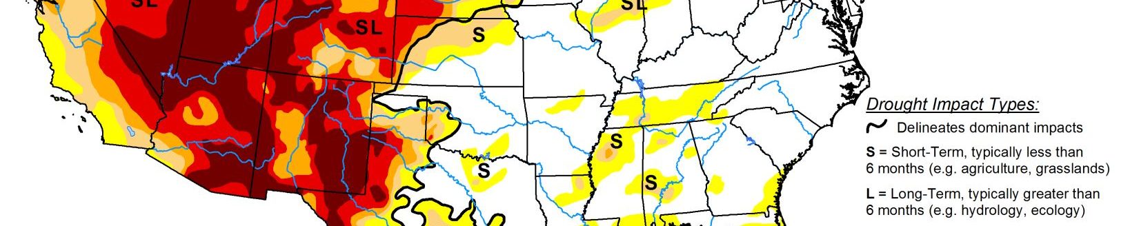
Heavy precipitation in the upper Great Lakes region provided drought relief, but many other areas of the Midwest experienced dry weather. Eastern Michigan was one area that had a notable increase in the coverage of abnormal dryness (D0) and moderate drought (D1). In contrast, heavy rain associated with the remnants of Hurricane Nicole fell in eastern sections of Ohio and Kentucky. Zanesville, Ohio, received a daily-record rainfall total of 2.20 inches on Nov. 11. A day earlier in Minnesota, a winter-like storm system had delivered daily-record precipitation totals to Minnesota locations such as Hibbing (1.35 inches) and Brainerd (1.27 inches). Even with nearly an inch of rain falling in Minneapolis-St. Paul, Minnesota, from Nov. 8 to 10, the Twin Cities’ year-to-date precipitation remained more than 9 inches below normal. Minneapolis-St. Paul measured a daily-record snowfall (2.5 inches) on Nov. 14. The following day, record-setting snowfall totals for the 15th included 3.5 inches in Waterloo, Iowa, and 2.8 inches in Madison, Wisconsin.
High Plains
An early season winter storm produced significant, wind-driven snow and freezing rain across parts of the Dakotas. Officially, 17.0 inches of snow—with a liquid equivalency of 1.23 inches—blanketed Bismarck, North Dakota, on Nov. 10, accompanied by wind gusts as high as 37 mph. Elsewhere in North Dakota, wind gusts at the height of the storm reached or exceeded 40 mph in Garrison, Jamestown, and Minot. Bitterly cold weather trailed the storm.
The northern Plains’ moisture, while highly beneficial for winter wheat, had a limited immediate effect on the drought situation, leading to only small improvements in the depiction. Farther south, drought continued to gradually worsen in other parts of the region. On Nov. 13, the U.S. Department of Agriculture reported topsoil moisture rated very short to short ranging from 65% in North Dakota to 87% in South Dakota. On the same date, winter wheat across the region remained in dismal condition, with more than one-third of the crop rated very poor to poor in Colorado (45%), Kansas (40%), Nebraska (38%), and South Dakota (37%).
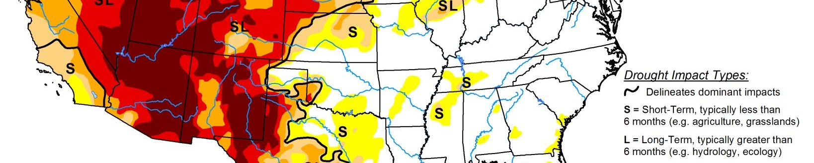
West
Over the past couple of weeks, beneficial precipitation has helped to establish high-elevation snowpack and has provided limited relief from long-term drought. The improved moisture has also benefited winter grains and cover crops. The latest round of significant rain and snow overspread much of the region early in the drought-monitoring period and lasted for several days. On Nov. 7, the last full day of the previous period, Spokane, Washington, measured a daily-record snowfall of 3.8 inches. Also on the 7th, Elko, Nevada, set daily records for precipitation (0.76 inch) and snowfall (7.5 inches). Elko’s Nov. 7 to 9 snowfall reached 13.1 inches. Similarly, Alta, UT, noted a 3-day (ending Nov. 10) storm total of 27.7 inches.
Sub-zero temperatures were common across the northern Rockies and northern Intermountain West, with Greybull, Wyoming, reporting five consecutive readings below 0°F from Nov. 10 to 14, along with a daily-record low of -14°F on the 11th. In Glasgow, Montana, a daily-record low of -15°F on Nov. 10 was preceded and accompanied by 11.5 inches of snow, starting on the 8th. Other sub-zero, daily-record lows in Montana included -15°F (on the 8th) in Great Falls and -17°F (on the 11th) in Miles City.
Related Articles