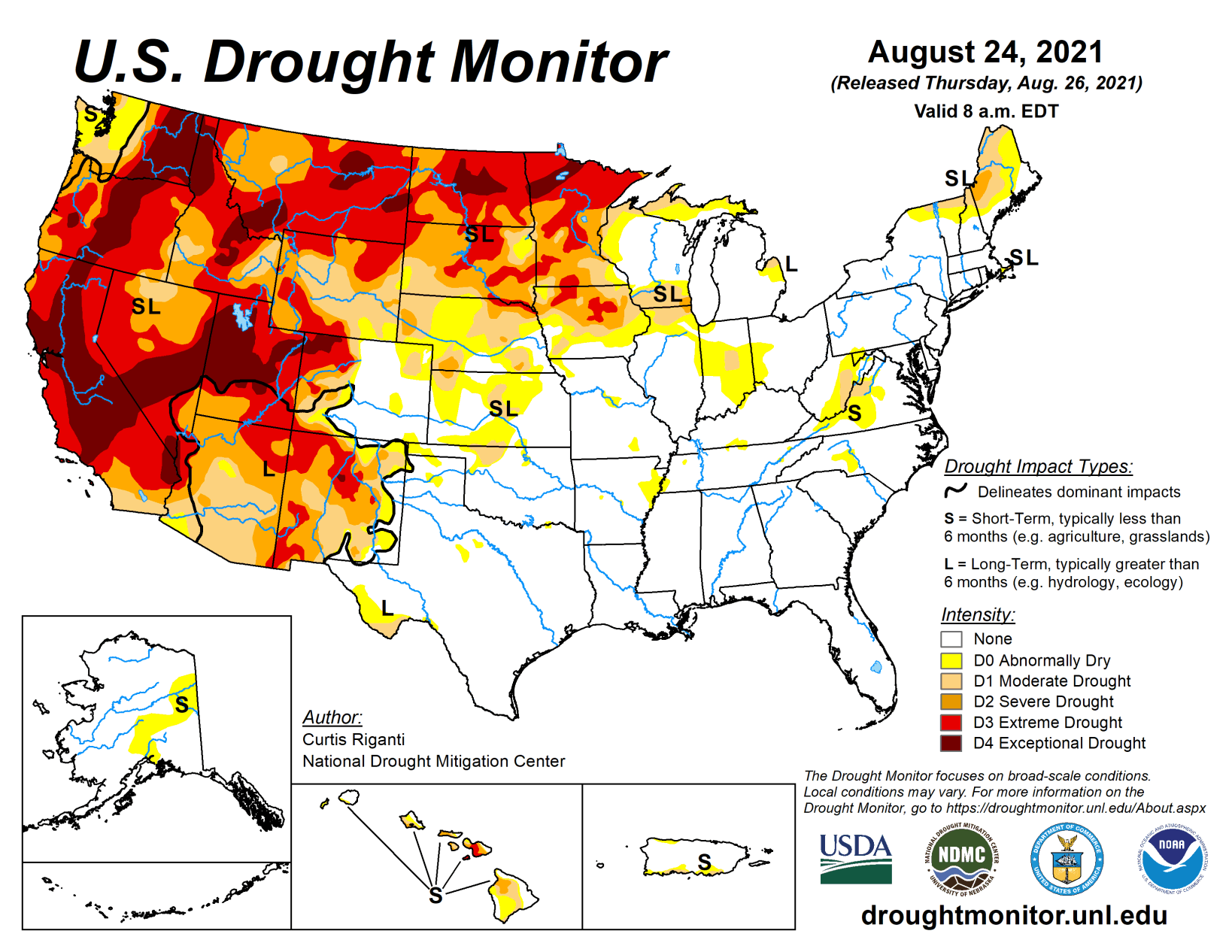
Beneficial rainfall in Midwest, High Plains and west improves drought conditions in some areas

Temperatures this week were generally cooler than normal west of the Continental Divide, while warmer than normal temperatures were common in the Upper Midwest and Northeast. Heavy rain fell across widespread sections of the eastern United States, in many locations due to the influences of tropical cyclones Fred and Henri and their remnants. The widespread rainfall led to condition improvements in areas suffering from abnormal dryness or moderate drought. Tragically, this led to a flash flood event with numerous fatalities in Tennessee.
Parts of the Midwest, High Plains, and West regions received beneficial rainfall this week, which led to improvement in drought conditions in some locales. Many locations across the central United States that missed out on heavier rains this week saw drought conditions degrade.
South
Heavy rains fell this week across parts of central and northeast Texas (and adjacent southeast Oklahoma), in much of central and eastern Tennessee, and in northern Mississippi and Louisiana. A small area of short-term moderate drought straddling the Red River in southeast Oklahoma/northeast Texas received sufficient rainfall to see conditions improve out of drought. Heavy rainfall led to the removal of moderate drought in parts of eastern Tennessee. Northwest Oklahoma was left drier this week, and small areas of short- and long-term moderate drought expanded there and in adjacent southern Kansas. Temperature departures varied across the region and generally were not extreme in either the warm or cool direction.
Midwest
Weather conditions varied widely across the Midwest this week. As a common denominator, the entire region saw warmer than normal temperatures, with the warmest temperature departures (from 6 to 10 degrees above normal) taking place in Michigan and Minnesota. Rain fell across roughly the southwestern half of Missouri, Iowa (north of Interstate 80), the western two-thirds of Minnesota), far southeast Ohio, and Kentucky, as well as a few other isolated spots in southern Illinois. Elsewhere, the weather was largely dry. Very dry weather over the last month, and associated impacts to soil moisture, led to the formation of short-term moderate drought in central Indiana. Recent dry conditions also led to expansion of moderate drought in northern Wisconsin and the Michigan Upper Peninsula.
Recent heavy rain allowed for some improvements in drought areas in Iowa and Minnesota (where the heaviest amounts occurred to alleviate very short-term dryness), but longer-term deficits and impacts to the hydrologic system remain across the greater part of the two states. The Boundary Waters Canoe Area Wilderness in northern Minnesota closed recently due to a nearby wildfire. The ongoing drought has also adversely affected bee populations and honey production. Low streamflow in rivers in Minnesota remained a problem this week. In some areas of northeast and southwest Minnesota that didn’t see much or any rain this week, extreme drought widened its footprint.
High Plains
In the High Plains region this week, temperatures were mostly below normal west of the Continental Divide in Colorado, in Wyoming, and in far western parts of South Dakota and North Dakota. Elsewhere, temperatures were generally above normal. Rain fell over wide areas of Nebraska, South Dakota, North Dakota, Wyoming, and western Colorado, leading to some improvements in drought conditions.
Parts of the Missouri River Valley in northeast Nebraska, northwest Iowa, and southeast South Dakota did not see much rain, however, and moderate, severe, and extreme drought expanded there. Heavy rain, with some areas seeing 5 or more inches, struck northeast Colorado and southwest Nebraska, though as is typical of warm season thunderstorm complexes, rainfall gradients were rather tight in some areas. Drought conditions improved in areas that saw heavy rain, while some expansion of severe drought occurred in areas of southwest Nebraska that missed out on the rain, where agricultural drought impacts and precipitation deficits have been mounting. Heavy rainfall in North Dakota led to some localized improvements to ongoing drought, though some short-term and especially long-term precipitation deficits remain in areas which received heavy rain. Ongoing drought also impacted the bee population in North Dakota.
West
Drought continued to plague much of the West region of the United States this week. Heavy rains in parts of Arizona, Idaho, Montana, and Utah combined with well below normal temperatures (ranging from 4 to 8 degrees below normal) to stave off any expansion or worsening of drought areas this week. Due to recent monsoonal rainfall, drought conditions improved in northern Arizona and southern Utah, and adjacent parts of southern Nevada and southeast California, and in New Mexico. Heavy rain in the far northern Idaho Panhandle led to a small reduction in exceptional drought coverage. It is possible that conditions may continue to improve in some locations after this week’s rainfall, though it is currently unknown how beneficial this week’s rains were in locations that were quite dry previously.


