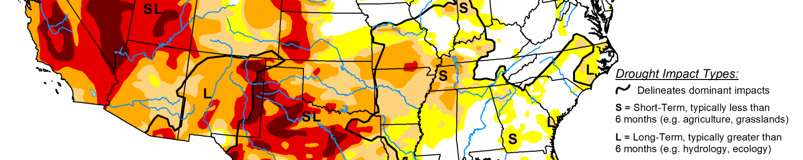
Several storm systems impacted various regions of the country this week as the transition to autumn continues. Temperatures through the Midwest and northern Plains remained unseasonal with departures of 9-12 degrees above normal.
As cooler air came into the West, temperatures were 3-6 degrees below normal in the region and into the Southwest. The Pacific Northwest had several rain events that brought needed moisture into the region. Areas of eastern Arizona, New Mexico and Colorado also had above-normal precipitation for the week. A slow-moving cold front brought with it a line of showers from the Dakotas into Texas. This slow-moving rain maker brought relief to many dry areas of the Plains. Dry conditions dominated the northern Rocky Mountains as well as the coastal regions of the East from the Mid-Atlantic into Florida.
Midwest
Temperatures were warm in the region with almost the entire area above normal for the week. Most areas were 4-8 degrees above normal, but portions of northern Minnesota, eastern Iowa and northern Illinois were 12-16 degrees above normal. Precipitation was scattered, but those areas that did receive it saw amounts up to 400% of normal for the week. It remained dry over eastern Iowa, southeast Minnesota, and central Ohio as well as northwest Missouri. Abnormally dry conditions were improved over portions of central and southern Missouri and western Indiana. Widespread improvements were made over much of Minnesota, but even with the recent wetter pattern, lake levels across the state remain low. Abnormally dry conditions were expanded over northern Wisconsin into the Upper Peninsula of Michigan. Abnormally dry conditions were also expanded over northern Missouri and into southern Iowa while moderate and severe drought conditions were expanded over portions of Iowa and northern Illinois.
High Plains
Significant rains fell over portions of western and central Kansas, central and northeast Nebraska and into central South Dakota as well as southeast North Dakota. Temperatures were warm over almost the entire region with departures of 9-12 degrees above normal in North Dakota and northern areas of South Dakota, and generally 3-6 degrees above normal elsewhere.
Those areas that have been in long-term drought will continue to see challenges to pasture and rangeland conditions as well as available forage. Hay stockpiles continue to decline and will be more expensive on the open market compared to past years. Improvements to the drought status were made in areas that received the most rain and the indicators showed improvements. In South Dakota, extreme and severe drought was improved in the south and north areas while moderate drought and abnormally dry conditions were improved in the east.
Where it remained dry in the western portions of the state, extreme and severe drought were expanded this week. In Nebraska, the dryness over the Panhandle remained a concern and a new area of extreme drought was introduced this week that went into southeast Wyoming. Areas of improvement were confined to central and southwest Nebraska where moderate drought and abnormally dry conditions were improved in response to the recent rains. Areas of eastern Colorado had moderate drought conditions expand this week while severe drought expanded in far southeast Colorado and into southwest Kansas. Areas of northwest Kansas saw improvements of abnormally dry and moderate drought conditions this week.
South
Temperatures across the region were generally warmer than normal with departures of 4-6 degrees above normal common. In contrast to last week, much of the region did see some beneficial rains that put the brakes on the recent dryness. Some areas did miss out, with the Oklahoma and Texas panhandles, east and west Texas and western Arkansas being the driest. Much of the abnormally dry areas introduced last week in Texas were improved this week with even some areas of moderate drought being removed in the south and central portions of Texas. Eastern Texas had an expansion of abnormally dry and moderate drought conditions, and in the Oklahoma panhandle, severe drought was expanded and a new area of extreme drought was introduced that also went into portions of southeast Colorado.
Severe drought was expanded slightly in north central Oklahoma where rains missed while other areas of central Oklahoma had improvements to the drought status this week. Most of northern Arkansas had precipitation that helped to improve the abnormally dry conditions, but the spottiness of the rains also means that some areas continue to dry out.
West
As the 2020-2021 water year ended, several places set records for driest years ever recorded. In northern California, Redding ended up with 14.24 inches, breaking the previous record low of 19.38 inches in 1990-91 and a normal of 33.52 inches. Red Bluff recorded 9.48 inches compared to the previous record of 10.98 inches in 1975-76 and a normal of 23.12 inches. The Sacramento Executive Airport recorded only 6.61 inches of precipitation for the water year, breaking the record from 1976-77 of 6.62 inches, with normal being 18.14 inches.
Rains in the Pacific Northwest and into the Four Corners regions were the only areas with above-normal precipitation for the week. The conditions brought with them cooler than normal temperatures with departures mainly 3-6 degrees below normal, with some even cooler readings in those areas that had the most rain. Warmer than normal conditions dominated the northern Rocky Mountains and into northern Wyoming where temperatures were 3-6 degrees above normal. Some improvements to the extreme drought were made over portions of northwest Colorado into eastern Utah. Extreme drought was also improved over western New Mexico while moderate drought was improved in central New Mexico. Exceptional drought was improved over northeast Washington into northern Idaho while extreme drought was expanded over southern Montana into northern Wyoming with severe and extreme drought expanding over western Montana. Areas of southwest and southern Colorado had moderate and severe drought conditions expand.