Much above-normal temperatures plagued much of the central and eastern contiguous U.S. (this week from the Great Plains eastward to the Mississippi Valley and Southeast. The western third of CONUS, the Northeast, and coastal Mid-Atlantic experienced seasonal to below-normal temperatures. Precipitation was lacking in many locations that experienced excessive (in some cases record) heat, leading to widespread expansion of abnormal dryness and moderate drought conditions along the Mississippi and Ohio Valleys, the Southern Plains, and the Southeast.
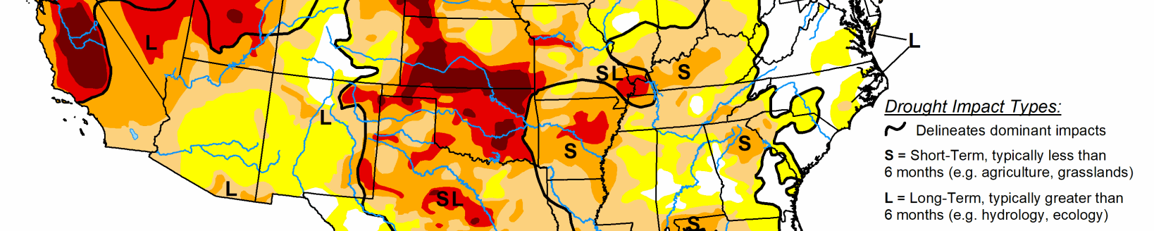
From the Central Plains northward, despite the excessive heat (daytime high temperatures above 100°F several days this week), recent improvements driven by an active storm track leading up to this week resulted in modest, more targeted degradations in the drought depiction. Another week of heavy rainfall warranted improvements in Montana.
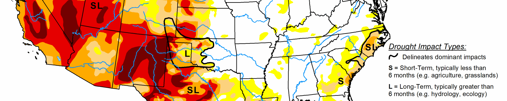
Heavy rainfall associated with the Southwest Monsoon also fell across parts of the Four Corners region. However, this only acted to halt any further degradations this week. Given drought is strongly entrenched in the Four Corners, an active Southwest Monsoon circulation will need to persist for conditions to improve.
South
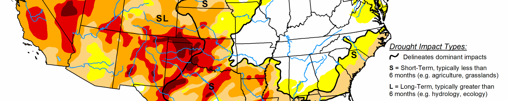
Extreme heat, high winds, and below-normal precipitation continued in Texas, leading to another round of degradations this week across the state. Extreme heat and below-normal precipitation also led to the widespread expansion and addition of abnormal dryness (D0) and moderate drought (D1) across the Lower Mississippi and Tennessee Valleys. Soil moisture conditions quickly deteriorated this week (falling below the 30th percentile across many areas that saw expansion). Additionally, daily and 7-day average USGS stream flows fell below-normal (below the 24th percentile) and vegetation indices are also indicating increased stress to plants. Short-term (30 to 60-day) deficits are starting to accumulate also, with many areas across the Lower Mississippi and Tennessee Valleys experiencing 4 to 6 inch rainfall deficits over the last 60 days.
Midwest
One-category degradations—expansion and/or introduction of abnormal dryness (D0), moderate drought (D1), and severe drought (D2)—were warranted across the Middle Mississippi Valley, Ohio Valley, and parts of the Corn Belt. Parts of the Ohio Valley have seen a gradual increase in precipitation deficits in the last 60 days. However, over the last month, there has been a more rapid decline in rainfall, with parts of the Middle Mississippi Valley experiencing 3 to 4 inch rainfall deficits in the last 30 days. NASA SPoRT is indicating widespread soil moisture rankings falling below the 20th percentile over a depth of 200 cm and daily USGS stream flows have shown a consistent decline in most areas. This week’s hot temperatures also led to very high evapotranspiration rates. One report out of Missouri estimated the total weekly loss of surface moisture to be around 1.75 inches.
High Plains
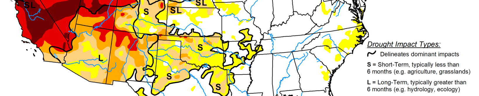
Much of the High Plains region has seen beneficial rainfall and temperatures averaging near to below-normal over the past 30 days, with the exception of a few locations. Some targeted improvements were warranted across parts of southeastern Nebraska this week, which picked up 1.5 to 3 inches of rainfall (per AHPS estimates). Targeted improvements were also made in parts of Colorado and northern Wyoming due to a robust Southwest Monsoon circulation and an active storm track across the Northern Tier, respectively. Conversely, high winds and hot temperatures, which exceeded 100°F several days this week, resulted in high evapotranspiration rates and, subsequently, degradations for parts of the Central Plains. Evapotranspiration rates approaching 0.5 inches per day were reported in western Nebraska.
West
Much of the Northern Tier of the U.S. from the Pacific Northwest to the Northern Plains has seen marked improvements in recent months due to a persistent storm track and near to below-normal temperatures. That same pattern continued this week, leading to 1-category improvements from the Pacific Northwest eastward to Montana. Improvements in Montana are the result of 7-day precipitation surpluses of more than 1 inch for many locations and near to below-normal temperatures. In the Pacific Northwest, long-term indicators continued to improve due to the recent storminess and below-normal temperatures leading up to this week.
In the Four Corners region, heavy rainfall was observed in a large swath stretching across western New Mexico, due to a robust Southwest Monsoon circulation. However, there were no marked improvements to drought indicators this week to warrant improvements. Given drought is strongly entrenched in the Four Corners, an active Southwest Monsoon circulation will need to persist for conditions to improve.