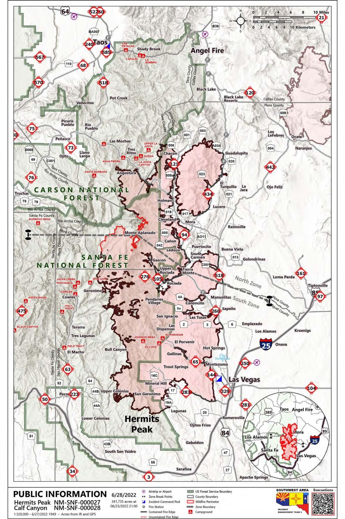
The Hermits Peak/Calf Canyon fire has reached 92% containment as of June 27, having burned 341,735 acres. The Hermits Peak fire started April 6 from spot fires from a prescribed burn, while Calf Canyon started April 19.
Officials say the cause of the Calf Canyon Fire was from a pile burn holdover from January that remained dormant under the surface through three winter snow events before re-emerging in April. A holdover fire, also called a sleeper fire, is a fire that remains dormant for a considerable time.
Suppression of New Mexico’s largest wildfire was due to the work of firefighters and monsoonal rain showers June 25 and 26. Some areas of the Carson National Forest and Santa Fe National Forest remain closed to allow for suppression efforts.
According to inciweb.nwcg.gov, the northern zone of the fire has not had any movement in the uncontained western edge. Firefighters continue fixing fences and repairing roads from suppression efforts in Mora, Holman, Guadalupita, Chacon, along the NM Highway 518 and 434 corridors, and in other areas as well. The entire northern fire area has received rainfall from the recent storms, tempering the heat inside the fire perimeter.
Flash floods are still a concern in San Miguel and Mora counties, and a rapid response crew has been monitoring waterways for debris buildup, and are available for emergency response to protect life and property. Saturated roadways are preventing firefighters from accessing areas of the fire and are also impacting the ability to remove heavy equipment from those areas. Firefighters will continue to assist with any new fire starts in the temporary flight restriction area of the fire.
In the southern zone, crews were able to increase some containment in some of the interior islands of the western edge of the fire east of Geronimo, New Mexico. Aerial resources are mostly grounded due to weather and are expected to be limited June 27 as moisture continues. Crews will continue to work on containment and suppression repair as weather allows.
On June 25, InciWeb reported a phase 3 post-fire Burned Area Emergency Response assessment began on the Hermits Peak/Calf Canyon fires on the east side of the Sangre de Cristo Mountains.
There are three phases of recovery following wildfires on federal lands. First is fire suppression repair. This is a series of immediate post-fire actions taken to repair damages and minimize potential soil erosion and impacts resulting from fire suppression activities and usually begins before the fire is contained, and before the demobilization of an Incident Management Team. This work repairs the hand and dozer fire lines, roads, trails, staging areas, safety zones, and drop points used during fire suppression efforts.
Second is emergency stabilization of the BAER. This phase is a rapid assessment of burned watersheds by a BAER team to identify imminent post-wildfire threats to human life and safety, property, and critical natural or cultural resources on National Forest System lands and take immediate actions to implement emergency stabilization measures before the first post-fire damaging events. Fires result in loss of vegetation, exposure of soil to erosion, and increased water runoff that may lead to flooding, increased sediment, debris flows, and damage to critical natural and cultural resources. BAER actions such as: mulching, seeding, installation of erosion and water run-off control structures, temporary barriers to protect recovering areas, and installation of warning signs, may be implemented. BAER work may also replace safety related facilities; remove safety hazards; prevent permanent loss of habitat for threatened and endangered species; prevent the spread of noxious weeds and protect critical cultural resources.
Finally, long-term recovery and restoration utilizes non-emergency actions to improve fire-damaged lands that are unlikely to recover naturally and to repair or replace facilities damaged by the fire that are not critical to life and safety. This phase may include restoring burned habitat, reforestation, other planting or seeding, monitoring fire effects, replacing burned fences, interpreting cultural sites, treating noxious weed infestations, and installing interpretive signs.
Preliminary analysis suggests Pecos River headwaters to the Dalton Day Use/Southern forest boundary are susceptible to post-fire flooding that may pose a risk to public safety. Officials are expecting additional elevated flows along the Pecos River to the southern forest boundary to the confluence of Canon de los Trigos.
The BAER team continues to coordinate and share information from its assessment with other federal agencies, including the Natural Resources Conservation Service, National Weather Service and U.S. Geological Survey as well as state agencies and local counties and municipalities who work with adjacent and downstream private homeowners, landowners, and businesses to prepare for potential post-fire flooding and debris flow impacts. NRCS is a federal agency that has post-fire responsibilities on private lands both within and downstream of burned areas.
Homes or businesses that could be impacted by flooding from federal land that result from wildfires may be eligible for flood insurance coverage from the National Flood Insurance Program. Information about NFIP is available through FEMA at www.fema.gov/national-flood-insurance-program, or www.floodsmart.gov/wildfires. Other flood preparedness information is available at www.ready.gov/floods at www.floodsmart.gov/.
For more information about the Hermits Peak/Calf Canyon fire visit https://inciweb.nwcg.gov/incident/8069/.
Kylene Scott can be reached at 620-227-1804 or [email protected].