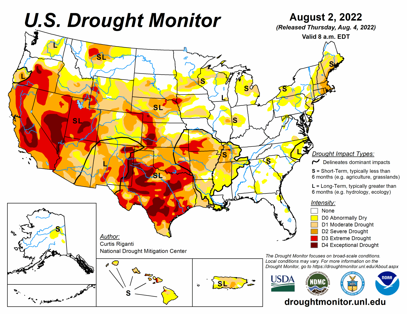
Weather and drought conditions varied widely in the contiguous U.S. this week. From the Desert Southwest and southern Colorado eastward into the Texas Panhandle, western Kansas, eastern Colorado, northern Oklahoma, and Arkansas, heavy rainfall fell in some areas, leading to localized improvements in ongoing drought.
Drier weather led to expansion of drought conditions in parts of the central Great Plains and Upper Midwest. Similar conditions in Texas led to expansion of drought conditions there, while recent precipitation led to some improvements in southwest Texas.
South
The South region saw highly variable weather this week. This led to a wide range of changes to the ongoing drought areas across the region. Temperatures across most of Texas were above normal for the week, with many readings of 4 to 8 degrees above normal. Temperatures across the rest of the South were more moderate, generally within 4 degrees of normal on either side. Heavy rainfall occurred from the central and northern Texas Panhandle eastward through the northern half of Oklahoma, Arkansas, northern Mississippi, and portions of Tennessee.
This led to improvements in the Texas Panhandle, northern Oklahoma, Arkansas, Tennessee, and Mississippi. Conditions also improved a bit in southwest Texas, where recent rainfall began to alleviate short- and long-term precipitation deficits. Meanwhile, short-term drying combined with above-normal temperatures to worsen drought conditions across some other parts of Texas and Oklahoma. Drought impacts across Texas ranged from crop failure to water supply problems, in one case from a well failure.
Midwest
Weather and drought conditions varied substantially in the Midwest region this week. Heavy rainfall in central Missouri and parts of southern Missouri, southern Illinois, southern Indiana, and Kentucky led to more flash flooding in the region, including a devastating flash flood in southeast Kentucky. More minor rainfall occurred across parts of northeast Minnesota. Otherwise, the region generally saw below-normal rainfall for the week. Notably, some areas of south-central Missouri missed out on heavy rains in nearby areas, worsening the flash drought situation and leading to localized expansions of extreme drought.
Temperatures were near or up to 4 degrees below normal in most of the Midwest, with the exception of parts of south-central and southwest Missouri, which saw temperatures that were mostly a couple degrees warmer than normal. Drought conditions developed or worsened in a few parts of the Upper Midwest that missed out on heavier rains and saw precipitation deficits worsen. This included parts of southern and western Iowa, northern Wisconsin, the Michigan Lower Peninsula, and central Minnesota. In Wisconsin, the Fox River Cruise Company ran into problems docking due to low water levels.
High Plains
Moderate to heavy rains fell this week across portions of Colorado and western Kansas, related to an active North American Monsoon. Aside from other localized pockets of moderate to heavy rain, the High Plains region saw mostly dry weather this week. Temperatures from 2 to 4 degrees below normal were common across most of Kansas, southeast Colorado, central and eastern Nebraska, eastern South Dakota, and North Dakota this week.
Near-normal temperatures mostly prevailed elsewhere, with parts of western Wyoming experiencing temperatures from 2 to 6 degrees above normal. The heavier rains in Colorado and western Kansas led to some improvements in ongoing drought, with localized removal of drought occurring, as precipitation deficits lessened. Conditions worsened in parts of southwestern, central, eastern, and northern Nebraska, and in adjacent southern South Dakota, where deficits in soil moisture and precipitation worsened. In Columbus, Nebraska, the Platte River ran dry, indicative of the moderate and severe drought conditions ongoing in and near the eastern Nebraska town. Two reservoirs in eastern Colorado are expected to run dry soon due to drought and water demand from irrigation.
West
In the West region, moderate to heavy rain fell across parts of Arizona, New Mexico, Utah, Nevada, and far southeast California. In locations where long-term rainfall deficits, soil moisture, and groundwater improved substantially, ongoing drought conditions improved locally. A south-to-north temperature gradient set up this week, with temperatures in Arizona and southern Nevada coming in 3 to 6 degrees below normal in spots, while a heat wave developed in the Pacific Northwest, pushing temperatures more than 9 degrees above normal in parts of northern California, Oregon, and Washington. In southeast and east-central Oregon, the evaporative stress from the heat locally worsened drought conditions. A myriad of drought impacts continued in the West this week, including wildfires in northern Utah and a central California reservoir dropping to its lowest level in 5 years.


