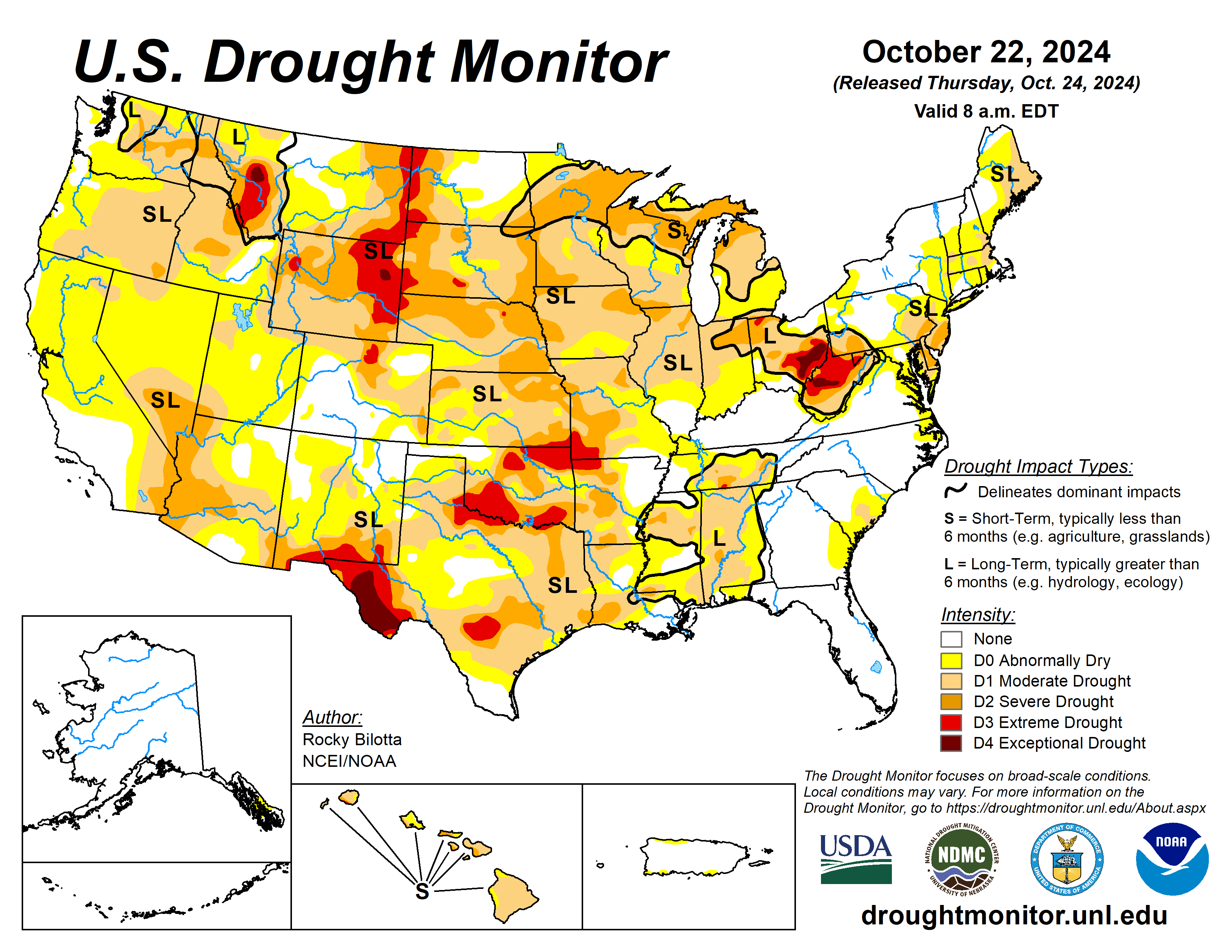
Precipitation fell across much of the United States over the past week, while heavier amounts were observed over parts of the Pacific Northwest and Southwest. Portions of New Mexico, Utah, Colorado and Washington reported rainfall totals between 3 to 5 inches above normal, while precipitation totals were below normal across much of the eastern U.S.
Warmer-than-normal temperatures were observed across much of the country. Temperature departures ranging between 6 to 15 degrees Fahrenheit above normal were observed from the northern Rockies to northern portions of the Midwest. Cooler-than-normal temperatures were observed from eastern portions of Texas to the Mid-Atlantic, and in parts of the Southwest. The Southeast observed temperatures between 3 to 9 degrees below normal.
The U.S. Drought Monitor is jointly produced by the National Drought Mitigation Center at the University of Nebraska-Lincoln, the U.S. Department of Agriculture and the National Oceanic Atmospheric Administration. (Map courtesy of NDMC.)
South
Dry conditions continued across much of the South this week, while precipitation fell just along the western borders of Texas, Oklahoma and Kansas. Temperatures were mixed across the region with the eastern areas experiencing below-normal temperatures, with departures of 1 to 9 degrees below normal, and above-normal temperatures were observed across western portions of the South, with departures of 1 to 6 degrees above normal.
Moderate to severe drought were expanded across portions of Texas, Oklahoma and northern Arkansas. The expansion and intensification of drought categories were based on short-term SPI/SPEI, reservoir levels, streamflow and soil moisture data.
Midwest
Temperatures varied across the Midwest with above-normal temperatures being observed in the northern portions of the region, while southern portions experienced below-normal temperatures. Precipitation fell over portions of the Midwest but rainfall totals were below normal for the region. Above-normal temperatures, along with below-normal precipitation, resulted in the expansion of drought and abnormal dryness across much of the region.
Moderate to severe drought was expanded across much of Minnesota and Missouri and in parts of Iowa. Abnormal dryness was expanded in eastern Missouri.
High Plains
Warm temperature dominated the High Plains this week with departures ranging up to 12 degrees above normal, especially in the northern portions of the region. Precipitation fell across much of the region this week, but amounts were not large enough to prevent further degradations across much of the region.
Extreme drought was introduced in northeast Nebraska, while extreme drought was expanded in western South Dakota, eastern Wyoming, and northwestern Nebraska. Severe and moderate drought were expanded in portions of Kansas, Nebraska, and the Dakotas, while severe drought was expanded in southern Wyoming. The heaviest rains fell across Colorado, reporting rainfall totals up to 600% of normal, resulting in improvements of moderate to severe drought and abnormal dryness in western and southern portions of the state.
West
Average temperatures were mostly above normal across the West. New Mexico experienced below-normal temperatures, with departures of 1 to 6 degrees below normal. Conversely, Montana observed temperatures ranging between 3 to 12 degrees above normal. Precipitation fell across much of the region but amounts were mostly normal to below-normal for the region. Heavier rainfall totals, up to 600% above normal, were observed over parts of New Mexico. Daily maximum precipitation records were set in parts of Utah and New Mexico.
Above-normal precipitation (up to 8 inches above normal), along with cooler temperatures, allowed drought and abnormal dryness improvements in New Mexico. Warmer-temperatures and below-normal precipitation resulted in expansion of moderate to extreme drought and abnormal dryness in eastern Montana based on SPI/SPEI data, as well as low soil moisture and streamflow values.
Looking ahead
During Oct. 22 to 26, the cold front crossing the Great Lakes and into the Northeast Wednesday into early Thursday will likely have just enough moisture and lift to produce some mainly light to moderate showers, while conditions should continue to remain dry and mostly sunny for areas farther to the south across the Mid-Atlantic and the Southeast U.S. Moisture is forecasted to return to the Pacific Northwest late this week into the weekend, with rain and high elevation northern Cascades snow could commence as early as late Thursday.
Temperatures will feel more like September across areas from the central U.S. into the Northeast Tuesday into Wednesday, with highs running 10 to 20 degrees above average for late October and possibly even a little higher over parts of the Upper Midwest/northern Great Lakes on Tuesday. A cold front pushing rapidly eastward from the northern Plains will bring more seasonable conditions after midweek.
From late week into the weekend, a building Western U.S. upper ridge that pushes eastward ahead of the Pacific storm system should promote a warming trend first over the Intermountain West and Rockies/western High Plains and then covering much of the central U.S. where many areas should see highs 10 to 20 degrees above normal. The West Coast states should be within a few degrees on either side of normal aside from a brief warmer period over parts of California around midweek.
The Climate Prediction Center’s 6- to 10-day outlook valid Oct. 27 to 31, favors above-normal precipitation from parts of the Midwest to the West Coast, with below-normal precipitation favored from the Tennessee Valley to the Northeast, as well as parts of the Southwest. Increased probabilities for above-normal temperatures are forecast for much of the contiguous U.S.
Rocky Bilotta is with the National Oceanic Atmospheric Administration and National Centers for Environmental Information.


