Moisture brought improvement made in drought-related regions
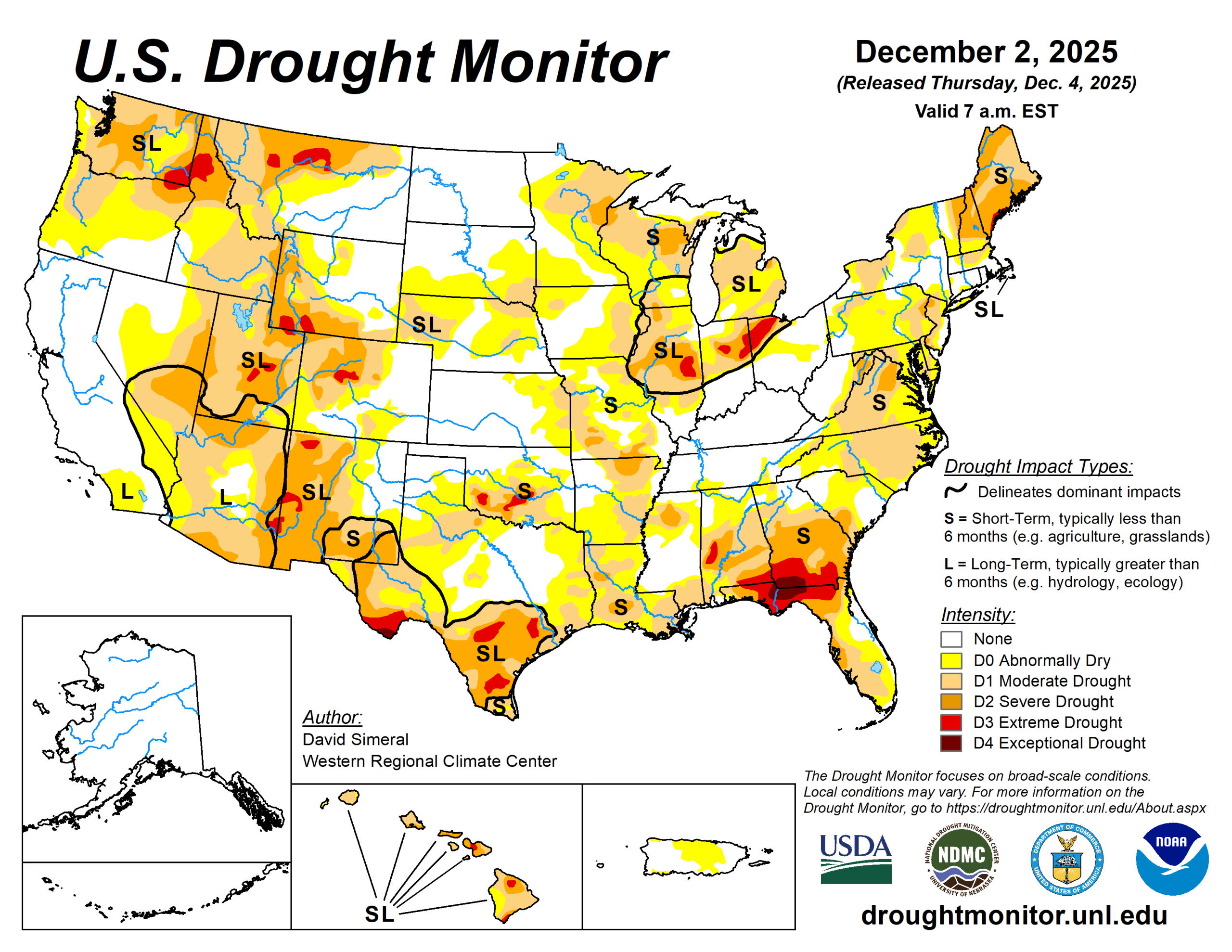
The U.S. Drought Monitor saw improvement in drought-related conditions across areas of the West, Plains, Midwest, South, Southeast, and the Northeast.
Improvements continued in areas of eastern California and southern Nevada, where conditions since the beginning of the water year (Oct. 1) have improved significantly. As of early December, mountain snowpack conditions continue to be well below normal levels for the time of year across much of the western United States, except for isolated areas of the Southwest and southern Rockies, where recent storms have boosted snowpack conditions well above normal levels.
As of Dec. 2, the Natural Resources Conservation Service SNOw TELemetry network reported the following region-level (2-digit HUC) snow-water equivalent levels: Pacific Northwest 43%, Missouri 47%, Upper Colorado 53%, Great Basin 39%, Lower Colorado 121%, Rio Grande 64%, and Arkansas-White-Red 53%.
In California, the statewide snowpack was 39% of normal (December 3), with the Southern Sierra at 78%, Central Sierra at 36%, and Northern Sierra at 17%. Elsewhere on the map, conditions continued to improve in drought-affected areas of central and northeastern Texas, where precipitation during the past month has been above normal. In the Northern Plains, Midwest, and Northeast, moderate-to-heavy snowfall accumulations provided some minor relief to drought-affected areas.
The U.S. Drought Monitor is jointly produced by the National Drought Mitigation Center at the University of Nebraska-Lincoln, the U.S. Department of Agriculture and the National Oceanic Atmospheric Administration. (Map courtesy of NDMC.)
South
On this week’s map, widespread improvements were made in drought-affected areas of Texas, while isolated areas of Oklahoma saw minor improvements in response to rainfall activity.
The heaviest rainfall accumulations were observed in isolated areas along the Gulf Coast of southeastern Texas, while lesser accumulations (ranging from 1 to 2 inches) were observed in other areas of the region including eastern and southern Texas, southeastern Oklahoma and southern Arkansas. In western Texas, conditions on the map deteriorated in response to drier-than-normal conditions during the past 90-day period.
Looking at climatological rankings for the past 30-day period (Nov. 2 to Dec. 2), Austin, Texas, was 10th driest (-2.3-inch departure) and College Station, Texas, ninth driest (-2.54 inches.
Water for Texas (Dec. 3) reported statewide reservoirs at 74% full. Numerous reservoirs in the eastern part of the state were in very good condition. Several reservoirs in the southern and western portion of the state were experiencing continued below-normal levels, including at Falcon Reservoir along the Rio Grande River (15.9% full).
In terms of drought-related impacts, the National Drought Mitigation Center’s Conditions Monitoring Observer Reports tool showed numerous impact reports during the past 30-day period with the highest concentration of reports yielding from southern Oklahoma, northern Arkansas, and northern Louisiana. Average temperatures were below normal across most the region with anomalies ranging from 4 to 10 degrees Fahrenheit above normal.
Midwest
Improvements in Iowa were made in response to recent snowfall activity, impacting a large portion of the region.
For the week, average temperatures were below normal across the entire region, with anomalies ranging from 2 to 15 degrees below normal, with the greatest departures observed in southwestern Minnesota, northwestern Iowa and west-central Illinois.
High Plains
Only minor changes were made in the region. In eastern Kansas, two areas of lingering Moderate Drought were removed in response to improving conditions during the past 90-day period.
Some beneficial snowfall was observed across the northern Plains, with accumulations ranging from 1 to 14 inches. The highest accumulations were logged in areas of North Dakota. In terms of average temperatures, cooler-than-normal temperatures (5 to 20+ degrees below normal) were observed across the region, with the greatest anomalies observed in the Dakotas.
According to NWS NOHRSC, the Upper Midwest region is currently 94.4% covered by snow (area) with an average depth of 3.7 inches and a maximum depth of 22.2 inches.
West
Recent storms and overall improving conditions on short-term indicators (precipitation, soil moisture, streamflows) led to improvements on the map in California (eastern Sierra, Mojave Desert), Nevada (west-central, southern), Utah (southwestern), Wyoming (central, southwestern), Montana (northwestern, central, northeastern), and Washington (southeastern).
Conversely, degradations were made on the map in areas of Oregon (central, southern), Idaho (west-central), Wyoming (southeastern), Colorado (central, north-central), and New Mexico (southeastern). For the week, most of the region experienced dry conditions except for portions of the Pacific Northwest and isolated areas in the central and northern Rockies. In terms of the snowpack, below-normal SWE levels are being observed at SNOTEL stations across most of the West, except for areas in the southern Sierra, Colorado Plateau, and southwestern Colorado.
In California, the NWS Forecast Office in Los Angeles is reporting that November was one of the wettest Novembers in the last 50+ years across southwestern California. Moreover, the city of Santa Barbara has reported the wettest water-year start on record through November with over 9.5 inches observed. Other areas in Santa Barbara County, including areas of the Santa Ynez Mountains, have received over 15 inches for the contemporaneous period.
Looking ahead
The National Weather Service’s 7-day quantitative precipitation forecast calls for the heaviest rainfall (2 to 5 inches) to be along the central Gulf Coast, including southern Louisiana, southern Mississippi, southern Alabama, and the western Florida Panhandle, while 1 to 4 inches is expected in southern Georgia and areas of coastal South Carolina.
The southern extent of the Mid-Atlantic coast is forecast to receive 1 to 3 inches, while New England is expected to have totals less than 1 inch. In the Pacific Northwest, 2 to 7+ inches (liquid) of precipitation is expected across western portions of Washington and Oregon, while the northern Rockies—including northern Idaho, western Montana, and western Wyoming—are forecast to receive liquid totals ranging from 1 to 3 inches.
These values represent liquid precipitation and may fall as rain or snow; actual snowfall amounts will vary depending on temperature and snow-to-liquid ratios. Meanwhile, much of the Intermountain West, Desert Southwest, and the central and southern Great Basin is expected to remain mostly dry, although northern portions of Utah and Colorado are forecasted to observe totals ranging from 0.25 to 2 inches. Across the Plains and Midwest, precipitation totals are expected to be less than 0.5 inch.
The 6– to 10-day temperature outlook (valid Dec. 9 to 13) calls for above-normal temperatures across the western U.S., much of the Plains, and Texas, with the highest probabilities centered over the Far West and Great Basin.
Below-normal temperatures are favored across the eastern United States, with the highest probabilities in the Northeast and portions of the northern Mid-Atlantic and Great Lakes. Near-normal temperatures are expected across a narrow swath extending from the Lower Mississippi Valley through the eastern portions of the Dakotas.
In terms of precipitation, the outlook calls for below-normal precipitation across the southern half of the continental United States, including California, Great Basin, southern half of the Intermountain West, South, and much of the Southeast. Above-normal precipitation is forecasted for much of the northern tier of the continental U.S., including the Pacific Northwest, Northern Plains, Upper Midwest, and the Northeast. Near-normal precipitation is expected across the Lower Midwest and southern Florida.
David Simeral is with the Western Regional Climate Center.


