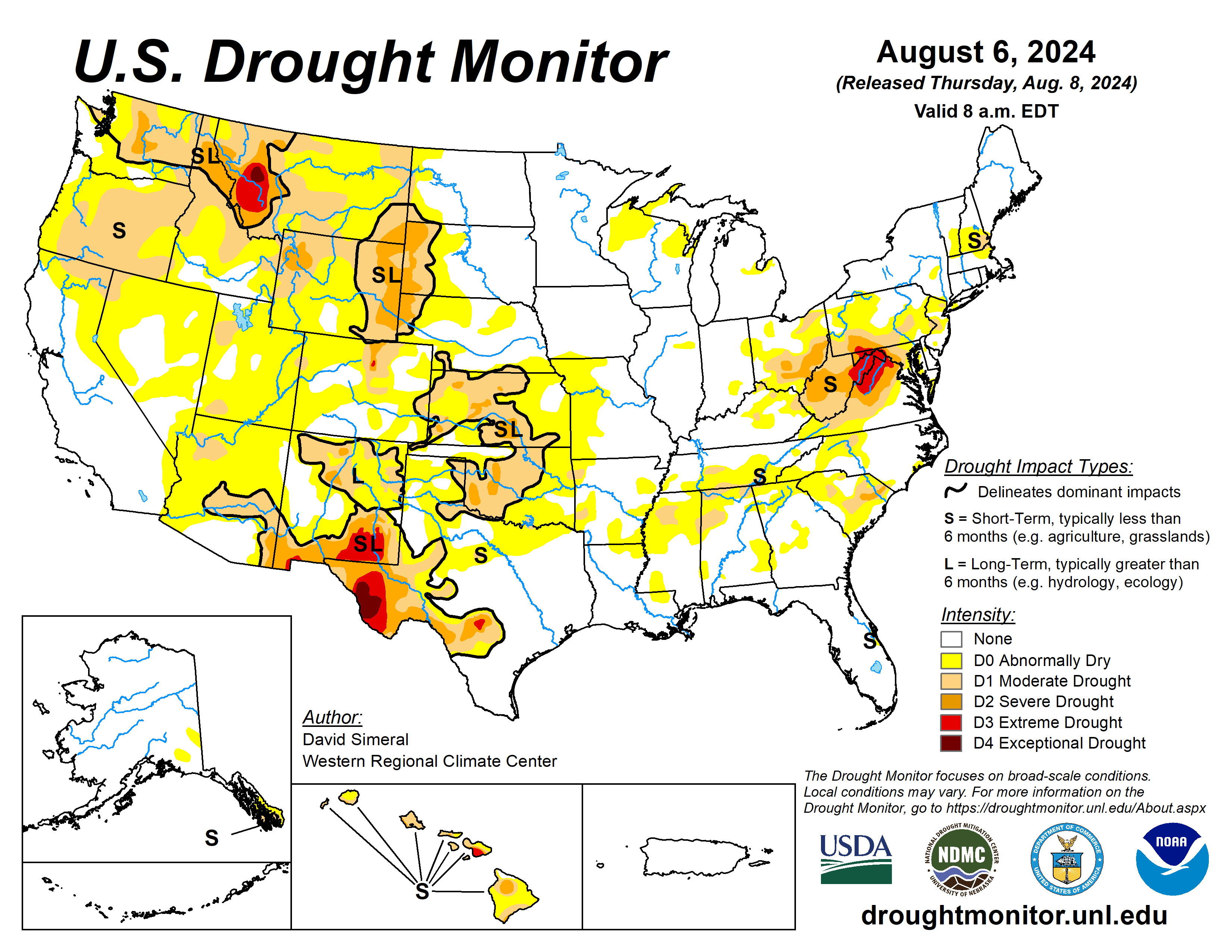
This U.S. Drought Monitor week saw widespread improvement in drought-related conditions on the map across areas of the Southeast, Mid-Atlantic, and in areas of the Midwest.
Elsewhere, hot and dry conditions prevailed in areas of the West, Plains, and the South during the past 14-to-30-day period, leading to the expansion and intensification of drought on this week’s map with particular concern over the developing flash drought situation in areas of the Plains states.
Hurricane Debby’s impact
In the Southeast, Hurricane Debby (Category 1) made landfall Monday morning in Florida’s Big Bend region bringing a powerful storm surge, strong winds, torrential rains, and severe flooding to much of Florida’s Gulf Coast region from southwest Florida to the north-central region. Rainfall accumulations ranged from 2 to 20+ inches across affected areas with the heaviest accumulations logged in the greater Sarasota area.
The impacts of Hurricane Debby, which weakened to a tropical storm shortly after making landfall, were also felt across the coastal zones and plains of Georgia and South Carolina with heavy rainfall (up to 15 inches according to radar estimates) and flooding. On the map, some drought-related improvements were made this week in the Carolinas in association with the remnant moisture from Hurricane Debby.
However, it is noteworthy that this week’s drought depiction is representative of rainfall that fell until the data cutoff at 8 a.m. ET on Tuesday and additional improvements are expected on next week’s map. Elsewhere, light-to-moderate rainfall accumulations (2 to 4 inches) were observed across areas of the Northeast, Midwest, and in isolated areas of the northern Plains. Some monsoon-related storm activity was observed in isolated areas of the Four Corners states and Nevada as well as some light shower activity in areas of Idaho and Montana.
The U.S. Drought Monitor is jointly produced by the National Drought Mitigation Center at the University of Nebraska-Lincoln, the U.S. Department of Agriculture and the National Oceanic Atmospheric Administration. (Map courtesy of NDMC.)
South
Across the region, dry conditions prevailed this week as well as above-normal temperatures with the greatest anomalies (+4 to 8 degrees Fahrenheit) observed in the Texas Panhandle and Trans-Pecos regions as well as in areas of southeastern Oklahoma, and southern portions of Louisiana and Mississippi.
Deterioration occurred in northern and western portions of Texas, eastern Oklahoma, southern Arkansas, and Mississippi, while near- to above-normal precipitation during the past 30-day period led to widespread improvements across Tennessee. In Oklahoma, the rapidly declining soil moisture and escalating fire danger are heightening concerns about widespread flash drought, according to the Oklahoma Climatological Survey.
In Texas, Water for Texas (Aug. 7) is reporting statewide reservoirs currently at 76.7% full with numerous reservoirs in the eastern part of the state in good condition, while many reservoirs in the western half of the state are experiencing below-normal levels. In terms of topsoil conditions across the region, the U.S. Department of Agriculture (week of Aug. 4) is reporting the statewide topsoil moisture rated by percent short to very short as follows: Arkansas 47%, Oklahoma 59%, and Texas 67%.
Midwest
Rainfall during the past 30 days has been well above normal across central Minnesota and southeastern Iowa. In terms of topsoil conditions across the Midwest, the USDA is reporting the statewide topsoil moisture rated by percent short to very short as follows: Minnesota 7%, Iowa 13%, and Missouri 19. For the week, average temperatures were above normal across the region with anomalies ranging from 2 to 8 degrees above normal with the greatest departures observed in Michigan’s Upper Peninsula.
High Plains
All states within the High Plains region saw degradations in response to a combination of factors including below-normal precipitation (past 30-60-day period), above-normal temperatures (+4 to 10 degrees during the past 14 days), high evaporative demand, and intensifying flash drought conditions in recent weeks.
Moreover, within the past 30 days, numerous agricultural impacts have been reported by extension agents as well as by local farmers and ranchers to the National Drought Mitigation Center’s Condition Monitoring Observer Reports system.
Impact reports include crop stress, critically low soil moisture, water hauling, and reduced forage, with the highest concentration of reports coming in from western portions of the Dakotas, western Nebraska, and eastern portions of Montana and Wyoming. According to the USDA statewide topsoil moisture rated by percent short to very short is as follows: Kansas 55%, Nebraska 49%, South Dakota 32%, Montana 68%, Wyoming 83%, and Colorado 58%.
West
The overall hot and dry pattern observed during the past 30-60-day period continued to desiccate many parts of the region leading to the addition of numerous areas of Abnormally Dry (D0) as well as expansion of areas of drought (primarily Moderate Drought D1) in the Pacific Northwest, California, Intermountain West, and the Southwest.
In terms of wildland fire potential for the remainder of August 2024, the National Interagency Fire Center’s Significant Wildland Fire Potential Outlook is forecasting above-normal fire potential across areas of Montana. Looking at statewide reservoir storage, reservoir storage with below-normal levels in Colorado, Montana, New Mexico, and Wyoming, according to the National Resources Conservation Service.
Looking ahead
The National Weather Service’s Weather Prediction Center 7-Day Quantitative Precipitation Forecast calls for rainfall ranging from 1 to 2 inches across areas of the Four Corners states as well as in the central Plains and southwestern portion of the Midwest. Elsewhere in the conterminous U.S., generally dry conditions are forecasted.
The Climate Prediction Center’s six- to 10-day outlook calls for a moderate-to-high probability of above-normal temperatures across much of the Four Corners states, much of the Plains states and the South. In terms of precipitation, there is a low-to-moderate probability of above-normal precipitation across the Intermountain West and areas of the central and northern Plains. Below-normal precipitation is expected across most of the South.
David Simeral is with the Western Regional Climate Center.


