Rain, snow fell in parts of Plains
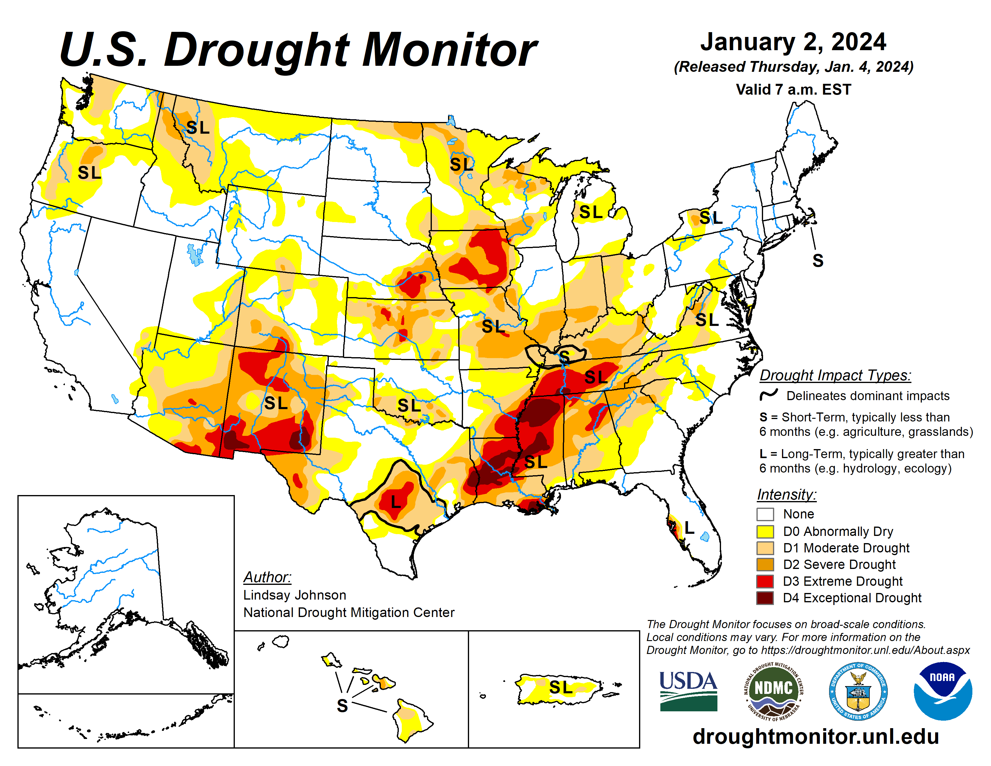
A large storm system brought rain and snow to the Pacific and Atlantic coasts along with rain and snow in the eastern High Plains and Midwest.
The South remained the same as last week, with small areas of deterioration from northeast Texas into southwestern Arkansas, and north and central Louisiana.
A small part of southeastern Louisiana and southern Mississippi saw minor improvements. The High Plains benefited from a rain and snow weather system that moved through the area before the new year. Northeastern Colorado into eastern Nebraska had some improvement.
Northern Colorado and Wyoming experienced deterioration without the benefit of the precipitation that fell further east and low snow water equivalent. The north-central Midwest had some improvements from the same storm that benefited the High Plains.
The West saw few improvements, except for New Mexico. Lack of precipitation and low SWE in higher elevations have left areas of Montana and Arizona worse off than last week.
The U.S. Drought Monitor is jointly produced by the National Drought Mitigation Center at the University of Nebraska-Lincoln, the U.S. Department of Agriculture and the National Oceanic Atmospheric Administration. (Map courtesy of NDMC.)
South
Little reprieve occurred across much of the South, with only 5% of normal precipitation falling. Western and central Texas remained unchanged, with a small improvement of Moderate Drought (D1) to Abnormally Dry (D0) conditions in the Panhandle.
Eastern Texas into western Louisiana and southwestern Arkansas saw 1-category degradations for all drought categories. Moderate Drought (D1) in northwest Louisiana extended west into eastern Texas and southwestern Arkansas.
Midwest
A weather system brought rain and snow into the Midwest, mainly in the north. Areas of central Illinois and both southeast and northeast Indiana saw improved conditions. Conditions in Minnesota, Iowa, Wisconsin and Michigan remain unchanged. Central Illinois and northeastern Indiana had improvement in Severe Drought (D2), Moderate Drought (D1), and Abnormally Dry (D0) conditions.
Missouri remained status quo except for Moderate Drought (D1) extending over the entire southern bootheel and slight improvement near St. Louis.
High Plains
A weather system bringing rain and snow moved through the High Plains midweek a week ago. Central and northern states experienced up to 400% of normal precipitation. Northeastern Colorado and eastern Colorado saw improvements in Exceptional (D4), Extreme (D3), and Severe (D2) drought conditions.
These improvements are a continuation of recent improvements. The weather system that brought improvements to much of the High Plains largely missed north-central Colorado. Conditions worsened, introducing abnormal dryness and degrading from Abnormally Dry (D0) to Moderate Drought (D1).
Northern Wyoming experienced similar conditions to Montana, leading to small Abnormally Dry (D0) and Moderate Drought (D1) expansions along the northern border with Montana.
West
Montana has not benefitted from the recent precipitation, causing small degradations along its border with Idaho, Wyoming and North Dakota. Precipitation continues to miss Arizona, mainly the north.
Over the past few months Abnormal Dry (D0) conditions expanded northward into southern Utah. New Mexico did see improvements in Extreme (D3), Severe (D2) and Moderate (D1) drought conditions in the interior northwest.
Looking ahead
Through Jan. 7, more heavy precipitation is expected for the central and northern Pacific coast, with some areas of higher elevation also seeing some moisture. The Gulf Coast and southern Atlantic regions are expected to see heavy precipitation. This centers around southern Louisiana, Mississippi and Alabama.
The National Weather Service Climate Prediction Center’s six- to 10-day outlook (valid Jan. 3 to 9) favors above-normal precipitation for most of the country. The highest probabilities are in the intermountain West, east of the Ohio and Mississippi River Valleys, Alaska and Hawaii.
Only southern Texas is expected to have below-normal precipitation. There is an increased probability of below-normal temperatures west of the Rockies, particularly in the southwest.
Lindsay Johnson is with the National Drought Mitigation Center.
Related Articles


