Moisture did find fields in the South
During the drought-monitoring period ending Nov. 14, precipitation was focused across a few geographic areas, including portions of the Northwest, South, and Great Lakes region.
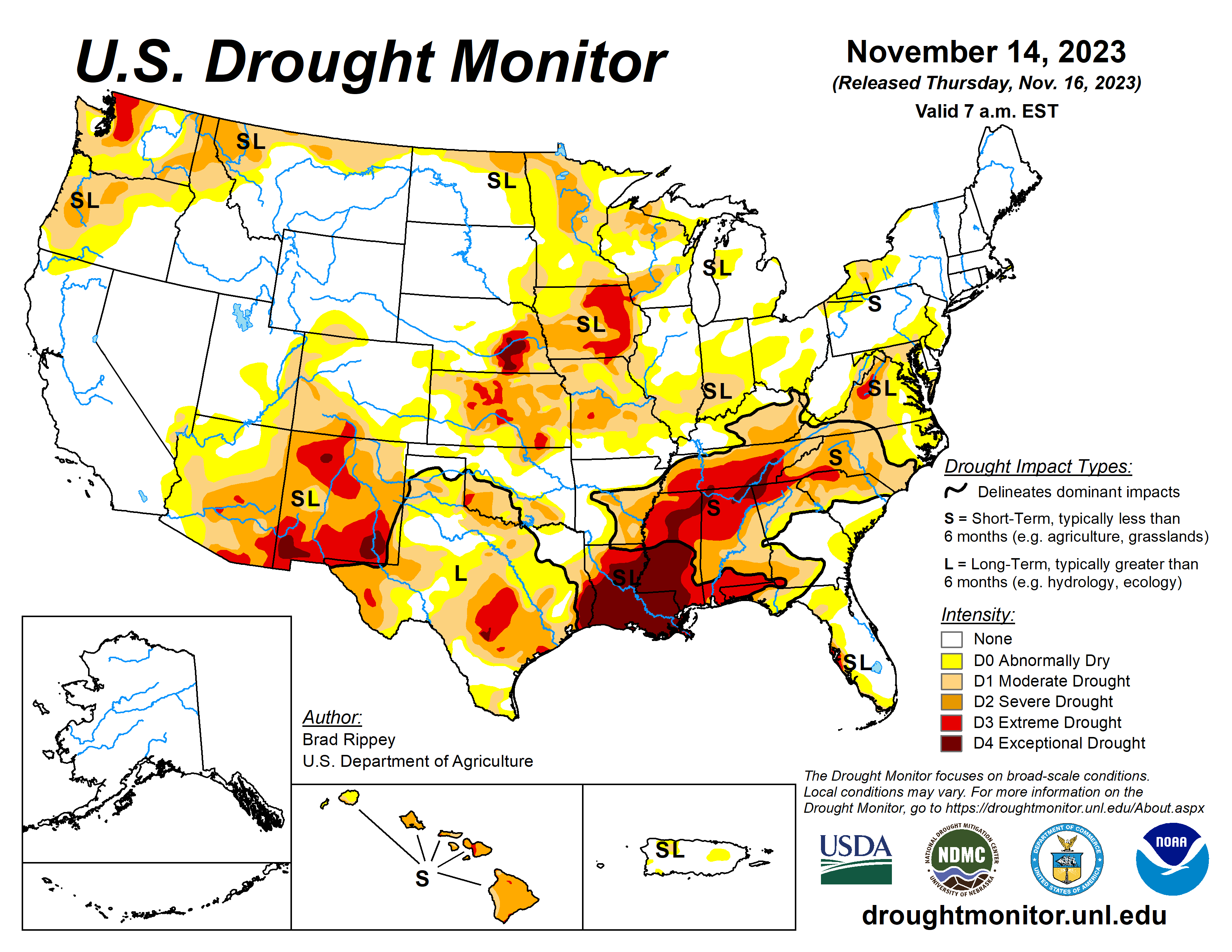
In places where precipitation fell, winter grains, cover crops, and rangeland and pastures generally benefited from the boost in topsoil moisture. The South has been contending with serious “flash drought” issues, including a rash of autumn wildfires. However, Southern rainfall coverage was spotty, with many areas receiving only light showers.
Following a nearly nationwide cold outbreak in late October and early November, warmth returned across most of the country, amplifying drought impacts in some of the driest areas.
The U.S. Drought Monitor is jointly produced by the National Drought Mitigation Center at the University of Nebraska-Lincoln, the U.S. Department of Agriculture and the National Oceanic Atmospheric Administration. The above map courtesy of NDMC.
South
Heavy rain in parts of Texas and along the Gulf Coast contrasted with mostly dry weather farther north and inland.
Accordingly, one- to locally two-category improvements in the drought depiction were noted in western, central, eastern, and southern Texas. Other areas experienced either no change or one-category drought deterioration. In fact, exceptional drought (D4) expanded further into the Tennessee Valley and environs. On Nov. 12, the U.S. Department of Agriculture rated topsoil moisture 88% very short to short in Louisiana, along with 84% in Mississippi. On the same date, pastures were rated 71% very poor to poor in Mississippi, along with 57% in Louisiana and 56% in Tennessee.
Midwest
Significant precipitation was limited to parts of the upper Great Lakes region, with the remainder of the Midwest experiencing mild, mostly dry weather. Those conditions were ideal for autumn fieldwork, with the U.S. soybean harvest 95% complete by Nov. 12.
In addition, 88% of the nation’s corn had been harvested on that date. However, soil moisture shortages remained a concern for some fall-sown crops, including winter wheat and cover crops. On Nov. 12, topsoil moisture was rated more than one-half very short to short in Iowa (58%) and Missouri (53%), according to USDA.
High Plains
Pockets of drought were mainly focused across eastern and southern sections of the region, with worsening conditions noted in parts of Kansas and neighboring states. According to USDA, topsoil moisture was rated more than one-half very short to short on Nov. 12 in Kanas (69%), Nebraska (61%), and Colorado (60%).
On the same date, 17% of the U.S. winter wheat crop was rated in very poor to poor condition, although state-level numbers were higher in Kansas (33% very poor to poor) and Nebraska (18%).
West
Aside from modest improvements in the Northwestern drought situation, there were few changes in the depiction. Despite the recent Northwestern precipitation, some interior agricultural areas remained dry, with topsoil moisture rated on Nov. 12 by USDA, 55% very short to short in Washington, along with 41% in Oregon. In addition, more than one-quarter (29%) of Oregon’s winter wheat was rated in very poor to poor condition on that date.
Farther south, New Mexico led the region on Nov. 12 with topsoil moisture rated 75% very short to short, despite patchy precipitation during the drought-monitoring period.
Looking ahead
Mostly dry weather will prevail during the next several days across the nation’s mid-section, including the Plains and upper Midwest. Farther south, showers will continue to shift eastward along and near the Gulf Coast, with the potential for late-week rain and gusty winds in parts of Florida.
Late in the weekend, some of the Pacific storm energy interacting with a surge of cold air arriving from western Canada should lead to an increase in rain and snow shower activity across parts of the western and central U.S., although precipitation will initially be light.
The National Weather Service’s 6- to 10-day outlook for Nov. 21 to 25 calls for the likelihood of below-normal temperatures east of the Rockies, while warmer-than-normal weather will prevail in the West. Meanwhile, below-normal precipitation in most areas west of the Mississippi River should contrast with wetter-than-normal weather in the East, and northern sections of the Rockies and High Plains.
Brad Rippey is with the U.S. Department of Agriculture.
Related Articles


