Much needed rain falls in key drought areas
During much of the drought-monitoring period ending November 21, mostly dry weather dominated the country, aside from some downpours in Florida and environs. By November 20-21, however, a storm system crossing the central and eastern U.S. slowed a rapid fieldwork pace but delivered much-needed rain in some of the nation’s key drought areas, including the South.
According to the U.S. Department of Agriculture, the U.S. corn harvest was 93% complete by November 19, ahead of the 5-year average of 91%. On the same date, harvest progress numbers for sorghum (96% complete), peanuts (92%), and cotton (77%) were also ahead of average.
Until the arrival of the late-period storm, precipitation was mostly confined to a few small areas—across the lower Southeast and from the Ohio Valley into the Northeast. However, parts of Florida’s peninsula received excessive rainfall (4 to 10 inches or more), as a non-tropical storm system grazed the region. Some precipitation also fell in the West, with many of the highest totals in portions of the Pacific Coast States. For the second week in a row, near- or above-normal temperatures prevailed nearly nationwide.
The U.S. Drought Monitor is jointly produced by the National Drought Mitigation Center at the University of Nebraska-Lincoln, the U.S. Department of Agriculture and the National Oceanic Atmospheric Administration. The above map courtesy of NDMC.
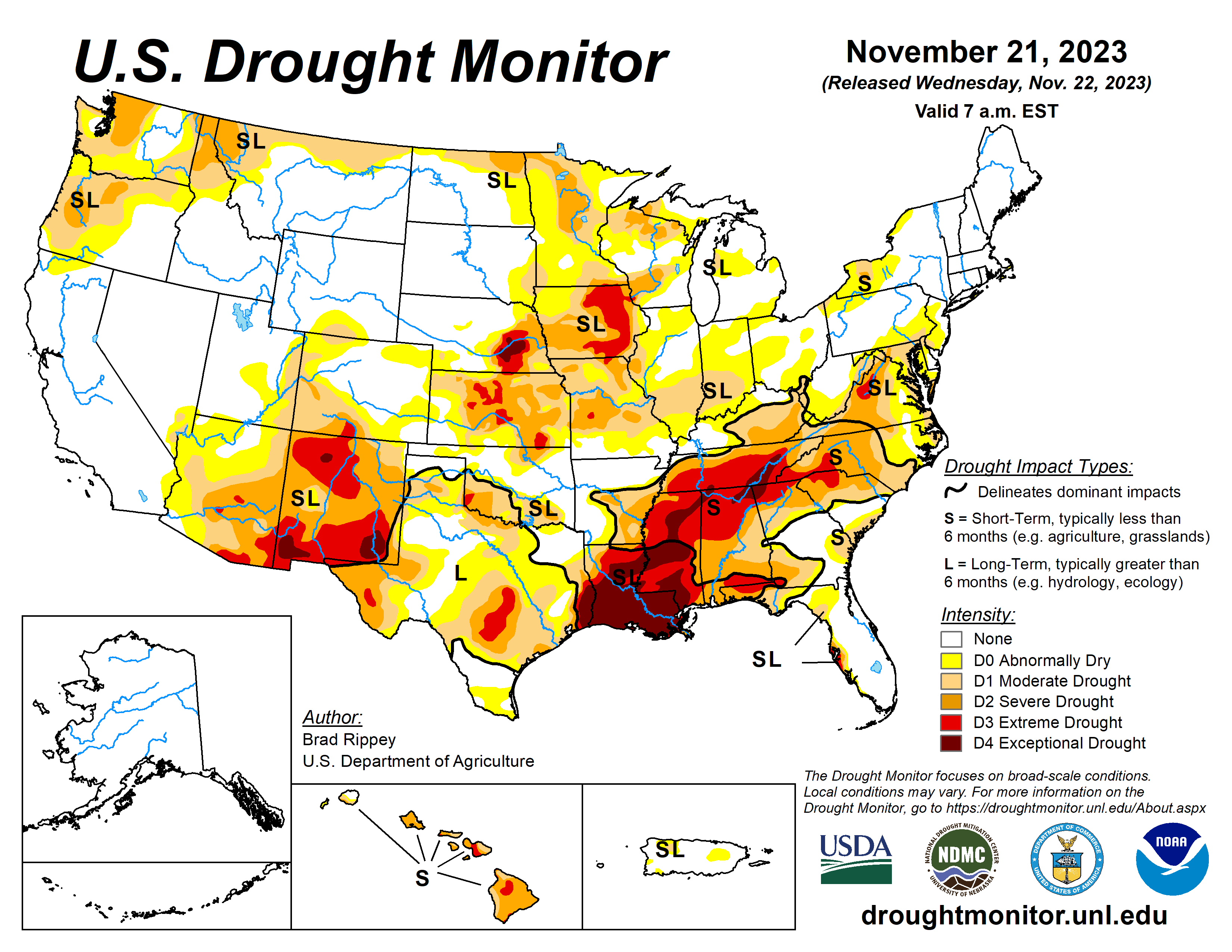
South
Precipitation fell in some areas both early and late in the drought-monitoring period. In Texas and environs, beneficial impacts from previous rainfall necessitated further improvement in the drought situation, in addition to last week’s changes. Farther east, heavy showers and locally severe thunderstorms overspread the Mississippi Delta and neighboring areas late in the monitoring period, with modest reductions in the coverage of exceptional drought (D4) in parts of Louisiana and Mississippi. On November 19, prior to the arrival of significant rainfall, pastures were rated at least 60% very poor to poor in Mississippi (69%), Tennessee (61%), and Louisiana (60%). On the same date, Mississippi led the region with topsoil moisture rated 82% very short to short, followed by Louisiana at 81% and Tennessee at 64%.
Midwest
Precipitation arriving late in the drought-monitoring period provided only limited relief in drought-affected areas. Some areas that missed most or all of the moisture turned a bit drier. On November 19, prior to the storminess, Iowa led the Midwest with topsoil moisture rated 69% very short to short, followed by Missouri at 64% and Kentucky at 56%.
High Plains
There were few changes in the drought depiction, despite some light to moderately heavy precipitation late in the monitoring period. By November 19, Kansas led the High Plains with topsoil moisture rated 68% very short to short, followed by Colorado at 64% and Nebraska at 55%. On that date, Kansas also led the U.S. with 32% of its winter wheat rated in very poor to poor condition, nearly twice the national value of 17%.
West
Generally light to locally moderately heavy rain and snow showers dotted the West. There were some additional improvements in the drought situation in the Northwest, and some slight further deterioration in the southern Rockies and environs. New Mexico led the West on November 19 with topsoil moisture rated 77% very short to short.
Looking Ahead
A low-pressure system crossing the Midwest will gradually weaken and drift eastward, while a trailing cold front will largely clear the Atlantic Seaboard by Wednesday. Additional rainfall across the eastern one-third of the U.S. could reach 1 to 3 inches, especially in the middle Atlantic States. Thanksgiving Day, November 23, will feature mild, dry weather across much of the country, although snow may blanket portions of the northern and central Rockies. The generally quiet pattern should last through the weekend after Thanksgiving, with most areas experiencing seasonable temperatures and minimal precipitation. In fact, negligible precipitation is expected during the next 5 days in much of the Mississippi Valley, as well as an area stretching from California to Texas.
The NWS 6- to 10-day outlook for November 27 – December 1 calls for the likelihood of near- or below-normal temperatures and precipitation across most of the country. Warmer-than-normal weather will be confined to southern Florida and areas along the Pacific Coast, as well as the nation’s norther tier from Washington to Montana. Meanwhile, wetter-than-normal conditions should be limited to the Deep South, from the southern half of Texas to the southern Atlantic Coast.
Brad Rippey is with the U.S. Department of Agriculture.
Related Articles


