Storms, cold temps blanket the High Plains
A stormy week across much of the eastern lower 48 states leading to widespread drought improvements from the Mississippi River Valley eastward to the Appalachians.
Behind the powerful storm system early this week, cold air plunged southward from Canada across the northern tier states, gradually spreading southward and eastward and overtaking most of the country east of the Rockies by the end of the week (Jan. 16).
Toward the end of the week, another storm system dropped wintry precipitation in a swath stretching from the Ozarks eastward to the Mid-Atlantic and Northeast. Across the western lower 48 states, precipitation was above average for the week. That lead to targeted improvements to drought areas across the Intermountain West, as snowpack continues to build for several locations.
Weekly precipitation and seasonal snowpack remain below normal across the Southwest and northern Rockies. That lead to some degradation of drought conditions.
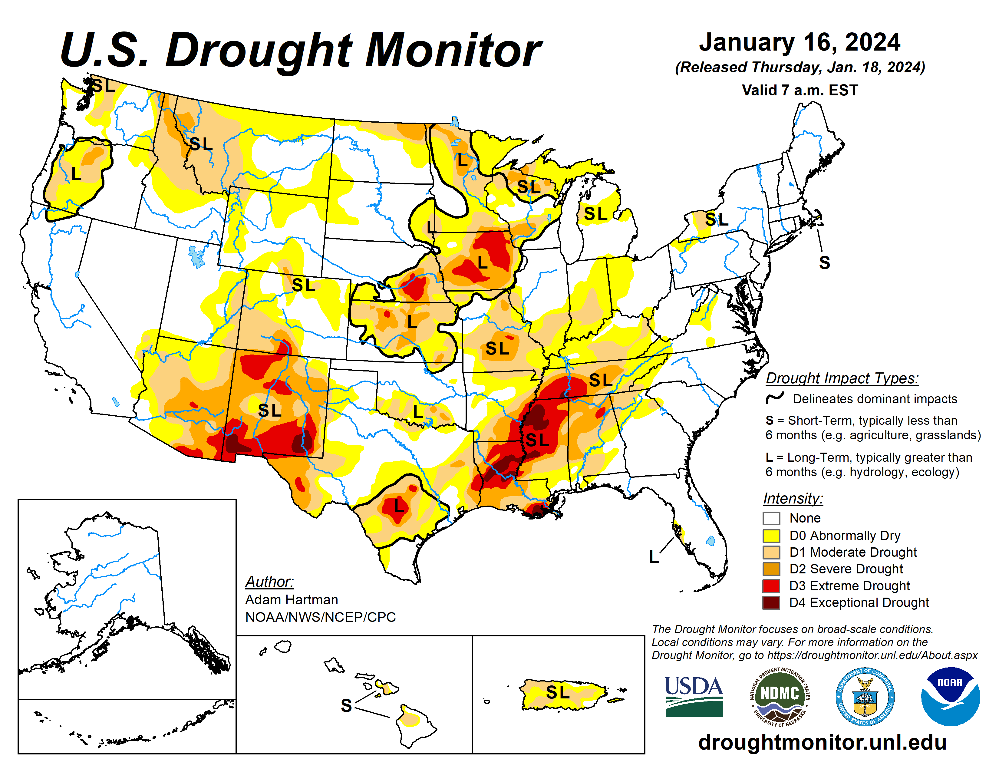
The U.S. Drought Monitor is jointly produced by the National Drought Mitigation Center at the University of Nebraska-Lincoln, the U.S. Department of Agriculture and the National Oceanic Atmospheric Administration. (Map courtesy of NDMC.)
South
Precipitation fell across portions of the Ozarks and Tennessee Valley, associated with a couple of storm systems leading up to the start of the weekend (Jan. 13). Many locations received in excess of 1 inch of rainfall. On Jan. 15-16, a winter storm dropped several inches of snowfall across many of these same locations.
Given the wetter than average conditions last week and another round of above average precipitation widespread improvement to drought conditions are warranted across portions of Arkansas and Tennessee.
In parts of southern Texas, some degradation to the drought depiction is warranted, where short-term precipitation deficits are starting to mount. No changes are warranted elsewhere across the region due to above average precipitation last week and cold temperatures spreading across the region.
Midwest
Precipitation well in excess of 200% of average for the week warrants widespread improvements to the drought depiction across the Ohio and Middle Mississippi Valleys and the southern Great Lakes.
Short-term drought indicators are showing marked improvements in recent weeks and soil moisture and hydrologic conditions (such as stream flows and groundwater) continue to improve for many locations, particularly across the Corn Belt.
High Plains
Storminess in recent weeks and frigid temperatures this week warrant no changes across much of the Central and Northern Plains. There are mixed improvements (Colorado Plateau) and degradations (High Plains along the Front Range) warranted this week.
Improvements to snowpack and short-term precipitation deficits this week warrant the improvements across the Colorado Plateau. A lack of seasonal snow cover has led to degradations across parts of the High Plains along the Front Range, due to topsoils being exposed and drying out.
West
Some degradation of drought conditions is warranted where below average precipitation was observed.
This is especially the case across western portions of Montana, where below average seasonal snow cover has left soils predominantly exposed, resulting in a slow decline in soil moisture over the past couple of months.
Looking ahead
During Jan. 18-22, a fast-moving storm system could bring some snowfall to portions of the Great Plains, Midwest, and Mid-Atlantic. Surface high pressure behind this system is expected to gradually bring more southerly flow across much of the eastern U.S.
As it moves eastward, leading to a moderation of the bitterly cold temperatures east of the Rockies, and some storminess across the south-central U.S., by Jan. 22. A series of storms is also forecast to impact the West Coast over the next five days.
The Climate Prediction Center’s six- to 10-day outlook (valid Jan. 22-26), favors enhanced chances of above average temperatures across the entirety of the lower 48 states. The highest chances (greater the 80%) centered over the Great Lakes.
Enhanced chances of above average precipitation is also favored across much of the lower 48 states from coast to coast. The highest chances (greater than 70%) across the south-central U.S. The exception is across the Northern Plains, where below average precipitation is favored.
Adam Hartman is with NOAA, NWS, NCEP, and CPC.
Related Articles


