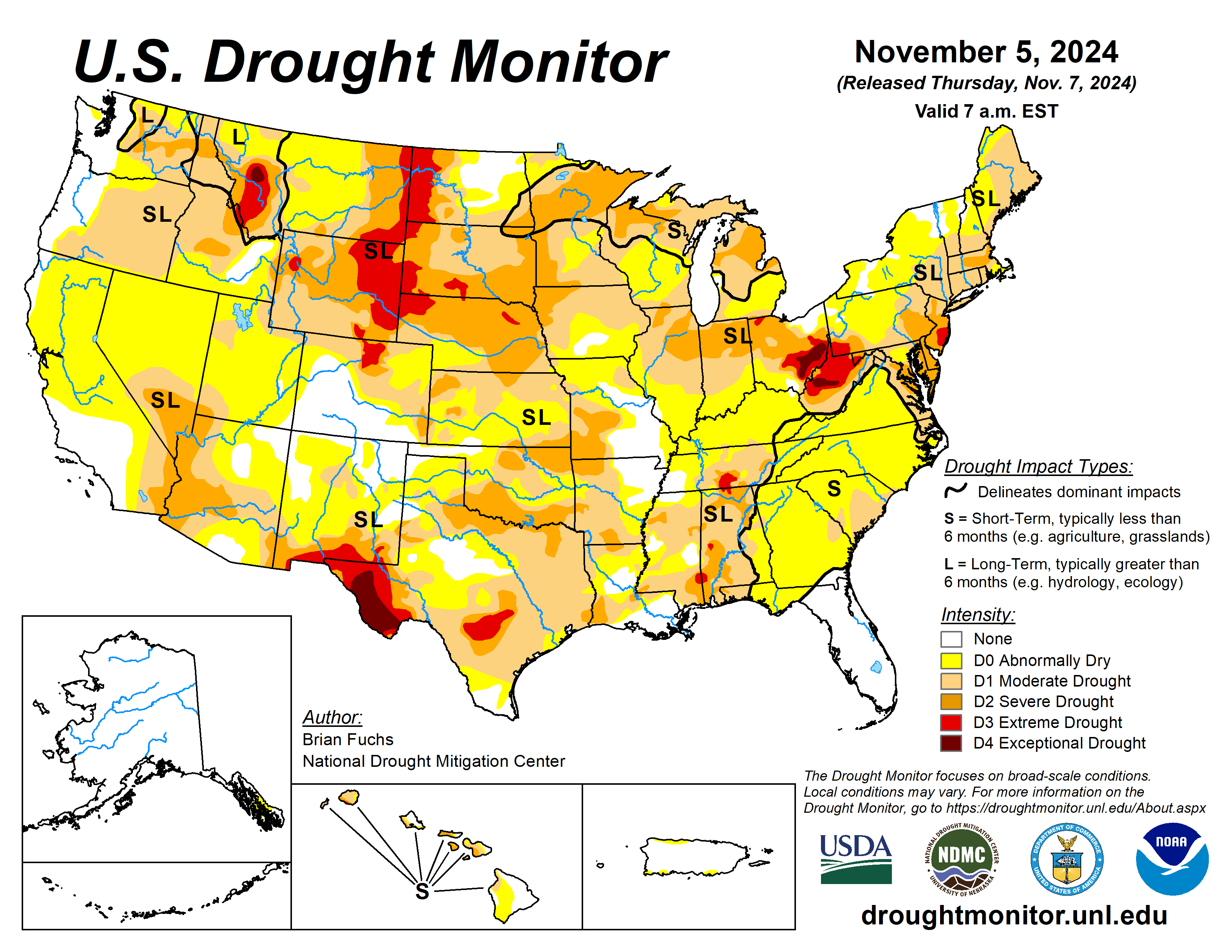
Over the past week, weather systems tracked over the southern Plains and into the Midwest, bringing much-needed precipitation.
Some areas of Arkansas and Missouri reported over 10 inches of rain for the week. The active pattern also continued over the Pacific Northwest, with the coastal areas and inland recording 2 to 4 inches of rain that helped to alleviate dryness. Temperatures over the West were below normal for the week, by as much as 6-9 degrees Fahrenheit in parts of Nevada, Utah and Arizona.
The rest of the country had warmer-than-normal temperatures, especially in Texas and into Louisiana, Mississippi, Arkansas and Alabama, where they were 9 to 12 degrees above normal. Many areas that received rain during the period had these rains come on the cusp of record-setting dryness in October, but many records were still set for areas that didn’t receive rain at the end of October and early November.
The U.S. Drought Monitor is jointly produced by the National Drought Mitigation Center at the University of Nebraska-Lincoln, the U.S. Department of Agriculture and the National Oceanic Atmospheric Administration. (Map courtesy of NDMC.)
South
Temperatures were 12 to 15 degrees above normal over much of the South, with areas of the Texas Panhandle into Oklahoma 6 to 9 degrees above normal. Much of Oklahoma and north Texas and Arkansas received significant precipitation, with widespread reports of 800% of normal rain for the week.
A full category improvement was made over much of Oklahoma and northern Texas and western Arkansas, with extreme drought removed from the region.
Midwest
Most of the Midwest was 9 to 12 degrees above normal for the week. The coolest temperatures were in the Upper Midwest, where it was only 3 to 6 degrees above normal. Widespread and significant precipitation arrived in many areas of the Midwest but many of the eastern areas were dry throughout the period.
Over 800% of normal rain was recorded in much of southern Missouri and central Iowa. There was a wide swath of southern Missouri into northern Arkansas where CoCoRaHS observers reported 10+ inches of rain for the current Drought Monitor period. The rains brought widespread improvements to drought, with full-category improvements through much of Missouri and into most of Iowa. Drought conditions improved by a full intensity level and some drought was removed completely.
Drought eased in central Minnesota and southern Missouri had multiple-category improvements. Moderate drought expanded slightly in western Minnesota.
High Plains
Significant rains fell over much of Kansas, into southeast Nebraska and southeast Colorado. Rain and snow fell from portions of eastern Colorado into Wyoming and into the Dakotas too, reversing the trend of very dry conditions.
Not all areas were as fortunate, with northeast Colorado, western Nebraska, eastern and southwest South Dakota and northwest North Dakota remaining dry. The region was split, with temperatures in the western areas 3 to 6 degrees below normal, and temperatures 9 to 12 degrees above normal in much of eastern Nebraska and eastern Kansas.
Much of eastern Kansas saw a full category of improvement, with extreme drought being removed from the southeast. Severe drought was removed from far southeast Nebraska. In western North Dakota and in eastern Montana, severe and extreme drought expanded slightly.
Some improvements were made to abnormally dry conditions over central to southern Colorado and to moderate drought over northeast Colorado. Moderate drought expanded across central South Dakota.
West
Precipitation was scattered over much of the West, with the greatest rain over the Pacific Northwest, where 200% of normal rain was recorded for the week in much of Oregon and Washington. Cooler-than-normal temperatures dominated the region with many areas of Nevada, Utah, and Arizona and into western Wyoming were 6 to 9 degrees below normal for the week.
Dryness continued to dominate much of Montana with abnormally dry conditions expanding to fill the rest of the state and moderate and severe drought expanding in the west. Some improvements were made over eastern New Mexico as a result of the continued wetter conditions.
Looking ahead
Over the next five to seven days, it is anticipated that the wet pattern will continue over much of the southern Plains and into the South, Southeast, and Midwest. Greatest precipitation is anticipated over the southern Plains, where 3 or more inches of rain is anticipated. Much of the West will remain dry.
Temperatures will remain cooler than normal over much of the West with departures of 10 to 12 degrees below normal over northern New Mexico and southern Colorado. Much of the eastern half of the country will be warmer than normal, while areas of the Midwest and South are anticipated to be 10 to 12 degrees below normal.
Hurricane Rafael has formed in the Gulf of Mexico and is projected to track westward. It may not make landfall until the middle of next week but could impact the dryness over the South and southern Plains depending on its path.
The 6- to 10-day outlooks show that the probability of above-normal temperatures will be greatest over the eastern half of the United States, especially over the Midwest and into the Southeast. Chances of cooler-than-normal temperatures are greatest over the West. Most of the country has a good chance of recording above-normal precipitation during the period, especially over the Pacific Northwest.
Brian Fuchs is with the National Drought Mitigation Center.


