Frontal and thunderstorm activity provided moderate to heavy rain (at least 0.5-inch) over northern, eastern, and central portions of the contiguous United States this past week. According to the June 5 U.S. Drought Monitor released June 7, weakness in the mid-tropospheric subtropical ridge over the Gulf of Mexico and southeastern states contributed to the influx of subtropical moisture across this region. Over the weekend, a cold front moved into the mid-Atlantic area and stalled, providing a lifting mechanism for the inflowing moisture. This resulted in heavy rain (generally 2 to 6 inches, locally greater) across much of Virginia, Maryland, eastern West Virginia, and southern Pennsylvania. Temperatures were near to above average across practically the entire contiguous U.S., with the greatest departures (6 to 12 degrees F above average, locally greater) for a large portion of the southern Great Plains, the Mississippi Valley, the Dakotas, the Great Lakes region, and the Ohio Valley.
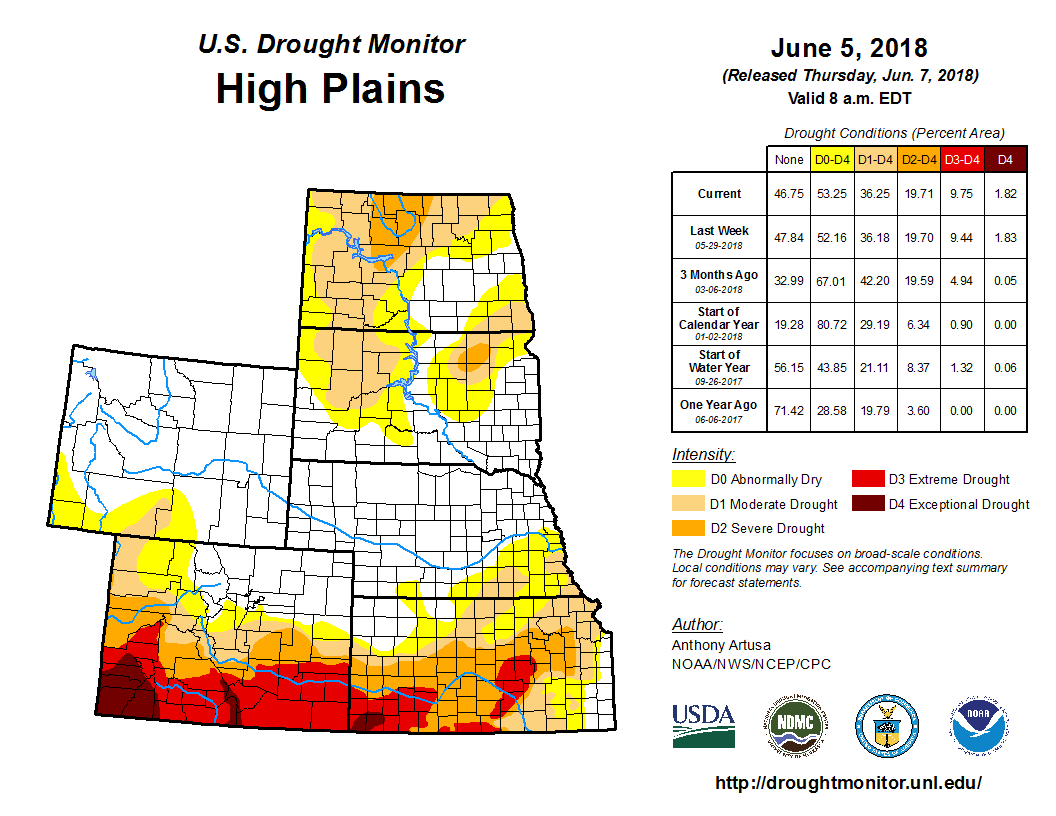
Heavy rain (2 to 6 inches, locally greater) fell over portions of North Dakota this week, with the highest amounts over the northwest part of the state. Much of the heaviest rain actually fell north of the Canadian border in extreme southeastern Saskatchewan. Slight alterations (both improvement and deterioration) were rendered to the depiction in western, north-central, and southeastern North Dakota, based in part on the 1-month EDDI, which takes into account evaporative demand. Both improvements and degradations were also made to the South Dakota depiction, which received much less rain this week than its northern counterpart. For example, Aberdeen reported only 0.52-inch of rain in May (2.59 inches below normal), making it the seventh driest on record. An area of severe drought (D2) was introduced to northeastern South Dakota, based on 60-day precipitation deficits, 30-day and 60-day SPI, recent warm temperatures, and increased water demand through evapotranspiration. A spectacular dust storm, attended by 50 to 80 mph winds, blew through this region (Hand and Faulk Counties) on June 1. In southeastern Colorado, a one-category degradation was made to the depiction in Kiowa County. Decent soil moisture from the wet summer and fall of 2017 is now gone, due to the recent hot, dry weather. This, in turn, has taken its toll on crops. Although welcome rains fell across eastern Nebraska this week, it was decided not to make any changes to the state depiction until more information is at hand next week.