The National Oceanic and Atmospheric Administration, along with climate partners, presented a monthly climate and drought summary and outlook Oct. 17. The North Central region includes Colorado, Illinois, Indiana, Iowa, Kansas, Kentucky, Minnesota, Missouri, Montana, Nebraska, North Dakota, Ohio, South Dakota, Wisconsin and Wyoming.
Laura Edwards, South Dakota state climatologist, gave the climate segment of the webinar and said she’s in the epicenter of the excessive wetness of her state. Across much of the region, snow was dumped Oct. 11 to 13, and some parts of North Dakota received more than 3 feet of snowfall.
“It’s been two years in a row that we’ve had snow essentially, Oct. 10 to 18, around that time in this region,” she said.
For the month of September, Edwards said, the maps showing county levels of temperatures gives a true picture of how warm it was. Some areas had record levels of heat, some set records for the warmest readings in 125 years of recordings.
“So really unusually warm compared to what we’ve seen much of the year,” she said. “We’ve had a lot of cooler, moderate temperatures. A lot of average temperatures actually were driven by high minimum temperatures, not so much the high day time temperatures in September.”
When she looks at the growing season, the north central states—Montana, Wisconsin, and down in to Kansas were closer to average.
The eastern part of the region was on the warmer side, while the northern and western states were more moderate for the growing season so far.
As climatologist, she’s heard a number of comments throughout the region where one part is wet and another is dry. Her county maps show just how rapidly some of the changes occur.
“Maps like these really tell that story of how tight that gradient is or how rapid those transitions are just on a statewide basis, from north to south in this case,” she said.
Conditions vary widely
Dryness and drought concerns have been raised in the eastern part of the North Central region, while excess moisture concerns are happening in others.
“Looking at growing season so far—April to September—my state, South Dakota sticks out kind of as a sore thumb with new record wettest April through September on records,” Edwards said. “We’re on par, less than an inch away from our record wettest year of January through December, and we still have about two and a half months left in the year.”
Edwards believes South Dakota will set a new record for precipitation in 2019.
“Certainly that has been one of the key stories of the season so far,” she said.
Within the last 30 days, temperature departures from normal showed cooler temps in western, northwestern part of this region. Warmer temperatures compared to average from Missouri to Ohio, and over Kentucky as well, with some much above warmer temperatures of eight to 10 degrees or so over the last 30 days.
“So really the exceptional warmth over the last month has been very noted,” Edwards said.
Soil moisture levels reflect very wet conditions.
“This isn’t probably a new story for many of us are seeing,” she said. “Above average soil moisture as well, which is driving a lot of the flood concerns and area’s rivers and streams as any moisture that we get as rainfall. There’s just no capacity or very little capacity in the soil now to take up that moisture so we get high runoff generated with relatively low precipitation.”
Going forward into the winter season, the excess soil moisture levels are concerning, as it all could freeze in place.
“If you imagine a sponge, totally soaked up with water and you put in freezer. Try to pour water on it again after it’s frozen and it just runs off,” Edwards said. “I think this is one of the concerns as we get into the agricultural stories for the winter into the spring season as well given these current soil moisture conditions going into the cold season.”
Record rainfall for some, drought conditions for others
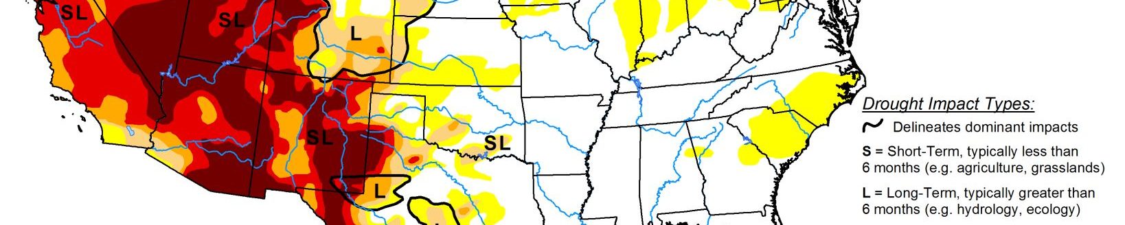
There’s also areas facing dry conditions and some areas in Colorado have reached the moderate to severe levels in the southwest part of the state. Western Kansas is becoming concerning as well. The Ohio River Basin has been struggling with drought conditions too.
Edwards gave a three-month outlook for December through February, and said there’s equal chances of warmer, cooler or near average conditions for much of the region.
“It appears with the southern (area) and kind of all around us—leaning towards warmer for that December through February period,” she said. “A lot of the models are starting to hone in and forecasters are starting to hone in on wetter than average favored across the northern tier states from Montana to the Great Lakes.”
Agricultural aspect
Brad Rippey of the U.S. Department of Agriculture and an author of the U.S. Drought Monitor shared the highlights and low lights of the 2019 crop season.
“The Midwestern planting was severely delayed by wetness with some of those delays extending across the northern plains and extending down toward the central plains,” Rippey said. “Of course, on top of weather, we had market factors that had a big role in how things were planted this year.”
Low commodity prices and the trade war favored producers planting corn instead of soybeans. Typically in a wet year, soybeans often see a gain in acreage because they can be planted a little later into the season and still make a crop.
“That did not happen very much this year, in part because there was so much storage on farm due to the fact that China was not buying soybeans,” Rippey said. “So that really upended the entire planting season as well.”
According to Rippey, U.S. corn production as of Oct. 1 estimates show the crop down 4.4% despite very little change in area harvested. But those totals didn’t include recent snowstorms or cold outbreaks, he said.
“The yield is down eight bushels an acre nationally, 4.5% down from last year,” Rippey said. “The big bump was in soybean production. Down 20% from last year. Much of that decline is attributable to the decrease in harvested acres or anticipated harvested acres, but some 7.3% was due to a yield decline fairly sharp from last year.”
As of the most recent USDA report, just over half of the U.S. corn and soybeans rated good to excellent compared to 68% and 66%, respectively at the same time a year ago.
The mid-October snowstorm and blizzard in some areas was trailed by a significant cold outbreak, which essentially ended the growing season. Rippey said in many areas from the upper Mississippi valley westward, temperatures dropped to 28 degrees or lower.
“That put the brakes on any further crop development for corn and soybeans,” he said.
The big story though is the excess moisture or topsoil moisture that’s being observed, like Edwards mentioned. From the northern states in the region, Montana and Michigan and southward towards Iowa, there are ratings from USDA of at least 30% surplus to a national high of 62% in North Dakota as of Oct. 13.
“And again, whether that gets frozen into the system or partially runs off will have some impacts on possible spring planting issues as we move forward, especially as Laura mentioned in those outlooks,” Rippey said. “If we maintain a snowy or wet pattern all the way through the winter months.”
On the flipside, Rippey said there’s very little to talk about in terms of short and very short numbers as far as soil moisture goes in the region. Both Rippey and Edwards were not concerned at this time about the developing drought in southwest Kansas.
“We’re still too early to say that there’s any kind of an issue,” she said.
Kylene Scott can be reached at 620-227-1804 or [email protected].
Related Articles