According to the June 25 U.S. Drought Monitor released June 28, a couple of strong upper-level low pressure systems moving in the jet stream flow slowly crossed the northern half of the contiguous U.S. during this U.S. Drought Monitor week. The lows dragged surface lows and frontal systems with them. Supplied with abundant Gulf of Mexico moisture, these systems generated numerous mesoscale thunderstorm complexes which dumped heavy rain across parts of the Plains to Midwest and Mid-Atlantic coast. The clouds and rain associated with the lows and fronts also brought cooler-than-normal temperatures to the central Plains to Northeast. A moist low pressure system at the beginning of the week dumped heavy rains along the Texas Gulf coast. Contraction of drought and abnormally dry areas occurred in the Plains and Texas Gulf coast where precipitation was above normal for the week. However, these lows tracked within a larger-scale upper-level ridge system. Drier-than-normal weather dominated much of the West, large parts of Texas and the Southeast States, and from the western Great Lakes to most of the Northeast, with drought and abnormal dryness expanding in parts of the West, South, and Northeast. The week was warmer than normal across much of the West, along the northern tier states, much of Texas, and most of the Southeast.
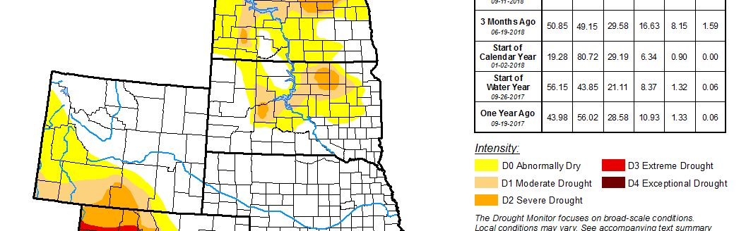
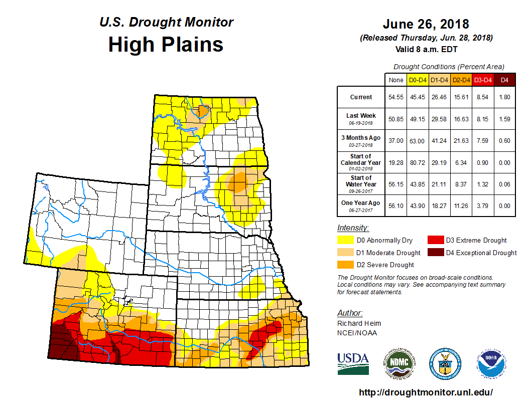
Several rounds of heavy thunderstorms moved along frontal boundaries on multiple days in the High Plains states. Two inches or more of rain was measured across the western two-thirds of Kansas, the eastern half of Nebraska, and in parts of South Dakota, Montana, and Wyoming, with 5 inches or more indicated for southwestern Kansas, eastern Nebraska, and southeast South Dakota. The week was drier than normal for other parts of the High Plains, with western Colorado to southwestern Wyoming receiving little to no precipitation. The rains resulted in pullback of D0-D2 in Kansas, with some 2-category improvements in southwest Kansas, contraction of D0-D1 in Nebraska, and trimming of D0 in South Dakota. With the heavy rains missing eastern Kansas, the week ended drier than normal there, further increasing precipitation deficits for the last 1 to 3 months and, in northeast Kansas, out to 9 months, so D0-D2 were expanded in eastern Kansas. Some of the heavier rains crossed from Kansas into Colorado, but just barely. D2-D3 were pulled back a bit in far eastern Colorado, but the dry conditions further west resulted in D2-D3 expanding in central and west-central Colorado, and D4 expanding in west-central Colorado. June 25 USDA statistics indicated 53 percent of the pastures and rangeland in Colorado were in poor to very poor condition.