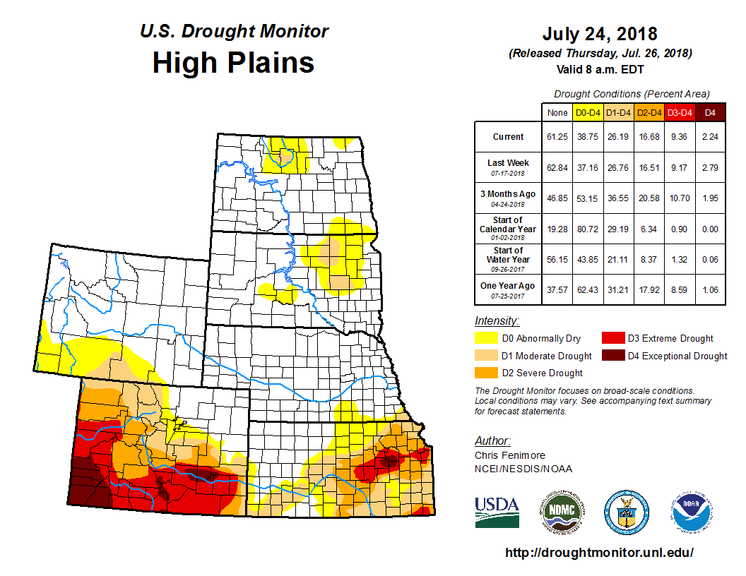
According to the July 24 U.S. Drought Monitor released July 26, during the period covering July 17 to 24, precipitation fell across a vast majority of the East, the heaviest of which flooded parts of Maryland, including the Washington, D.C., area. Heavy rains also fell in parts of Florida, Kentucky and South Carolina. In the central U.S., moderate precipitation fell in parts of the High Plains while lighter rains provided little to no relief in parts of Kansas. The drought-stricken areas of Oklahoma and Texas saw little to no precipitation and triple digit temperatures, exacerbating drought conditions.
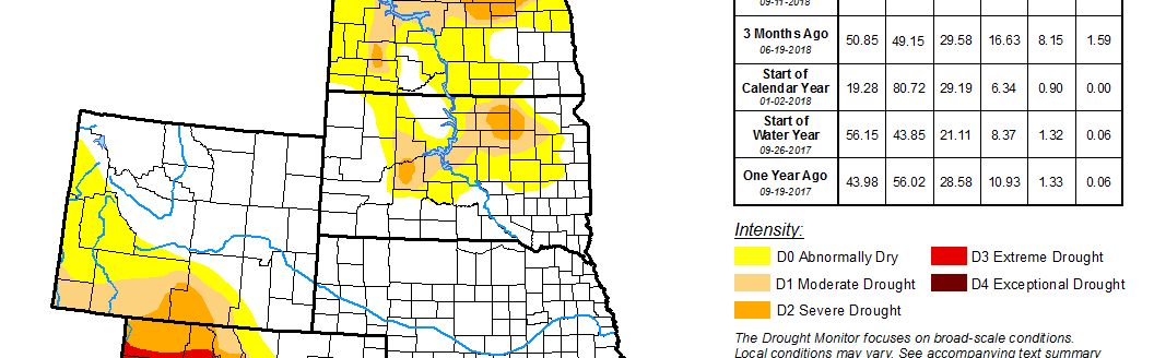
Precipitation across the High Plains region was scattered during the USDM week. The heaviest amount, generally in the range of 2 to 4 inches, fell in the eastern Dakotas and parts of Nebraska. Short- and long-term effects of drought/dryness remain along the Canadian/North Dakota border and northeast South Dakota. Recent rains in South Dakota contracted drought along the southern portion of the depiction, but expanded the abnormal dryness (D0) in the western part. Abnormal dryness was introduced in south central South Dakota. In Nebraska, drought/dryness began to creep back into the southeast part of the state where 30-day precipitation departures were apparent. Drought/dryness worsened in Kansas during the period, especially in the eastern half of the state where precipitation deficits have grown. Year-to-date precipitation percent of normal values were 25 to 50 percent across parts of east central Kansas. Exceptional drought (D4) was slightly expanded in this area and the two areas of extreme drought (D3) were connected. Drought conditions remained unchanged for the most part In Colorado. The lone exception was a slight contraction of exceptional drought in the southeast where heavy rains recently fell. Severe drought was expanded slightly in the north central part of Colorado.
The Midwest experienced a mixture of both above- and below-normal precipitation amounts during the USDM week. In eastern Kentucky and Tennessee and along the border of Ohio and Indiana, precipitation amounts were the highest. As much as 5 inches of rain fell in those areas. Farther west, dryness prevailed. Little to no rain was measured across much of Illinois, eastern Missouri and western Iowa. Precipitation totals in those areas were 25-50 percent below normal for the 30-day period. The USDA reported that topsoil conditions were 77 percent short to very short in Missouri while subsoil conditions were 72 percent short to very short. Farmers in Missouri are having to bail the corn crops since little to no ear development is widespread. In Michigan, topsoil was rated at 68 percent short to very short and subsoil conditions were 72 percent short to very short. Local reports indicated that soybeans in parts of Michigan were less than 2 feet high and the leaves were flipped and showing their undersides. USDA reported that soybean conditions were 20 percent poor to very poor across the entire state. D0 drought was expanded to cover most of Lower Michigan and D1 was expanded slightly in eastern Michigan and introduced in southern Michigan. Abnormal dryness was also introduced in central Wisconsin and southeast Illinois, and expanded in parts of northern Minnesota.