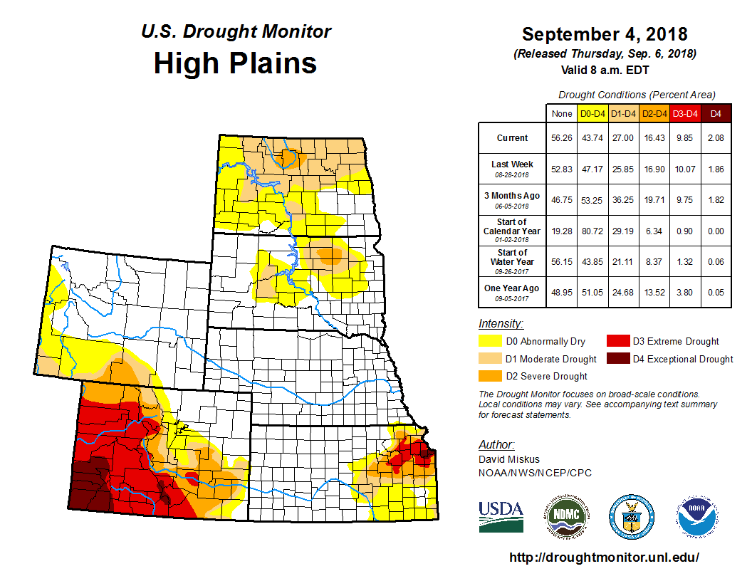
According to the U.S. Drought Monitor for Sept. 4 released Sept. 6, stalled fronts over the nation’s mid-section became a focal point for widespread heavy showers and thunderstorms, especially from the central Great Plains northeastward into the western Great Lakes region. Parts of Kansas, Nebraska, Missouri, Iowa, Illinois, Wisconsin, and Michigan saw over 5 inches of rain for the week, with locally 10 to 15 inches of rain in southern Wisconsin. Needless to say, major improvements were made in the Midwest. Tropical showers also occurred along the Gulf Coast, and later in the week Tropical Storm Gordon formed in the eastern Gulf and tracked northwestward toward Mississippi. Scattered showers also fell on parts of the Four Corner Region, the northern Plains, upper Midwest, mid-Atlantic, and western New England. Little or no rain was observed in the West, northern and central Rockies, north-central High Plains, across sections of the interior Southeast, eastern Corn Belt, and coastal New England.
Rainfall amounts were either lacking or light across most of the High Plains, except for very heavy rains (2 to 6 inches, locally higher) in eastern Kansas and southeastern Nebraska (associated with the copious rains in the Midwest), and light to moderate (0.5 to 2 inches) in parts of the Dakotas and southeastern Colorado. In Kansas and southeastern Nebraska, 2 to 8 inches of rain caused a 1-2 category drought improvement across southeastern Nebraska and northeastern and southeastern Kansas, while 1 to 3 inches of rain in far western Kansas was good for a 1-category reduction. Unfortunately, the core D3-D4 drought area in east-central Kansas received much lower totals (less than an inch), and little or no improvements were made there. Farther north, drier weather this week and out to the last 60 days has slowly increased short-term deficits, resulting in some minor deterioration in northeastern Montana, northern North Dakota, central and northeastern South Dakota. While continuing rains eased drought in southeastern Colorado into northeastern New Mexico, worsening conditions in west-central Colorado slightly expanded the D4 there. Monsoonal showers were widely scattered across eastern Arizona and most of New Mexico, but most areas were unchanged.


