The upper-level circulation during this U.S. Drought Monitor week consisted of a trough over the eastern contiguous U.S. and a ridge over the west coast, according to the U.S. Drought Monitor for Nov. 20 released Nov. 21. The trough, with its northwesterly flow, funneled cold and dry Canadian air masses into the central and eastern CONUS. Below-normal temperatures spread across most of the CONUS, with weekly temperature departures more than 15 degrees below normal across parts of the central Plains to Midwest. The cold fronts were fed by Gulf of Mexico and Atlantic moisture when they reached the southern and eastern coasts. Low pressure systems tracked along the fronts to produce an inch of precipitation along the Gulf Coast, and 1 to locally over 2 inches across much of the country from the Tennessee and Ohio valleys to East Coast. The precipitation in the East was enhanced by a slow-moving upper-level low early in the week. The western ridge deflected Pacific storm systems away from the western CONUS and into southern Canada, making for a very dry week across much of the West with no precipitation recorded. The ridge also enhanced high surface pressure over the Great Basin, which produced strong Santa Ana winds that fanned devastating wildfires over California. As they tracked around the top of the ridge, some of the Pacific systems combined with the Canadian cold fronts to generate areas of precipitation in Washington, the northern and central Rockies, and a few areas in the northern Plains. Other than these few areas of precipitation, the Plains to Mississippi Valley were mostly dry with well less than half an inch of precipitation falling. Drought and abnormal dryness contracted in parts of Montana, North Dakota, and the Southwest. It expanded in a few areas and contracted in others in the Southeast. Moderate or severe drought expanded across a large part of California into Nevada, and in parts of the Pacific Northwest.
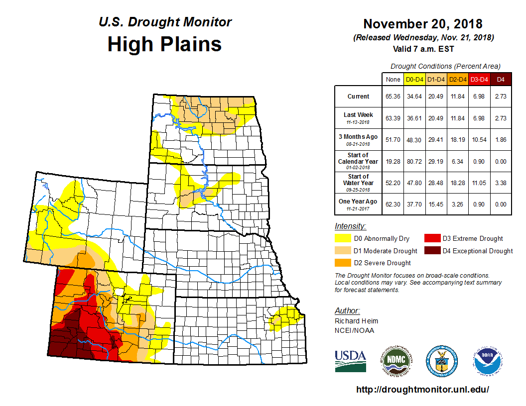
The northern to central Plains were cold this week and most areas were dry. A swath of above-normal precipitation, which amounted to 0.5-1.0 inch, stretched from northeast Montana to northeast South Dakota, with other patches in Wyoming and southeast Nebraska. D0 contracted in north central Montana and southwest North Dakota where precipitation was above normal this week and above normal (wet) for most of the time scales for the last 2 years. According to Nov. 18 reports from the USDA, topsoil moisture was short or very short across 26 percent of North Dakota and 39 percent of Wyoming. D0 contracted in Colorado, basically over Boulder County, which was a foot of snow above average to start the snow season, and not showing any long-term precipitation deficits.