Kansas wheat farmers will potentially see and feel effects from the El Niño weather pattern expected to move into the United States over the next six months. Although the El Niño is expected to be fairly weak, NOAA’s Climate Prediction Center has predicted that most of the country is going to be slightly warmer than normal, with a much milder winter in store. With a milder winter, wheat has a greater chance at breaking dormancy earlier.
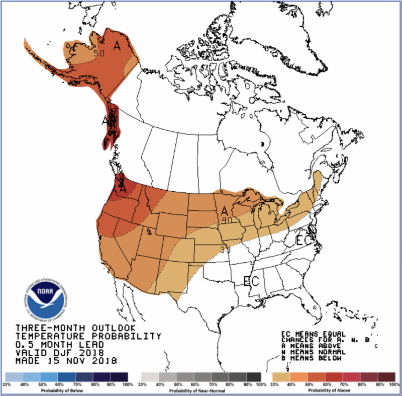
Mary Knapp, assistant climatologist with Kansas State University, says NOAA’s CPC just released their three-month outlook for November, December and January. This looks at the average condition over the three-month period and how it compares to what you normally see. Knapp says the outlook is calling for warmer than normal temperatures and equal chances for wetter or drier than normal conditions.
"They are calling for wetter than normal along the desert southwest and along the gulf coast region. That is very typical when you have an El Niño, which is warmer than normal waters in the Pacific," says Knapp, "Those warmer waters in the Pacific influence the jet stream positioning and the tracks that storms systems have coming across the U.S."
Knapp says that a weather system like this brings Pacific moisture along the southern parts of the United States with parts that can make their way up into Kansas.
Some things they look for to determine the weather pattern include a four-corner storm, which is where low pressure comes from the desert southwest and moves across the southern plains into the northeast portion of the country. The track that a four-corner storm takes, either across Texas or Oklahoma, will ultimately influence how much snow or moisture Kansas will receive, since it is on the north end.
When referring to a four-corners storms, climatologists look at the junction of Utah, Colorado, Arizona and New Mexico. Knapp says that when a system comes out of this area, it typically brings Gulf moisture in advance, which flows into the plains, making temperatures more moderate with lows in the 20s. A storm like this is milder, has more moisture and has a better chance at producing snow.
If a four-corners storm runs through Oklahoma, Kansas will have a better chance to get snow cover, leaving the wheat crop more insulated and hopefully dormant.
The Madden-Julian oscillation is also factor that can influence Kansas beyond the El Niño, which causes a difference in where storms originate in the Pacific and how they track across the United States. The phase it is in controls how active it is and how many storm systems come across.
Knapp says the North Atlantic oscillation is another factor which looks at the pressure gradient across the Arctic. When it’s set in a certain phase, Kansas gets more of those northern storms tracking into the plains.
Looking a little bit further into the year, Knapp says they are calling for warmer temperatures, still, and equal chances on the moisture, which could have a negative effect on the wheat. Knapp says that milder temperatures don’t necessarily mean it will be warm, but it may be enough to allow pests to overwinter in greater numbers.
Knapp says the problem we face with long stretches of mild weather for wheat is its possibility to break dormancy. Throughout the winter, warmer temperatures don’t allow the wheat to go very far into its dormancy, and then it gets hit with cold temperatures and it’s not as adaptable to the cold conditions.
Although the weather is predicted for the entire state of Kansas, people still need to keep in mind the difference in weather conditions from one side of the state to the other.
"The gradient difference we have across the state is pretty strong, so northwest and western Kansas in general tends to be cooler and drier during the winter than the eastern part of the state," Knapp said.
As for precipitation, there is a very strong gradient in the western part of the state, with less than two inches throughout November, December and January. Normally the crop is dormant at this time and doesn’t need a lot of moisture. The question is, what is going to happen in that February, March and April time period when it starts to break dormancy and is starting to get active?
Knapp says when looking at weather predictions for farther out in the year, the CPC’s confidence is not huge, but they make it possible for people to check periodically at how the weather is changing.
As of now, for the months of February, March and April, the CPC is still predicting warmer temperatures, but they’ve got a fairly strong signal across the plains for wetter than normal conditions – quite a contrast from last year.
If this comes true, it will raise more of a concern for diseases.
Winter wheat is heavily dependent on the weather in the cold months for its dormant stage. It is important that the crop has had good dormancy. If the wheat is more active throughout the winter months, it will cause more issues in the spring and summer.
Although these weather predictions have been made for the upcoming months, it’s important to keep in mind the weather is ever-changing. Although they may forecast a warm winter and a wet spring, storm systems can change and produce weather that is different than predicted.