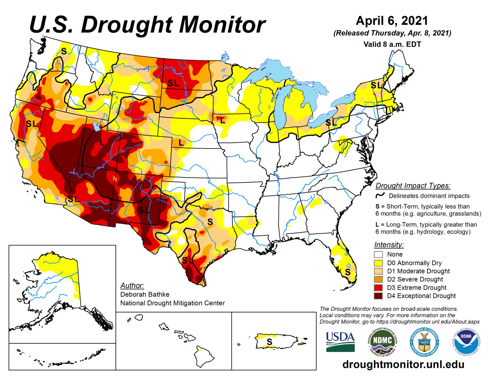
A cold front moving across the eastern half of the country last week brought showers and thunderstorms and left record-breaking cold temperatures in its wake. Meanwhile, dry conditions and warmer than normal temperatures continued in the West with many locations setting daily record high temperatures. The overall effect was a general deterioration of conditions across the Lower 48 as moisture deficits continued to build in the West and in locations in the eastern half of the country that missed out on the heaviest rainfall. Improvements were minimal and limited to parts of the Midwest and Southern Plains.
High Plains
High temperatures in Nebraska and the Dakotas reached the upper 70s to mid-80s last week. With values of about 20 to 30 degrees above normal, many locations set daily records. These warm temperatures combined with low relative humidity and gusty winds to increase fire danger across the region. North and South Dakota declared fire emergencies due to ongoing drought conditions and increased wildfire activity. Severe (D2) and extreme (D3) drought expanded in both states as precipitation deficits continued to grow and increased evaporative demand dried out soils and stressed vegetation.
USDA reports that, as of April 4, 92% of North Dakota’s topsoil and 68% of South Dakota’s topsoil was rated short to very short, indicating that soil moisture supplies are significantly less than what is required for normal crop growth development. In North Dakota, county Extension agents report that producers are starting to de-stock livestock herds by culling cows and grain farmers are very concerned about the lack of moisture. Photos show soil drift due to the dry conditions and high winds.
South
Showers and thunderstorms impacted the Lower Mississippi and Tennessee valleys last week, resulting in improvements to abnormally dry (D0) areas in Mississippi. Having missed out on the heaviest rainfall, drought and abnormal dryness generally expanded in the western part of the region.
In Texas, degradations occurred throughout the state in response to rainfall deficits, increased evaporative demand and vegetation health. Most notable is an expansion of D3 (extreme) and D4 (exceptional) drought in the long-term drought area in the western part of the state. In Oklahoma, this week’s map shows broad expansions of D0 and D1 (moderate drought). Warm, dry weather combined with gusty winds increased evaporative demand, drying out soils and vegetation. The only improvements this week occurred in the Texas Panhandle and western Oklahoma. Despite the lack of rain last week, a reassessment of indicators shows that conditions have started to recover.
Midwest
The most notable weather in the Midwest last week was the development of subfreezing temperatures. Locations in central Ohio, southern Indiana, southern Illinois and Kentucky set daily low records. For the most part, precipitation that fell generally missed the drought areas in the northern part of the region. The cooler than normal temperatures generally kept conditions from deteriorating despite drier than normal weather. Changes to this week’s map include an expansion of moderate drought (D1) in northeast Illinois and southeast Wisconsin in response to rainfall shortages of about 2 to 5 inches over the last 90 days and declining soil moisture.
West
As the wet season begins to wind down in the West, widespread extreme (D3) to exceptional (D4) drought continues across much of the Southwest. Another week of warm, dry weather didn’t help. High temperatures ranged from 4 degrees above normal in the Northwest to 15 degrees above normal in the Southwest while little to no precipitation fell across much of the region. Where exceptions occurred, in the Pacific Northwest and the Northern Rockies, totals generally weren’t enough to overcome shortages. In eastern Washington, abnormal dryness (D0) and moderate drought (D1) expanded as precipitation deficits continued to increase, drying out soils. Conditions also deteriorated in Oregon.
Most notably, D3 expanded and D4 was introduced in south central Oregon in response to record low water-year-to-date total precipitation, streamflow and soil moisture. It’s worth noting that since the U.S. Drought Monitor began in 2000, this is only the second time that D4 has occurred in the state (last occurrence in summer and fall of 2003). In California, the April 1 snow survey showed that snow water content in the Sierra Nevada Mountains was at 59% of average and the state, as a whole, received about 50% of its average precipitation for the water year. Two consecutive dry years have left reservoirs about half full. These precipitation deficits, combined with high temperatures, have reduced streamflow, dried out soils, and stressed vegetation. Changes to this week’s map include an expansion of D3 in northern California and western Nevada and an expansion of D2 (severe drought) and D3 in southern California. D1 expanded in northwest Wyoming and southeast Montana to reflect below normal precipitation over the water year and its effect on soil moisture and streamflow. Eastern Montana also saw deteriorating conditions with an expansion of D2 and D3. Here, the lack of precipitation over the last 2 to 3 months has dried out soils and stressed vegetation. USDA reports that, as of April 4, 76% of the state’s topsoil was rated short to very short indicating that soil moisture supplies are significantly less than what is required for normal crop growth development.


