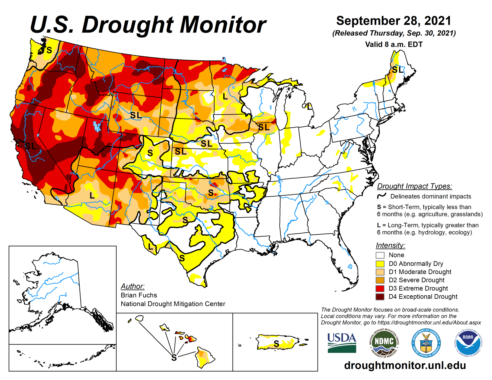
Warm and dry conditions dominated much of the western half of the United States while some needed rain fell on portions of the Midwest, Mid-Atlantic, and into the Northeast. Some late summer precipitation also fell in the deserts of Arizona and New Mexico as well as along the coastal regions of the Pacific Northwest.
As the 2021-22 water year came to a close, the West, northern Plains and upper Midwest had the poorest recorded precipitation while portions of the South and Southeast have recorded 110% to 150% of normal precipitation during this time. Over the last week, temperatures were well below normal in the South and Southeast with some areas of Alabama and Mississippi at 4 to 8 degrees below normal. The warmest temperatures were in the northern Rocky Mountains and into New England where readings were 6 to 8 degrees above normal.
Midwest
Temperatures were variable in the region with the northern areas 1 to 2 degrees above normal while the southern regions were 3 to 4 degrees below normal. The area from central Illinois into Indiana, Ohio, and southern Michigan recorded the most rain this week with portions of northern Indiana recording over 500% of normal.
Abnormally dry conditions were improved over northwest Ohio, northeast Indiana, southern Michigan and portions of southern Wisconsin due to the most recent rains. Where it continued to be dry, drought not only intensified but expanded in portions of Iowa, northern Illinois, southern Wisconsin and southern Missouri. Extreme drought has expanded in the Chicagoland area where this year is looking to be one of the driest on record. Severe drought expanded over much of central Iowa and into northern Illinois and southern Wisconsin and a few small areas of moderate drought were added in southern Missouri.
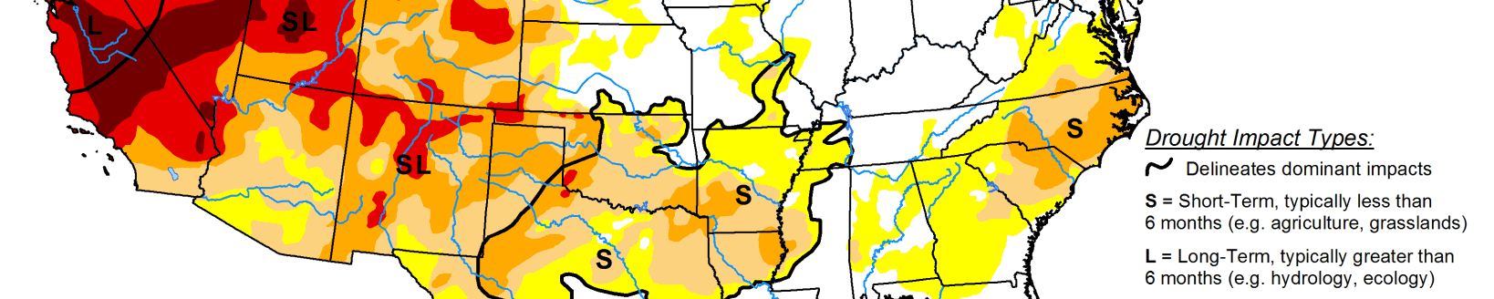
High Plains
Almost the entire region was dry this week with only light precipitation recorded in portions of the region. Most all of the region was at or above normal for temperatures this week with the warmest readings in the Dakotas where temperatures were 6 to 8 degrees above normal. The dry weather coupled with the warm temperatures accelerated grain dry down and maturity, kickstarting harvest in the area. It also allowed for drought to both expand and intensify.
Portions of northwest North Dakota had extreme drought conditions return. Moderate and severe drought were expanded over portions of eastern Colorado, northern and southern Kansas, western and central Nebraska, southwest South Dakota and southeast Wyoming. Severe and extreme drought were also expanded over north central Wyoming. The warm and dry conditions, especially in September, have been the catalyst for degradation over the region that has remained dry.
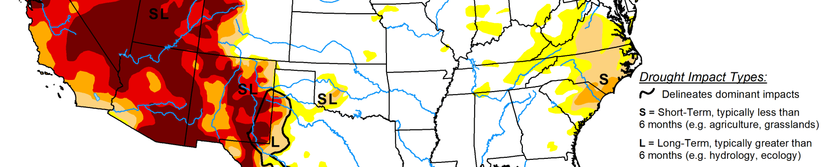
South
Temperatures for the week were cooler than normal over most of the region with departures of 2 to 4 degrees below normal quite common. Portions of west Texas and the panhandles of both Oklahoma and Texas were at to slightly above normal for weekly temperatures. Only a few areas of Arkansas had much measurable precipitation this week, with dryness dominating the region.
Winter wheat being planted into dry soils as well as deteriorating grazing lands have many producers concerned. Almost all of Oklahoma had drought conditions worsen this week with degradation being shown on moderate and severe drought conditions as well as abnormally dry regions expanding. These changes bled into northern and central Texas where large areas of abnormally dry conditions were introduced based upon mainly the last 60 to 90 days.
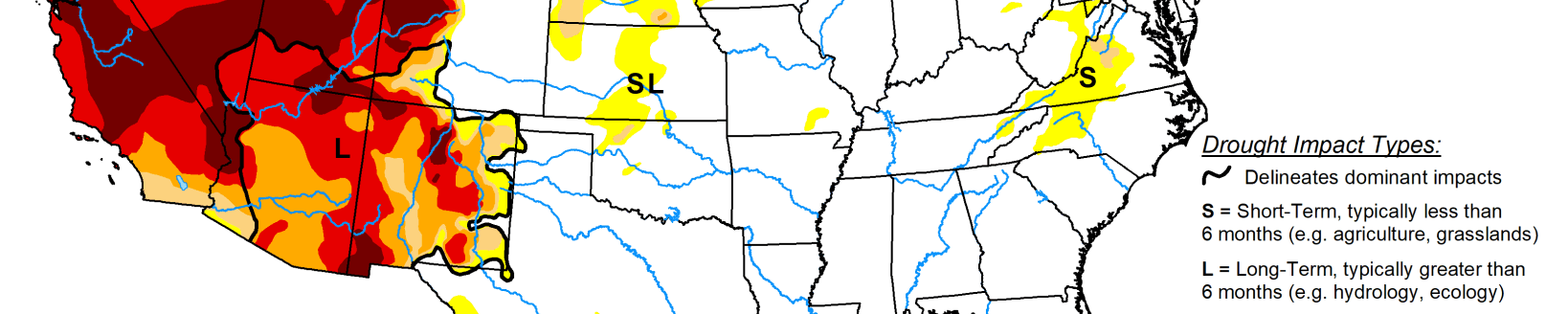
West
Coastal areas from northern California to Washington as well as Arizona and western New Mexico did record some decent precipitation. For the water year ending at the end of September, the 2021-22 period will go down as one of the driest in portions of California and Nevada, where many areas are at 50% or less of their normal values for the time period. Temperatures this last week were near to slightly above normal, with most places 1 to 2 degrees above normal for the week. Portions of central and southern Arizona continued to record much-needed rains and areas of moderate drought were improved there this week, with the “L” designation being the prominent impacts in most of southern Arizona where long-term hydrological issues remain. Some exceptional drought was removed in northeast Nevada and into western Utah while exceptional drought was expanded over western Montana. Moderate drought was intensified to severe drought in the northwest portion of Montana while some exceptional drought was improved over northeast Montana.
Looking ahead
Over the next 5 to 7 days, it is anticipated that the best chances of precipitation will be over the southern Rocky Mountains, Plains, South and into the Midwest and Northeast. The greatest amounts are anticipated over Texas, where up to 4 inches of rain could occur. Temperatures are anticipated to be warmest over the West, northern Plains and Midwest with departures of 9 to 12 degrees above normal during the period. Cooler than normal temperatures are anticipated over the Four Corners region with departures of up to 3 degrees below normal.
The 6- to 10-day outlooks show the high probability of above-normal temperatures over the northern Plains and into the northern Rocky Mountains. Near-normal temperatures are expected over portions of the southern Plains and South while there are higher probabilities of below-normal temperatures along the coastal regions of the Pacific Northwest. Precipitation probabilities are greatest over the West and eastern portions of the country while the upper Midwest and Plains have the greatest chances of below-normal precipitation.