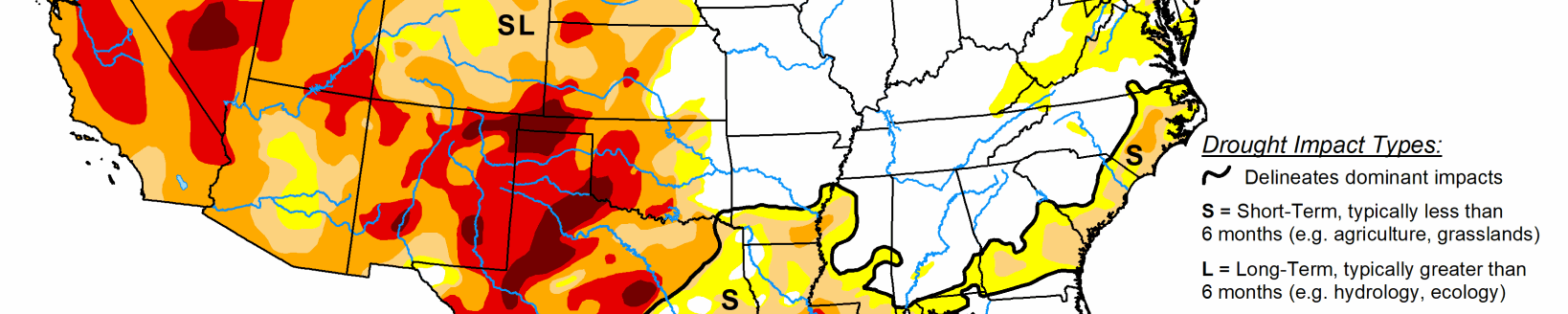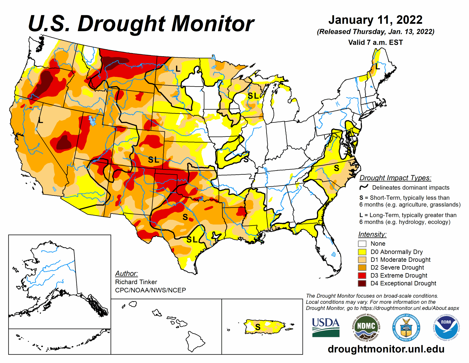
Heavy precipitation pelted the northern half of the West Coast again this week. The largest amounts were reported in westernmost Washington and adjacent Oregon, where 6 to 10 inches of precipitation fell. Similar totals, though less widespread, were recorded across the northern half of the Cascades. Amounts decreased moving southward, with coastal areas and higher elevations from central Oregon to northwestern California receiving 2 to locally near 6 inches. Farther east, 2 to 3 inches were common across the Idaho Panhandle and the higher elevations farther south and east, including western Wyoming and north-central Colorado.
Farther east, heavy precipitation also pelted the southern Ohio Valley and the lower Mississippi Valley. Generally 2 to 3 inches, with isolated higher amounts, fell on a swath south of the Ohio River, central and northeastern Arkansas, and part of easternmost Texas. Moderate precipitation—0.5 to 2.0 inches—fell on parts of the Pacific Northwest, the northern Intermountain West, and the central and northern Rockies adjacent to areas with higher amounts. Similar totals also fell on parts of the Great Lakes Region, and in the East from the Ohio River to the Atlantic and Gulf of Mexico coasts. Light to locally moderate precipitation (0.25 to locally over 0.5 inch) dampened most of the Carolinas, Virginia, the interior Northeast, and portions of the central and northern Great Plains. Elsewhere, little if any precipitation fell, including an area from Oklahoma and Texas westward across much of Nevada and southern California. Looking at the 48 states as a whole, there was considerably more improvement than deterioration, as most areas that were dry this week didn’t seem to deteriorate much, if at all.
South
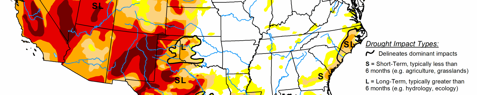
Moderate to heavy precipitation abetted improvement in the eastern reaches of the region while little or no precipitation fell across Oklahoma, western Arkansas, and all but easternmost Texas. In sharp contrast, only light precipitation fell on areas along the Gulf Coast, and little if any precipitation fell on northwestern Arkansas, Oklahoma, and all but easternmost Texas. Over 2 inches of precipitation ended abnormal dryness across central Arkansas and all of Tennessee, save a small residual D0 area in the western part of the state. Heavy precipitation near the southern reaches of the Louisiana/Texas border also prompted some improvement in extreme eastern Texas. Elsewhere, dryness and drought persisted or deteriorated; this region was the only one to experience considerably more deterioration than improvement. Moderate drought expanded southward through most of Louisiana, and many of the D0 to D3 areas increased in coverage across Texas expanded, thus deterioration covered a large proportion of the state.
Midwest
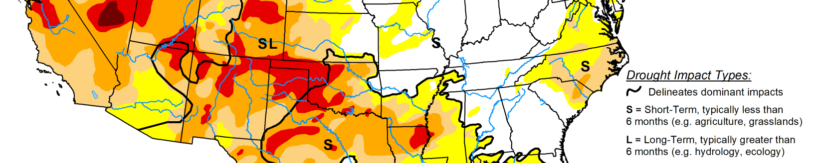
Moderate to heavy precipitation (0.5 to 3.0 inches) were recorded across Kentucky and the Ohio Valley while moderate amounts of 0.5 to 1.5 inches, mostly in the form of snow, fell on the northern half of Minnesota and much of the Great Lakes region. Light precipitation (at best) fell elsewhere. The heaviest precipitation fell on areas not currently in dryness or drought, so improvement was limited to northern reaches of the Great Lakes and adjacent areas. Much of the region was dry, but given the time or year lowering both natural and human water demand, only small patches of deterioration were noted in northwestern Iowa and near the Missouri/Iowa/Illinois triple point.
High Plains
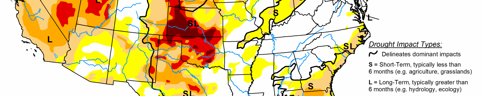
Substantial precipitation (over 0.5 inch) was generally restricted to higher-elevation areas in Wyoming and Colorado. Farther east in the Plains States, only the northern and southern portions of the region recorded more than 0.2 inch. Some deterioration was introduced in southern Kansas where temperatures were the highest, but other areas from the Dakotas southward remained unchanged. Heavy precipitation has been common across the higher elevations of central and northern Colorado in the past couple of months. Some of these mountains received several inches more than normal precipitation in the last 90 days, resulting in abundant snowpack that prompted drought improvement through this region. Other areas were unchanged.
West
Another week of heavy precipitation affected the Pacific Northwest from the Cascades to the Pacific Coast. Precipitation was greatest in western Washington west of Puget Sound, where some areas recorded up to 10 inches of precipitation. Lesser but still above-normal amounts pelted central Washington and north-central Oregon. The valleys east of the Cascades recorded at least 0.5 inch while much of the northern Intermountain West, including most of Idaho and western Montana, reported just under an inch to nearly 3 inches in spots. Farther south, area near the coast as far south as northern California received multiple inches of precipitation, with totals closer to one inch noted in the higher elevations of northern California, including the northern Sierra Nevada. Moderate precipitation also fell on parts of northern Utah. From the Great Basin and central California southward through the southern Rockies, including the southern half of the Four Corners States, most areas received no precipitation. Based on the abundant precipitation and ample snowpack observed so far this winter, improvement was brought into several areas. Most notably, most of the large D3 area covering interior portions of northern and central California were reduced to D2. To the northeast, a significant portion of the D4 in southwestern Montana was improved to D3 for similar reasons. In addition, smaller areas across central Nevada, southern and eastern Oregon, and some central and southeastern portions of Idaho also saw significant improvement since the water year began.